

Paeng now Severe Tropical Storm; Signal No. 3 raised over four areas
Paeng reaches Severe Tropical Storm category and is now offshore of Virac, Catanduanes with Signal No. 3 raised over four areas, according to the later Tropical Cyclone Bulletin posted by PAGASA at 2 a.m. on Saturday.
The center of Severe Tropical Storm Paeng was estimated based on all available data including those from Daet Doppler Weather Radar over the coastal waters of Virac, Catanduanes packing maximum sustained winds of 95 kilometers per hour near the center, gustiness of up to 130 km/h, and central pressure of 985 hPa.
Paeng is presently moving in the west northwest direction at a speed of 30 km/h with extent of Tropical Cyclone Winds strong to storm-force winds extend outwards up to 590 km from the center.
Tropical Cyclone Wind Signal (TCWS) No. 3 has now been hoisted over the following areas:
- Catanduanes
- Camarines Norte
- the northern portion of Camarines Sur (Ragay, Lupi, Sipocot, Libmanan, Cabusao, Magarao, Calabanga, Tinambac, Siruma, Goa, Tigaon, San Jose, Lagonoy, Garchitorena, Presentacion, Caramoan, Saglay, Ocampo, Pili, Bombon, Naga City, Del Gallego, Canaman, Camaligan, Milaor, Gainza, Pamplona)
- the extreme eastern portion of Quezon (Tagkawayan, Guinayangan)
Signal No. 2 is up over the following areas:
Luzon
- Albay
- Sorsogon
- Masbate including Ticao and Burias Islands
- the rest of Camarines Sur
- Marinduque
- the rest of Quezon including Pollilo Islands
- Laguna
- Batangas
- Cavite
- Metro Manila
- Rizal
- Bulacan
- the southern portion of Aurora (San Luis, Baler, Dingalan, Maria Aurora)
- the central and southern portions of Nueva Ecija (City of Gapan, San Leonardo, Santo Domingo, Rizal, San Isidro, Laur, Zaragoza, Llanera, Aliaga, Palayan City,
- Gabaldon, General Mamerto Natividad, Cabanatuan City, Quezon, San Antonio, General Tinio, Santa Rosa, Pe, Jaen, Licab, Bongabon, Cabiao, Talavera)
- the central and southern portions of Tarlac (La Paz, City of Tarlac, San Jose, Gerona, Mayantoc, Pura, Bamban, Capas, Santa Ignacia, Victoria, Concepcion)
- Pampanga
- Bataan
- the central and southern portions of Zambales (Masinloc, Palauig, Iba, Botolan, Cabangan, San Marcelino, Subic, Olongapo City, Castillejos, San Antonio, San Narciso, San Felipe)
- the northern and central portions of Oriental Mindoro (Puerto Galera, San Teodoro, Baco, City of Calapan, Naujan, Victoria, Pola, Socorro, Pinamalayan, Gloria, Bansud, Bongabong, Roxas)
- the northern and central portions of Occidental Mindoro (Sablayan, Santa Cruz, Mamburao, Abra de Ilog, Paluan) including Lubang Islands
- Romblon
Visayas
- Northern Samar
- the northern portion of Eastern Samar (Jipapad, Arteche, Oras,
- San Policarpo, Maslog, Can-Avid, Dolores)
- the northern portion of Samar (Paranas, Motiong, City of Catbalogan, Tarangnan, San Jorge, Jiabong, San Jose de Buan, Matuguinao, Gandara,
- Calbayog City, Santa Margarita, Pagsanghan, Santo Nino, Almagro, Tagapul-An)
Signal No. 1 is hoisted over these areas:
Luzon
- The central and southern portions of Isabela (San Agustin, Jones, City of Santiago, Cordon, Echague, Dinapigue, San Mariano, San Guillermo, Angadanan, City of Cauayan, Benito Soliven, Ramon, San Isidro, Alicia, San Mateo, Cabatuan, Luna, Reina Mercedes, Naguilian, Palanan, Aurora, Burgos, San Manuel, Gamu, Ilagan City, Divilacan, Roxas, Quirino, Mallig)
- Nueva Vizcaya
- Quirino
- Benguet
- Ifugao
- Mountain Province
- the southern portion of Ilocos Sur (Sugpon, Cervantes, Alilem, Suyo, Tagudin, Santa Cruz, Sigay, Quirino, Gregorio del Pilar, Salcedo, Santa Lucia)
- La Union
- the rest of Aurora
- the rest of Nueva Ecija
- the rest of Zambales
- Pangasinan
- the rest of Tarlac
- the rest of Oriental Mindoro
- the rest of Occidental Mindoro
- the northern portion of Palawan (El Nido, Taytay) including Calamian and Cuyo Islands
Visayas
- The rest of Samar
- the rest of Eastern Samar
- Biliran
- Leyte
- Southern Leyte
- Cebu including Bantayan and Camotes Islands
- Bohol
- Negros Occidental
- Negros Oriental
- Guimaras
- Aklan
- Antique
- Capiz
- Iloilo
- Siquijor
- the rest of Leyte
Mindanao
- Dinagat Islands
- Surigao del Norte including Siargao and Bucas Grande Islands
- the northern portion of Surigao del Sur (Carrascal, Cantilan, Madrid, Carmen, Lanuza, Cortes, City of Tandag, Bayabas, Cagwait, San Miguel, Tago, Marihatag, San Agustin, Lianga, Barobo)
- Agusan del Norte
- the northeastern portion of Agusan del Sur (Sibagat, Esperanza, City of Bayugan, Prosperidad)
- Camiguin
- Misamis Oriental
Heavy Rainfall
Heavy to intense with at times torrential rains will likely occur over Bicol Region, Western Visayas, Quezon including Pollilo Islands, Marinduque, Romblon, Samar, Northern Samar, Eastern Samar, Occidental Mindoro and Oriental Mindoro.
Moderate to heavy with at times intense rains likely over Metro Manila, Zamboanga Peninsula, BARMM, Aurora, Bulacan, Palawan including Calamian and Cuyo Islands, Northern Samar, Negros Oriental, Cebu, and the rest of CALABARZON and Eastern Visayas.
Light to moderate with at times heavy rains possible over Nueva Ecija, Pampanga, Bataan, and the rest of Visayas.
From Saturday morning to evening, heavy to intense with at times torrential rains is possible over Metro Manila, CALABARZON, Marinduque, Occidental Mindoro, and Oriental Mindoro.
Moderate to heavy with at times intense rains possible over mainland Cagayan Valley, Cordillera Administrative Region, Western Visayas, Aurora, Nueva
Ecija, Pampanga, Bulacan, Bataan, Romblon, the northern portion of Palawan including Calamian and Cuyo Islands, Camarines Norte, and Camarines Sur.
Light to moderate with at times heavy rains possible over Ilocos Region and the rest of Central Luzon, Bicol Region, and Visayas.
"Under these conditions, widespread flooding and rain-induced landslides are expected, especially in areas that are highly or very highly susceptible to these hazard as identified in hazard maps and in localities with significant antecedent rainfall," PAGASA reported.
Severe Wind
The weather bureau reported that winds of at most storm-force strength may occur within any of the areas under Signal No. 3 is hoisted, while winds reaching gale-force strength are possible in areas under Signal No. 2 while strong winds will be experience in areas under Signal No.1.
"The surge of the Northeast Monsoon enhanced by PAENG will also bring strong winds with gusts reaching gale force strength over Batanes, Babuyan Islands, Ilocos Norte, the northern and eastern portions of mainland Cagayan,
and the northern portion of Apayao," said PAGASA.
Coastal Inundation
There is minimal to moderate risk of storm surge of up to 2.0 m in height which may cause inundation or flooding in the low-lying and exposed coastal areas of Bicol Region, Marinduque, the eastern portion of Batangas, Quezon
including Pollilo Islands, Aurora, and the northern and western portions of Northern Samar.
Track and Intensity Outlook
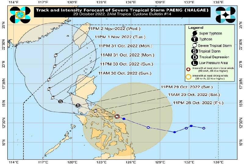
"Severe Tropical Storm PAENG is forecast to continue moving west northwestward through Sunday across Luzon," the bureau reported.
Paeng may make landfall in the vicinity of Albay-Camarines Sur area in the next 6 hours then traverse through the Bicol Peninsula until this noon before crossing the CALABARZON-Metro Manila area early Saturday afternoon through evening.
"After emerging over Manila Bay, PAENG will briefly pass very close or over the Bataan Peninsula-southern Zambales area between this late evening and tomorrow early morning," said PAGASA. -- BAP, GMA News
