

Signal No. 1 up over parts of Cagayan, Isabela as Betty maintains strength
Tropical Cyclone Wind Signal No. 1 was raised over some parts of Cagayan and Isabela as Super Typhoon Betty (international name: Mawar) maintained its strength while moving west northwestward, PAGASA said Saturday.
In its 11 a.m. bulletin, PAGASA said the following areas were under TCWS No.1:
- the eastern portion of Cagayan (Santa Ana, Gonzaga, Lal-Lo, Gattaran, Baggao, Peñablanca, Santa Teresita, Buguey) including Babuyan and Camiguin Islands; and
- the eastern portion of Isabela (Maconacon, Divilacan, Dinapigue, Palanan, San Mariano, Ilagan City, Tumauini, San Pablo, Cabagan).
According to PAGASA, strong winds are of minimal to minor threat to life and property under TCWS No. 1.
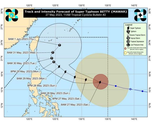
As of 10 a.m., the center of the eye of Super Typhoon Betty was estimated based on all available data at 1,170 km east of Central Luzon (16.4°N, 133.1°E).
Moving west northwestward at 30 km/h, Betty has maximum sustained winds of 195 km/h near the center, gustiness of up to 240 km/h, and central pressure of 915 hPa.
Rainfall forecast
Forecast accumulated rainfall from Monday morning to Tuesday morning will be 50-100 mm in Batanes, Babuyan Islands, and the northern portions of mainland Cagayan, Ilocos Norte, and Apayao.
Meanwhile, from Tuesday morning to Wednesday morning, the forecast accumulated rainfall will be greater than 200 mm in Batanes; 100-200 mm in Babuyan Islands, Ilocos Norte, Ilocos Sur, and La Union; and 50-100 mm in Cordillera Administrative Region and the northern portion of mainland Cagayan.
PAGASA said forecast rainfall are generally higher in elevated or mountainous areas.
Monsoon rains
For areas that will not be directly affected by the super typhoon, monsoon rains from the enhanced Southwest Monsoon will be possible over the western sections of MIMAROPA, Visayas, and Mindanao on Sunday.
On Monday and Tuesday, monsoon rains will be likely over the western sections of MIMAROPA and Western Visayas, and possible over the rest of MIMAROPA and Western Visayas.
“Under these conditions, flooding and rain-induced landslides are likely, especially in areas that are highly or very highly susceptible to these hazard as identified in hazard maps and in localities that experienced considerable amounts of rainfall for the past several days,” PAGASA said.
Severe winds
Strong winds or strong breeze to near gale strength are expected within the areas where TCWS No.1 is currently in effect.
The state weather bureau said the enhanced Southwest Monsoon may bring strong breeze to near gale conditions with intermittent gusts beginning Sunday evening or early Monday over Visayas, the eastern portions of Central and Southern Luzon, and the northern and eastern portions of Mindanao.
Hazards on coastal waters
In the next 24 hours, the eastern seaboards of Luzon and Visayas are expected to experience moderate to rough (1.5 to 3.5 m) seas, which may become rough to very rough (2.5 to 5.0 m). The northern seaboard of Luzon may also experience moderate to rough seas (1.5 to 3.0 m) this morning through afternoon and rough seas (2.5 to 4.0 m) beginning Saturday night.
Mariners of small seacraft are thus advised to take precautionary measures when venturing out to sea and, if possible, avoid navigating in the said conditions. A marine gale warning may be issued within the day in anticipation of these conditions.
Track and intensity outlook
Over the weekend, Super Typhoon Betty is forecast to track generally west northwestward, PAGASA said.
On Monday, the tropical cyclone will turn northwestward and decelerate as it moves over the waters east of Extreme Northern Luzon, and may eventually become almost stationary between late Tuesday and early Wednesday when it will be closest to Batanes (i.e., within 250-300 km).
PAGASA said Betty is forecast to remain as a super typhoon over the weekend.
Although it will likely maintain its strength for the next 36-48 hours, PAGASA is not ruling out a short-term intensification especially in the next 12 to 24 hours.
PAGASA however added that the tropical cyclone may begin weakening considerably on Monday or Tuesday during its slowdown period over the waters east of Batanes due to potential unfavorable conditions (e.g., effect of upwelling of cooler ocean water and dry air intrusion).
Its strong to typhoon-force winds extend outwards up to 600 km from the center.
Classes, preparations
Classes scheduled for Saturday, May 27, in some areas have been canceled as part of the precautionary measures in light of Super Typhoon Betty.
Meanwhile, a total of 34,000 personnel from the Philippine National Police and Armed Forces of the Philippines are ready to conduct search, rescue, and retrieval operations for possible victims of Betty. —KG, GMA Integrated News
