

Signal No. 1 up over 12 areas as Betty moves over Philippine Sea
Tropical Cyclone Wind Signal (TCWS) No. 1 was raised over 12 areas on Sunday morning as Typhoon Betty maintained its strength while moving over the Philippine Sea east of Northern Luzon, PAGASA said in its bulletin.
The areas under TCWS No. 1 are:
- Batanes;
- Cagayan including Babuyan Islands;
- Isabela;
- Apayao;
- Ilocos Norte;
- the northern and central portions of Abra (Tineg, Lacub, Lagayan, San Juan, Lagangilang, Licuan-Baay, Malibcong, Danglas, La Paz, Dolores, Tayum, Bucay, Sallapadan, Daguioman, Bucloc, Boliney);
- Kalinga;
- the eastern and central portions of Mountain Province (Sadanga, Barlig, Natonin, Paracelis, Bontoc);
- the eastern and central portions of Ifugao (Mayoyao, Aguinaldo, Alfonso Lista, Banaue, Hingyon, Lagawe, Lamut, Kiangan, Asipulo);
- the northern and central portions of Aurora (Dilasag, Casiguran, Dinalungan, Dipaculao);
- Quirino; and
- the northeastern portion of Nueva Vizcaya (Kasibu, Quezon, Solano, Bagabag, Diadi, Villaverde, Bayombong, Ambaguio).
PAGASA said the above mentioned areas will experience strong winds of 39 to 61 km/h in 36 hours, which may have minimal to minor threat to life and property. These may begin Sunday night or Monday.
Location
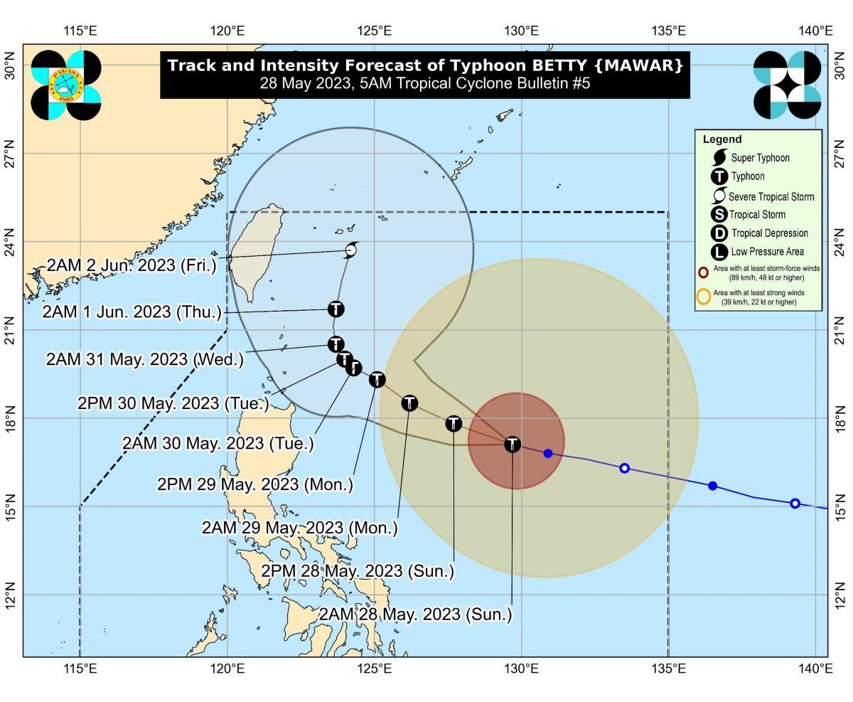
At 4 a.m., the center of Betty was estimated to be located at 815 km east of Northern Luzon.
Betty has maximum sustained winds of 175 km/h near the center, gustiness of up to 215 km/h, and central pressure of 935 hpa.
The typhoon is moving west northwestward at 20 km/h.
From Betty's center, strong to typhoon-force winds are extending outwards up to 740 km.
Betty, a super typhoon when it entered the Philippine Area of Responsibility (PAR) before dawn on Saturday, was downgraded by PAGASA into a typhoon on Saturday night.
Rainfall
From Monday early morning to Tuesday early morning, the eastern portion of Babuyan Islands and the northeastern portion of mainland Cagayan may expect 100 to 200 mm rainfall, PAGASA said.
Meanwhile, Batanes, the northwestern portion of mainland Cagayan, and the northern portions of Ilocos Norte and Apayao may have 50 to 100 mm.
From Tuesday early morning to Wednesday early morning, Batanes, Babuyan Islands, and the northern portion of Ilocos Norte will have rainfall greater than 200 mm.
The northern portion of mainland Cagayan, the rest of Ilocos Norte, Ilocos Sur, La Union, Abra, and Benguet will have 100-200 mm rainfall, while Pangasinan and the rest of Cordillera Administrative Region and mainland Cagayan may expect 50-100 mm rainfall.
From Wednesday early morning to Thursday early morning, Batanes, Ilocos Sur, the northern portion of La Union, and the northern portion of Benguet may experience rainfall greater than 200 mm.
Meanwhile, Babuyan Islands, Ilocos Norte, Abra, and the rest of La Union and Benguet will have 100-200 mm.
The northern portion of mainland Cagayan, Pangasinan, and the rest of Cordillera Administrative Region may expect 50-100 mm rainfall.
Habagat
PAGASA said Betty will enhance the Southwest Monsoon (Habagat).
The western portions of Mimaropa and Western Visayas may possibly have monsoon rains from Monday to Wednesday.
"Under these conditions, flooding and rain-induced landslides are likely, especially in areas that are highly or very highly susceptible to these hazard as identified in hazard maps and in localities that experienced considerable amounts of rainfall for the past several days," PAGASA said.
"The enhanced Southwest Monsoon may also bring occasionally gusts reaching strong breeze to near gale strength beginning tonight or tomorrow morning over most of Visayas, the eastern portion of Central Luzon, the eastern and southern portion of Southern Luzon, and the northern portion of Mindanao. The western portion of Luzon may also experience similar conditions beginning on Tuesday or Wednesday," it added.
Gale warning
PAGASA raised a marine gale warning over the northern and eastern seaboards of Northern Luzon, eastern seaboards of Central and Southern Luzon, and the eastern seaboards of Visayas and Mindanao.
Track, intensity outlook
Betty is expected to move west northwestward or northwestward until Monday, gradually decelerating in the process.
It is also seen to likely become slow-moving to almost stationary by Tuesday while it is over the waters east of Batanes.
From there it will then head northward or north northeastward by mid-Wednesday or Thursday toward the sea east of Taiwan.
Betty will likely remain a typhoon but may gradually weaken until Tuesday.
It may be downgraded into a severe tropical storm on late Thursday or early Friday.
PAGASA advised the public and disaster risk reduction and management offices concerned to take the necessary measures to protect life and property.
"Persons living in areas identified to be highly or very highly susceptible to these hazards are advised to follow evacuation and other instructions from local officials," it said.
The next bulletin will be issued by PAGASA at 11 a.m.
Classes for Monday, May 29, 2023 were canceled in some areas. —KG, GMA Integrated News
