

Signal No. 1 still up over 12 areas as Betty decelerates
Twelve areas in Luzon remained under Tropical Cyclone Wind Signal (TCWS) No. 1 even as Typhoon Betty decelerated while moving westward over the Philippine Sea, PAGASA said on Sunday.
In its 11 a.m. bulletin, the state weather bureau said TCWS No.1 was hoisted over the following areas:
- Batanes;
- Cagayan including Babuyan Islands;
- Isabel;
- Apayao;
- Ilocos Norte;
- the northern and central portions of Abra (Tineg, Lacub, Lagayan, San Juan, Lagangilang, Licuan-Baay, Malibcong, Danglas, La Paz, Dolores, Tayum, Bucay, Sallapadan, Daguioman, Bucloc, Boliney);
- Kalinga;
- the eastern and central portions of Mountain Province (Sadanga, Barlig, Natonin, Paracelis, Bontoc);
- the eastern and central portions of Ifugao (Mayoyao, Aguinaldo, Alfonso Lista, Banaue, Hingyon, Lagawe, Lamut, Kiangan, Asipulo);
- the northern and central portions of Aurora (Dilasag, Casiguran, Dinalungan, Dipaculao);
- Quirino; and
- northeastern portion of Nueva Vizcaya (Kasibu, Quezon, Solano, Bagabag, Diadi, Villaverde, Bayombong, Ambaguio).
Under TCWS No.1, strong winds with speeds ranging 39 to 61 km/h, may prevail within the next 36 hours. Wind impacts may also result in minimal to minor threat to life and property.
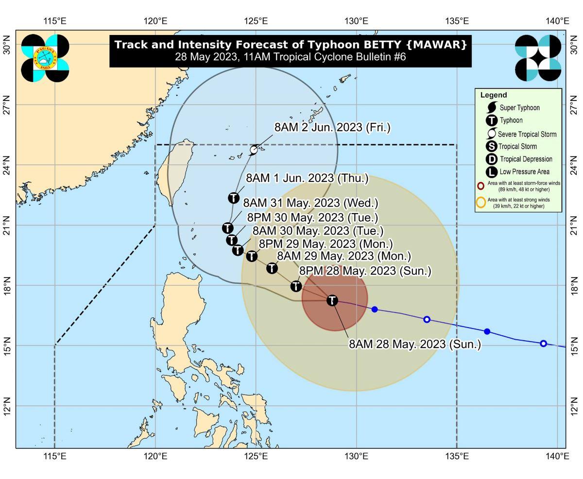
PAGASA said the center of the eye of Betty was last spotted at 10 a.m. at 715 km east of Tuguegarao City, Cagayan (17.3 °N, 128.5 °E).
It has maximum sustained winds of 175 km/h near the center, gustiness of up to 215 km/h, and central pressure of 935 hPa.
Strong to typhoon-force winds also extend outwards up to 740 km from the center.
Its present movement is westward at 15 km/h.
Rainfall, winds, coastal waters
PAGASA said the eastern portion of Babuyan Islands and the northeastern portion of mainland Cagayan may experience 100-200 mm of rainfall from Monday morning to Tuesday morning.
Batanes, the northwestern portion of mainland Cagayan, and the northern portions of Ilocos Norte and Apayao, meanwhile, may see 50-100 mm of rainfall during the same period.
Betty will also enhance the Southwest Monsoon this week, with monsoon rains expected over the western portions of Mimaropa and Western Visayas on Monday.
The enhanced Southwest Monsoon may also occasionally bring gusts reaching strong breeze to near gale strength beginning Sunday night or Monday morning over most of Visayas, the eastern portion of Central Luzon, the eastern and southern portion of Southern Luzon, and the northern portion of Mindanao.
The western portion of Luzon may also experience similar conditions beginning on Tuesday or Wednesday.
Further, a marine gale warning remains in effect over the northern and eastern seaboards of Northern Luzon, eastern seaboards of Central and Southern Luzon, and the eastern seaboards of Visayas and Mindanao due to Betty.
Track, intensity
PAGASA said Betty will move west northwestward or northwestward until Monday, while gradually decelerating. It will likely become slow-moving to almost stationary by Tuesday while over the waters east of Batanes.
Betty will then move northward or north northeastward by mid Wednesday or Thursday towards the sea east of Taiwan.
The typhoon may also be downgraded to severe tropical storm category on late Thursday or early Friday.
Classes for Monday, May 29 were canceled in some areas in anticipation of bad weather from Betty. —LBG/KG, GMA Integrated News
