
Chedeng further intensifies over Philippine Sea, moving west northwestward
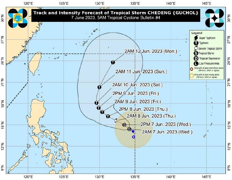
Tropical Storm Chedeng further intensifies over the Philippine Sea at it continues to move in the west northwest direction, according to the Tropical Cyclone Bulletin PAGASA posted early Wednesday morning.
The center of Tropical Storm Chedeng was estimated at 1,060 kilometers east of Southeastern Luzon packing maximum sustained winds of 75 kilometers near the center, gustiness of up to 90 km/h, and central pressure of 998 hPa.
Chedeng is moving west northwestward at a speed of 10 km/h with strong to gale-force winds extend outwards up to 340 km from the center.
There are no Wind Signals hoisted at this time.
Hazards affecting land areas
Tropical Storm Chedeng is unlikely to directly bring heavy rainfall over any portion of the country in the next 3 to 5 days.
Although the current forecast scenario for this tropical cyclone may result in the enhancement of the Southwest Monsoon, the timing and intensity of monsoon rains over the country especially in the western portion) may still change.
Palawan will have cloudy skies with rain showers and thunderstorms due to the southwest monsoon with the possible occurrence of flash floods or landslides due to moderate to at times heavy rains.
Metro Manila and the rest of the country will have partly cloudy to cloudy skies with isolated rain showers or thunderstorms due to the southwest monsoon and localized thunderstorms. Flash floods or landslides may occur during severe thunderstorms.
Severe Winds
The hoisting of Wind Signals in anticipation of tropical cyclone severe winds is unlikely at this time.
The Southwest Monsoon may be strengthened as a result of Chedeng, but under the current forecast scenario, the likelihood of intermittent wind gusts resulting from the monsoon winds may still change.
Meanwhile, Tropical Storm Chedeng remains unlikely to cause rough sea condition over the coastal waters of the country in the next 24 hours.
Track and Intensity outlook
"As Chedeng continues to consolidate while intensifying, it is forecast to move generally northwestward or west northwestward today through mid-Friday, before turning more northward or north northeastward for the rest of Friday through weekend," PAGASA said, adding that the tropical storm will remain far from the Philippine landmass.
"Owing to favorable environmental conditions, Chedeng is forecast to intensify in the next 3 to 4 days and may be upgraded to severe tropical storm category tonight or tomorrow and into a typhoon on Thursday. Rapid intensification is not ruled out. Peak intensity may be reached by Friday or Saturday," the weather bureau added.
Sunrise will be at 5:26 a.m., sunset at 6:24 p.m. -- BAP, GMA Integrated News
