
PAGASA: Egay nearing super typhoon category; 42 areas under storm signals
Typhoon Egay further intensified and is nearing super typhoon category, PAGASA reported early Tuesday.
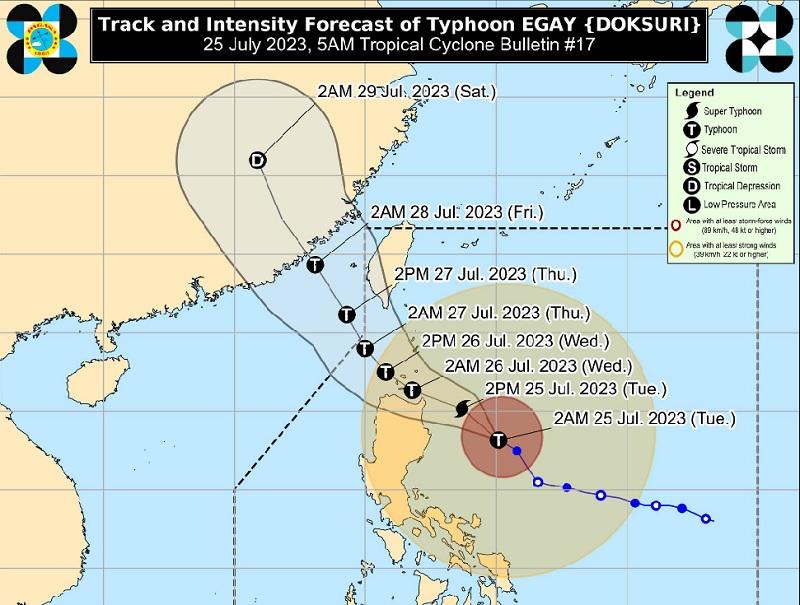
In its 5 a.m. Tropical Cyclone Bulletin, PAGASA said the center of Egay was estimated to be situated 350 kilometers east of Tuguegarao City, Cagayan packing maximum sustained winds of 175 kilometers per hour near the center and gustiness of up to 215 km/h and and central pressure of 935 hPa.
Egay is moving northwestward at the speed of 15 km/h with strong to typhoon-force winds extend outwards up to 680 km from the center.
Tropical Cyclone Wind Signal (TCWS) No. 3 is hoisted over the following areas:
- Babuyan Islands
- the northern and eastern portions of mainland Cagayan (Santa Ana, Gonzaga, Peñablanca, Gattaran, Lal-Lo, Alcala, Santa Teresita, Buguey, Aparri, Camalaniugan, Ballesteros, Allacapan, Abulug, Claveria, Pamplona, Sanchez-Mira, Santa Praxedes, Lasam, Baggao, Amulung, Iguig)
- the northeastern portion of Isabela (Divilacan, Maconacon, Palanan)
- the northern portion of Apayao (Calanasan, Luna, Santa Marcela, Flora, Pudtol)
TCWS No. 2 is hoisted over the following areas in Luzon:
- Batanes
- the rest of mainland Cagayan, the rest of Isabela, Quirino, the northern portion of Nueva Vizcaya (Kasibu, Quezon, Diadi, Bagabag, Ambaguio, Villaverde, Solano, Bayombong)
- the rest of Apayao
- Kalinga
- Abra
- Mountain Province
- Ifugao
- the northern portion of Benguet (Bakun, Mankayan, Buguias, Kabayan, Kibungan)
- Ilocos Norte
- Ilocos Sur
- the northern and central portion of Aurora (Dilasag, Casiguran, Dinalungan, Dipaculao)
TCWS No. 1 is raised over the following areas:
LUZON
- La Union
- Pangasinan
- the rest of Benguet
- the rest of Nueva Vizcaya
- the rest of Aurora
- Zambales
- Bataan
- Nueva Ecija
- Tarlac
- Pampanga
- Bulacan
- Metro Manila
- Rizal
- Laguna
- Cavite
- Batangas
- Quezon
- Marinduque
- Camarines Norte
- Camarines Sur
- Catanduanes
- Albay
- Sorsogon
- the northern portion of Masbate (Uson, Dimasalang, City of Masbate, Mobo, Palanas, Aroroy, Baleno) including Burias and Ticao Islands
VISAYAS
- Northern Samar
- the northern portion of Samar (San Jose de Buan, Matuguinao, Gandara, Santa Margarita, Calbayog City)
- the northern portion of Eastern Samar (Oras, Arteche, Jipapad, Dolores, San Policarpo, Maslog)
Track and Intensity outlook
PAGASA said Egay is forecast to move northwestward in the next 12 hours before turning generally west northwestward and cross the Luzon Strait.
On the track forecast, the typhoon is forecast to make landfall or pass very close to Babuyan Islands-northeastern mainland Cagayan area between late evening on Tuesday and Wednesday afternoon.
The weather bureau said a slight northward or southward shift may result in a landfall or close approach over northern mainland Cagayan or Batanes.
After passing the Babuyan Islands, Egay will turn northwestward or north northwestward and pass over the waters south of Taiwan and is is forecast to exit the Philippine Area of Responsibility on Thursday morning, it added.
Heavy Rainfall Outlook
Forecast accumulated rainfall of above 200 mm over the eastern portion of Babuyan Islands and the northern portions of mainland Cagayan, Apayao, and Ilocos Norte and 100-200 mm over Ilocos Sur, Abra, the northern portion of La Union, the western portion of Kalinga, and the rest of Babuyan Islands, mainland Cagayan, and Apayao.
PAGASA said there is about 50-100 mm of rain expected over Batanes, the northern and eastern portions of Isabela, the northern portion of Zambales, and the rest of Ilocos Region and Cordillera Administrative Region.
The Southwest Monsoon enhanced by Egay will continue to bring occasional to monsoon rains over the western portions of Central Luzon, Southern Luzon, and Visayas in the next three days, PAGASA said.
The Ilocos Region, Cordillera Administrative Region, Cagayan Valley, and Aurora will experience stormy weather due to Egay, it added.
The weather bureau said flooding or landslides in these areas may occur due to heavy to intense rains and there may be minor to moderate threat to lives and properties due to strong winds.
PAGASA said Metro Manila, CALABARZON, the Bicol Region, Marinduque, Romblon, and the rest of Central Luzon will have rains with gusty winds due to Egay with possible flooding or landslides occurring due to moderate to heavy rains. There may be minimal to minor threat to lives and properties due to strong winds.
The Visayas, Zamboanga Peninsula, BARMM, SOCCSKSARGEN, Lanao del Norte, and the rest of Luzon will have cloudy skies with scattered rain showers and thunderstorms due to Egay and the Southwest Monsoon or Habagat, PAGASA said.
Flash floods or landslides may occur due to moderate to at times heavy rains, it added.
The rest of the Mindanao will have partly cloudy to cloudy skies with isolated rain showers or thunderstorms due to the southwest monsoon and localized thunderstorms with flash floods or landslides possibly occurring during severe thunderstorms.
Severe Winds
PAGASA reported that there would be moderate to significant impacts from storm-force winds may be experienced within the areas under Signal No. 3 while minor to moderate impacts from gale-force winds are possible within any of the areas where Signal No. 2 is in effect.
Minimal to minor impacts from strong winds are also possible within any of the areas where Wind Signal No.1 is hoisted.
Hazards affecting coastal waters
"Under the influence of EGAY, a Gale Warning is in effect over several coastal waters along the seaboards of Northern Luzon, Southern Luzon, and Visayas and eastern seaboards of Central Luzon and Northeastern Mindanao," PAGASA said.
"All mariners are advised to remain in port or seek safe harbor until winds and waves subside," the agency added. — BAP/RSJ, GMA Integrated News
