

Signal No. 3 still up over eastern Isabela as Goring maintains strength
The eastern portion of Isabela remained under Tropical Cyclone Wind Signal (TCWS) No. 3 as Super Typhoon Goring (international name: Saola) maintained its strength while moving south southwestward, PAGASA said late Sunday morning.
Based on its 11 a.m. bulletin, the state weather bureau said TCWS No. 3 was hoisted particularly over the towns of Divilacan, Palanan, Dinapigue, Ilagan City, and San Mariano in the province of Isabela.
Strong to typhoon-force winds greater than 89 km/h and up to 117 km/h may be expected in these towns in the next 18 hours. Wind impacts may also result in moderate to significant threat to life and property.
Meanwhile, the following areas are under TCWS No. 2:
- the eastern portion of mainland Cagayan (Peñablanca, Baggao, Gattaran, Lal-Lo, Gonzaga, Santa Teresita, Buguey, Santa Ana, Enrile, Tuguegarao City);
- the northern and central portion of Isabela (Maconacon, Cabagan, Tumauini, San Pablo, Benito Soliven, San Guillermo, Jones, Echague, San Agustin, Angadanan, City of Cauayan, Naguilian, Gamu, Santa Maria, Santo Tomas, Delfin Albano, Quirino, Burgos, Reina Mercedes, Alicia, Luna, Quezon, Mallig, Roxas, San Manuel, Aurora, Cabatuan, San Mateo, San Isidro);
- the extreme northern portion of Aurora (Casiguran, Dinalungan, Dilasag); and
- the eastern portion of Quirino (Maddela).
Gale-force winds ranging 62 to 88 km/h may occur in these areas within the next 24 hours. Wind impacts may also result in minor to moderate threat to life and property.
TCWS No. 1 on the other hand was raised over these areas:
- Batanes;
- the rest of Cagayan including Babuyan Islands;
- the rest of Aurora;
- the rest of Quirino;
- the rest of Isabela;
- Apayao;
- Nueva Vizcaya;
- Ifugao;
- Mountain Province;
- Kalinga;
- Abra;
- eastern portion of Ilocos Norte (Pagudpud, Adams, Vintar, Carasi, Nueva Era, Banna, Marcos, Dingras, Solsona, Piddig, Dumalneg, Bangui);
- Pollilo Islands;
- eastern portion of Benguet (Bokod, Buguias, Kabayan, Mankayan);
- eastern portion of Nueva Ecija (Carranglan, Pantabangan, Bongabon, Gabaldon, Laur, Rizal); and
- Calaguas Islands.
Strong winds from 39 to 61 km/h may be expected in these areas within the next 36 hours. Wind impacts may result in minimal to minor threat to life and property.
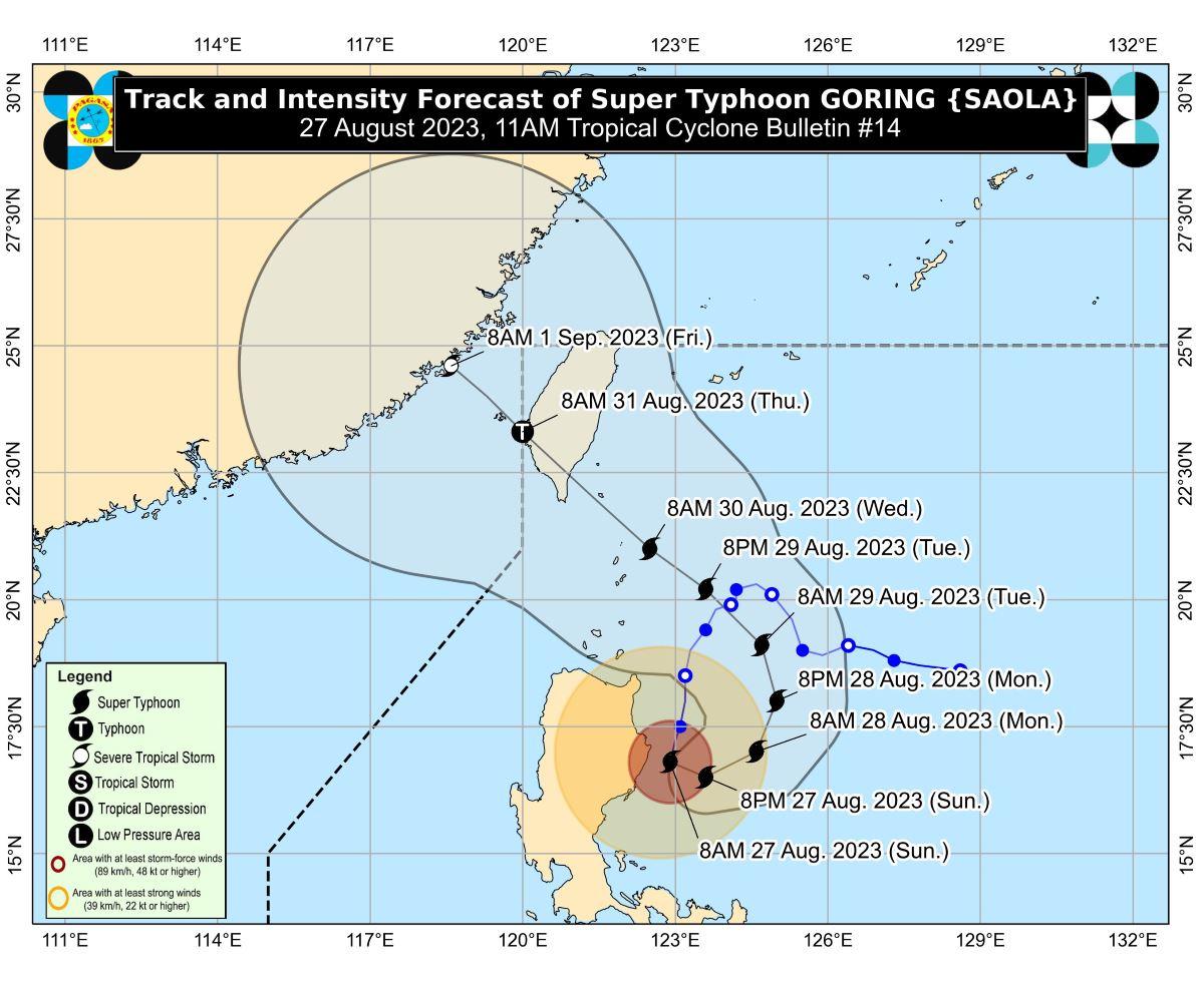
The center of the eye of Goring was last estimated at 95 kilometers east northeast of Casiguran, Aurora.
It was moving south southwestward at a speed of 10 km/h.
Goring has maximum sustained winds of 185 km/h near the center, gustiness of up to 230 km/h, and central pressure of 935 hPa.
Strong to typhoon-force winds also extend outwards up to 260 km from the center.
Habagat
According to PAGASA, the Southwest Monsoon (Habagat) being enhanced by Goring will bring occasional or monsoon rains over the western portions of Central Luzon, Southern Luzon, and Visayas over the next three days.
The enhanced Southwest Monsoon will continue to bring gusty conditions over the following areas not under any Wind Signal, especially in coastal and upland or mountainous areas exposed to winds:
• Sunday: Aurora, Bataan, Metro Manila, Calabarzon, Mimaropa, Bicol Region, Visayas, Dinagat Islands, and Camiguin.
• Monday: Aurora, Bataan, Metro Manila, Calabarzon, Mimaropa, Bicol Region, Visayas, Dinagat Islands, Camiguin, and most of Zamboanga Peninsula.
• Tuesday: Aurora, Bataan, Bulacan, Metro Manila, Calabarzon, Mimaropa, Bicol Region, Visayas, Dinagat Islands, Camiguin, and most of Zamboanga Peninsula.
A gale warning is in effect for the northern and eastern coastal waters of Luzon due to Goring.
Track, intensity
PAGASA said Goring is seen to remain at a super typhoon category until it makes landfall over southern Taiwan.
Based on the track forecast, Goring will make landfall over the southern portion of Taiwan on Wednesday evening or on Thursday early morning. It may exit the Philippine Area of Responsibility (PAR) on Friday.
“Land interaction with Taiwan’s rugged terrain will weaken the super typhoon. It is likely that GORING will emerge over the Taiwan Strait and exit the PAR region on Friday as a severe tropical storm or a typhoon in its lowest limit,” the state weather bureau said.
On Sunday, Goring is forecast to begin its loop over the Philippine Sea east of Cagayan-Isabela area.
The super typhoon will then turn northeastward and northward on Monday before shifting northwestward on Tuesday.
Effects
The provinces of Cagayan and Isabela have started to feel the effects of Goring on Saturday night.
Heavy rains and strong winds knocked down some electric posts, rendering almost the entire Districts 1 and 2 without power, Cagayan Provincial Disaster Risk Reduction and Management Office (PDRRMO) head Ruelie Rapsing said on Sunday.
There were also fallen trees reported near the municipality of Sta. Teresita, he added.
Flooding was also reported in the towns of Lal-lo, Sta. Ana, and Gonzaga.
Some residents in the town of Baggao were evacuated due to the threat of landslide.
Meanwhile, some residents in the coastal town of Divilacan in Isabela were evacuated as their houses are made of light materials, PDRRMO head Atty. Constante Foronda Jr. said. —KG, GMA Integrated News
