
Hanna maintains strength, moves west northwestward over Philippine Sea
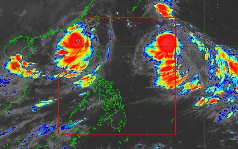
Severe Tropical Storm Hanna maintains its strength while moving west northwestward over the Philippine Sea, according to PAGASA on Thursday morning.
As of 4 a.m., the center of Hanna was estimated at 1,225 kilometers east of Extreme Northern Luzon packing maximum sustained winds of 95 kilometers per hour near the center, gustiness of up to 115 km/h, and central pressure of 990 hPa.
PAGASA said Hanna is moving west northwestward at a speed of 20 km/h with strong to storm-force winds extend outwards up to 340 km from the center.
Hazards affecting land areas
The southwest monsoon (Habagat) enhanced by Super Typhoon Saola (Goring), which is now outside the Philippine Area of Responsibility (PAR), is also being slightly enhanced by Hanna and Tropical Storm Kirogi that is currently outside the PAR.
Habagat will bring occasional to monsoon rains over the western portions of Luzon in the next three days.
Batanes, Cagayan including Babuyan Islands, Ilocos Norte, and Apayao will have cloudy skies with scattered to widespread rain showers and thunderstorms due to the Trough of Super Typhoon Saola, with flooding or landslides possibly occurring due to scattered to widespread rains.
Zambales, Bataan, and Occidental Mindoro will have rains due to Habagat with possible occurrence of flooding or landslides due to heavy to intense rains.
Metro Manila, Abra, Benguet, Tarlac, Pampanga, Bulacan, Cavite, Batangas, and the rest of Ilocos Region will have occasional rains due to Habagat with flooding or landslides possibly occurring due to moderate to heavy rains.
Meanwhile, Antique, the rest of Cordillera Administrative Region, the rest of Cagayan Valley, the rest of Central Luzon, the rest of CALABARZON, and the rest of MIMAROPA will have cloudy skies with scattered rain showers and thunderstorms due to Habagat, with flooding or landslides possibly occurring due to moderate with at times heavy rains.
The rest of the country will have partly cloudy to cloudy skies with isolated rain showers or thunderstorms due to Habagat and localized thunderstorms with flash floods or landslides possibly occurring during severe thunderstorms.
Severe Winds
PAGASA reported that the enhanced Southwest Monsoon will continue to bring gusty conditions over the following areas not under any Wind Signal, especially in coastal and upland/mountainous areas exposed to winds on Wednesday and Thursdayover Ilocos Region, Cordillera Administrative Region, Zambales, Bataan, Aurora, Bulacan, Metro Manila, CALABARZON, MIMAROPA, Bicol Region, Western Visayas, and the northern portion of Eastern Visayas.
Hazards affecting coastal waters
Hanna is less likely to bring rough sea conditions over any seaboard of the country through the forecast period, the weather bureau said.
However, due to the Southwest Monsoon that it is slightly enhancing, a Gale Warning is in effect for most seaboards of Luzon and Visayas.
Track and Intensity Outlook
"Hanna is forecast to move generally west northwestward or northwestward at a fairly consistent speed throughout the forecast period," said PAGASA.
"On the forecast track, this tropical cyclone is forecast to remain far from the Philippine landmass and may exit the Philippine Area of Responsibility (PAR) tomorrow afternoon or evening while approaching the Ryukyu Islands," the bureau added. — BAP, GMA Integrated News
