
Signal No. 1 up in 22 areas as Aghon passes over San Francisco, Quezon
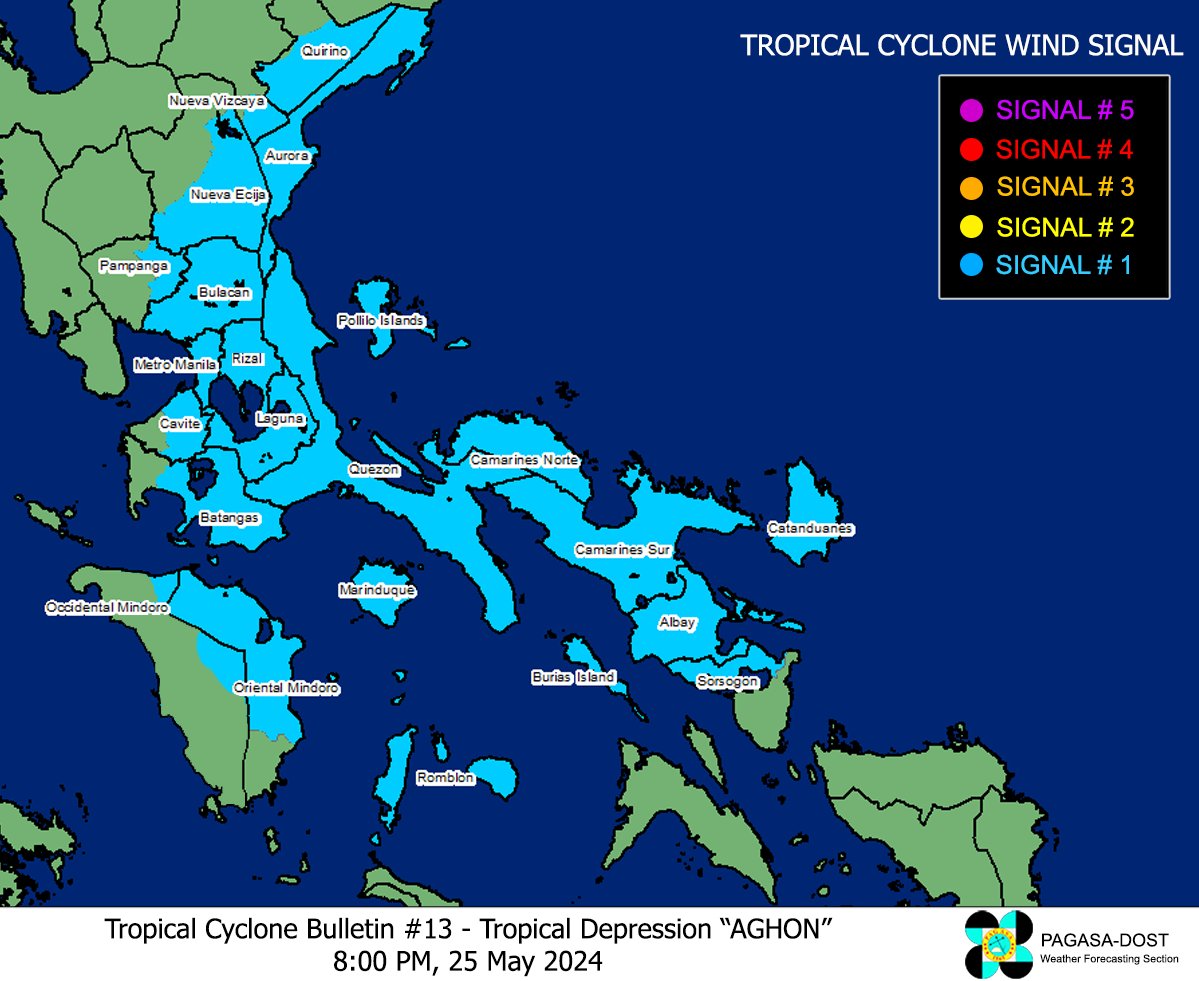
Tropical Depression Aghon has slowed down while traversing the waters of San Francisco, Quezon Province, the state weather bureau PAGASA said on Saturday evening.
In its 8 p.m. bulletin, PAGASA said Aghon was moving west northwestward at 15 km/h, down from 20 km/h three hours earlier, with maximum sustained winds of 45 km/h near the center and gustiness of up to 70 km/h.
Twenty-two areas were placed under Tropical Cylone Wind Signal No. 1:
- Quirino (Maddela, Nagtipunan)
- Nueva Vizcaya (Alfonso Castaneda)
- Nueva Ecija (General Tinio, Gabaldon, Bongabon, Pantabangan, Rizal, General Mamerto Natividad, Laur, Palayan City, Peñaranda, San Leonardo, City of Gapan, Cabanatuan City, Santa Rosa, San Isidro, Cabiao, San Antonio, Jaen)
- Pampanga (Candaba, San Luis, San Simon, Apalit, Santa Ana, Arayat)
- Bulacan
- Aurora
- Metro Manila
- Cavite (Mendez, Gen. Mariano Alvarez, Noveleta, Silang, City of Dasmariñas, City of General Trias, Amadeo, Carmona, Kawit, Rosario, Tanza, Alfonso, Tagaytay City, Bacoor City, Trece Martires City, Imus City, Indang)
- Laguna
- Rizal
- Batangas (Lobo, Taysan, Rosario, Padre Garcia, San Juan, Santo Tomas, Batangas City, Tingloy, Bauan, San Luis, Mabini, San Pascual, San Jose, Ibaan, Lipa City, Mataasnakahoy, Balete, Malvar, Calaca, Cuenca, Talisay, Agoncillo, Lemery, City of Tanauan, Alitagtag, San Nicolas, Laurel, Santa Teresita, Taal)
- Quezon including Polillo Islands
- Camarines Norte
- Camarines Sur
- Catanduanes
- Albay
- Sorsogon (Pilar, Castilla, Donsol, City of Sorsogon)
- Masbate including Burias Island
- Oriental Mindoro (Pinamalayan, Pola, Naujan, Victoria, Socorro, City of Calapan, Bansud, Gloria, Baco, San Teodoro, Puerto Galera, Bongabong, Roxas)
- Occidental Mindoro (Sablayan, Abra de Ilog)
- Marinduque
- Romblon
From Saturday evening to Sunday morning, the expected accumulated rainfall will be 100–200 mm in Quezon, including the Polillo Islands, the eastern portions of Laguna and Rizal, Marinduque, Romblon, Camarines Norte, Camarines Sur, and Catanduanes, and 50–100 mm in the eastern portion of Isabela, Aurora, Metro Manila, the rest of Calabarzon, Oriental Mindoro, Occidental Mindoro, and the northern portion of Western Visayas.
From Sunday evening to Monday morning, 100–200 mm of rain is expected in Quezon, including the Polillo Islands, Camarines Norte, Camarines Sur, and Catanduanes, and 50–100 mm of rain is expected in Aurora, the eastern portions of Isabela, Laguna, Rizal, Albay, and the northern portion of Masbate, including Burias Island.
Moderate to rough seas may also be expected over the coastal waters along the seaboards of Calabarzon, Mimaropa, Bicol Region, and the northern seaboards of Western Visayas.
PAGASA said Aghon was forecast to move generally northwestward over Sibuyan Sea and Tayabas Bay, and may possibly make landfall over Marinduque within the next 12 hours.
''During this period, weakening into low pressure area (LPA) is not ruled out,'' it said.
''Aghon will then continue to move northwestward and may possibly make another landfall over Batangas or Quezon and traverse Calabarzon area. Re-intensification is possible and it may reach tropical storm category by tomorrow as Aghon emerges over Polillo Strait.'' —Jiselle Anne Casucian/VBL, GMA Integrated News
