

TD Bising exits PAR but may reenter Monday morning
Tropical Depression Bising has left the Philippine Area of Responsibility, but may reenter by Monday morning, state weather bureau PAGASA said.
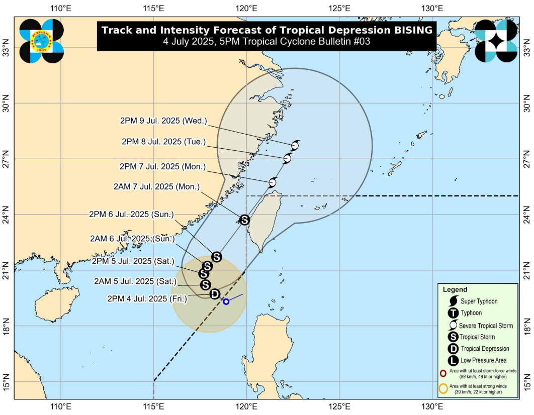
According to its 5 p.m. cyclone bulletin on Friday, PAGASA said Bising was spotted 345 kms west northwest of Calayan, Cagayan.
The weather disturbance was moving northwestward at 15 kph.
It currently has maximum sustained winds of 55 kph and gusts of up to 70 kph.
Strong winds were extending outwards up to 250 kms from the center.
Bising's location was reported based on PAGASA's tracking as of 4 p.m.
No tropical cyclone wind signal (TCWS) was in effect over any part of the country as of posting time.
However, PAGASA said the tropical depression may intensify into a tropical storm within the next 12 hours as it moves over the north of Taiwan.
After possible reentry on Monday morning, it may exit the PAR on the afternoon of the same day.
"Re-entry to the western boundary of the PAR is possible by Monday (07 July) early morning and it may exit again the northern boundary of PAR on Monday afternoon. The forecast track is highly uncertain and the possibility of a southward shift in track is becoming less likely," the cyclone bulletin read.
Habagat effects remain
In a separate 5 p.m. weather advisory, PAGASA said the Southwest Monsoon or Habagat and Bising will cause heavy rains over the following parts of the country:
Friday to Saturday afternoon
- 50-100mm: Ilocos Norte, Batanes, Ilocos Sur and La Union
Saturday afternoon to Sunday afternoon
- 50-100mm: Batanes, Ilocos Norte and Ilocos Sur
The trough of the tropical cyclone was expected to bring heavy rains in Ilocos Norte and Batanes, while the habagat was forecast to also affect Ilocos Norte, Ilocos Sur, and La Union.
"Forecast rainfall may be higher in mountainous and elevated areas. Moreover, impacts in some areas may be worsened by significant antecedent rainfall," the advisory read.
The monsoon and the periphery of Bising will also cause gale-force gusts over the following areas:
Friday
- Ilocos Region, Isabela, the northern portion of Aurora, Zambales, Occidental Mindoro, Marinduque, Romblon, Palawan, and Antique
Saturday
- The rest of Ilocos Norte, Ilocos Sur, La Union, Pangasinan, Isabela, the northern portion of Aurora, Zambales, Bataan, Cavite, Oriental Mindoro, Occidental Mindoro, Marinduque, Romblon, Palawan, and Antique
Sunday
- The rest of Ilocos Norte, Ilocos Sur, La Union, Pangasinan, Isabela, the northern portion of Aurora, Zambales, Bataan, Metro Manila, Cavite, Oriental Mindoro, Occidental Mindoro, Marinduque, Romblon, Palawan, and Antique
Meanwhile, PAGASA has advised affected public and disaster risk reduction management offices to implement the necessary precautionary measures to protect life and property.
— VDV, GMA Integrated News
