

Crising slightly accelerates; Signal No. 1 remains over 21 areas
Tropical Depression Crising slightly accelerates while maintaining its strength over the sea east of Aurora province as Signal No. 1 remains over 21 provinces, according to the 2 a.m. Tropical Cyclone Bulletin posted by PAGASA.
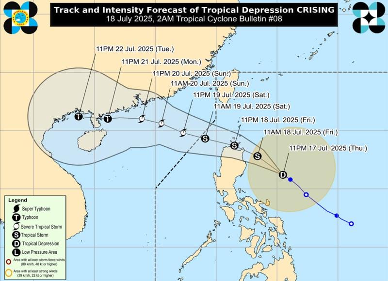
The center of Tropical Depression Crising was estimated at 350 kilometers east of Casiguran, Aurora packing maximum sustained winds of 55 kilometers per hour and gustiness of up to 70 kph, and moving northwestward at the speed of 20kph.
Tropical Cyclones Wind Signal (TCWS) No. 1 is hoisted over the following areas:
- Batanes
- Cagayan including Babuyan Islands
- Isabela
- Apayao
- Abra
- Ilocos Norte
- Ilocos Sur
- Kalinga
- Mountain Province
- Ifugao
- Benguet
- La Union
- Quirino
- the northern portion of Aurora (Dilasag, Casiguran, Dinalungan, Dipaculao, Baler, Maria Aurora)
- Nueva Vizcaya
- the northern portion of Pangasinan (San Nicolas, Natividad, San Quintin, San Manuel, Tayug, Sison, San Fabian, Pozorrubio, Laoac, Binalonan, San Jacinto, Manaoag, Mangaldan, Dagupan City, Binmaley, Lingayen, Labrador, Sual, City of Alaminos, Bolinao, Anda, Bani, Agno, Burgos, Mabini, Dasol, Calasiao, Santa Barbara, Mapandan, Bugallon)
- the northern portion of Nueva Ecija (Carranglan, Pantabangan)
- Polillo Islands
- Camarines Norte
- the northeastern portion of Camarines Sur (Caramoan, Garchitorena, Lagonoy, San Jose, Presentacion, Tinambac, Siruma, Goa)
- Catanduanes
Hazards affecting land areas
Heavy rainfall is expected tonight up to Friday evening over the following areas due to Crising: Cagayan and Isabela (more than 200mm); Apayao, Kalinga, Quirino, Aurora, Quezon, Camarines Norte and Camarines Sur (100-200mm); Ilocos Norte, Ilocos Sur, La Union, Pangasinan, Abra, Mountain Province, Ifugao, Albay, Sorsogon, Masbate, Catanduanes, Northern Samar, Eastern Samar, Samar, and Biliran (50-100mm).
The southwest monsoon or habagat will bring heavy rainfall tonight up to Friday evening on the following areas: Palawan, Occidental Mindoro, Iloilo, Guimaras, Antique, and Negros Occidental (100-200mm); Metro Manila, Zambales, Bataan, Bulacan, Rizal, Cavite, Batangas, Laguna, Oriental Mindoro, Marinduque, Romblon, Aklan, Capiz, Negros Oriental, Siquijor, Cebu, Zamboanga del Norte, Lanao del Norte, and Lanao del Sur (50-100mm).
Severe Winds
PAGASA said minimal to minor impacts from strong winds are possible within any of the areas under Wind Signal No. 1.
"Once CRISING intensifies into a Tropical Storm, there is likelihood that the hoisted wind signals will be upgraded to Wind Signal No. 2 over the southern portion of Batanes, Cagayan including Babuyan Islands, Apayao, Ilocos Norte, and the northern portions of Ilocos Sur, Abra, Kalinga, and Isabela," the agency added.
The Southwest Monsoon will bring strong to gale-force gusts over the following areas (especially in coastal and upland areas exposed to winds): Batangas, Quezon, the rest of Bicol Region, MIMAROPA, Visayas, Zamboanga del Norte, Camiguin, Surigao del Norte, Dinagat Islands, Davao Occidental, Davao Oriental, and Sarangani.
Coastal Inundation
There is a minimal to moderate risk of life-threatening storm surge with peak heights reaching 1.0 to 2.0 m in the next 48 hours over the low-lying or exposed coastal localities of Cagayan including Babuyan Islands, Isabela, Ilocos Norte, and Ilocos Sur.
Hazards affecting coastal waters
Very rough seas is expected over the northern and eastern seaboards of Batanes.
The bureau warned that sea travel is risky for all types or tonnage of vessels.
"All mariners must remain in port or, if underway, seek shelter or safe harbor as soon as possible until winds and waves subside."
Rough seas expected over the following coastal waters: the eastern seaboard of Cagayan including Babuyan Islands and the remaining seaboards of Batanes, the northern seaboard of Cagayan; the eastern seaboards of Isabela and northern Aurora; the western seaboard of Palawan; the southern seaboards of Antique, Iloilo, and Guimaras; the western and southern seaboards of Negros Occidental.
Mariners of small seacrafts, including all types of motorbancas, are advised not to venture out to sea under these conditions, especially if inexperienced or operating ill-equipped vessels.
For areas affected by moderate seas, such as the remaining seaboards of Palawan; the northern and western seaboards of Zamboanga del Norte and Camiguin; the southern seaboards of Siquijor, Bohol and Southern Leyte; the eastern seaboards of Davao Region; and the seaboards of Surigao del Norte and Dinagat Islands, the western seaboard of Occidental Mindoro and Romblon; the northwestern seaboard of Masbate, the remaining seaboards of Aurora and Antique; the northern and eastern seaboards of Polillo Islands and Catanduanes; the northern seaboards of Camarines Norte and Camarines Sur; and the eastern seaboards of Northern and Eastern Samar.
"Mariners of motorbancas and similarly-sized vessels are advised to take precautionary measures while venturing out to sea and, if possible, avoid navigation under these conditions."
Track and Intensity Outlook
Tropical Depression Crising will move generally northwestward over the next 24 hours and may make landfall scenario over mainland Cagayan or Babuyan Islands on Friday afternoon or evening.
Crising is then forecasted to move west northwestward traversing the northern portion of Northern Luzon until it exits the Philippine Area of Responsibility by Saturday afternoon or evening. — BAP, GMA Integrated News
