

Crising intensifies; Signal No. 2 raised over 8 areas
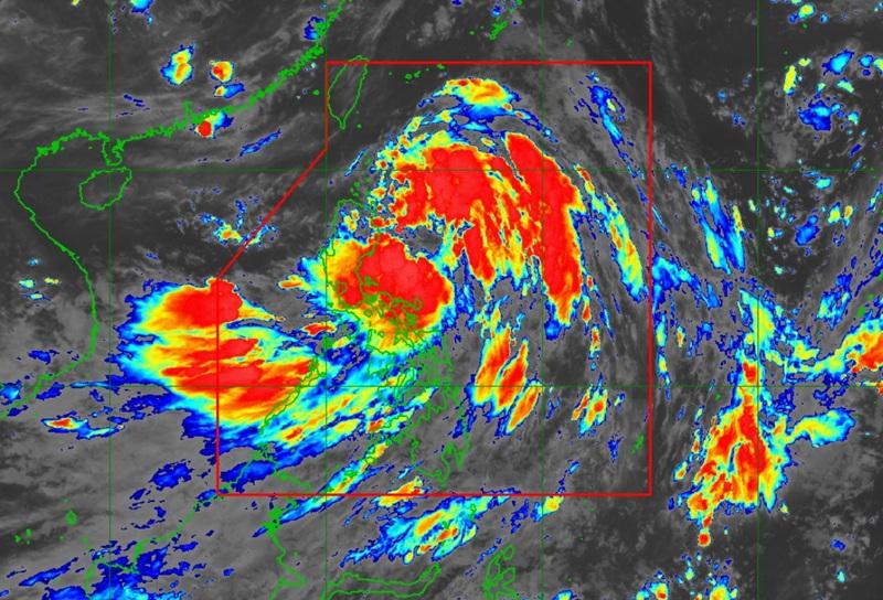
Crising intensifies into a tropical storm as it approaches Norther Luzon with Signal No. 2 raised over eight areas, according to the latest Tropical Cyclone Bulletin posted by PAGASA.
The center of the eye of the tropical storm was estimated at 335 kilometers east of Echague, Isabela or 325 km east of Tuguegarao City, Cagayan packing maximum sustained winds of 65 kilometers per hour near the center, gustiness of up to 80 kph, and moving northwestward at the speed of 20 kph.
Tropical Cyclone Wind Signal (TCWS) No. 2 is hoisted over the following areas:
- Batanes
- Cagayan including Babuyan Islands
- the northern and eastern portions of Isabela (Palanan, Ilagan City, Divilacan, Delfin Albano, Quezon, Tumauini, Maconacon, Santa Maria, Cabagan, San Pablo, Santo Tomas, San Mariano, Dinapigue)
- Apayao
- the northern portion of Kalinga (City of Tabuk, Balbalan, Pinukpuk, Rizal)
- the northern portion of Abra (Malibcong, Lacub, Lagangilang, Licuan-Baay, Danglas, Lagayan, San Juan, Tineg, La Paz, Dolores)
- Ilocos Norte
- the northern portion of Ilocos Sur (Cabugao, Sinait)
Tropical Cyclone Wind Signal No. 1 is raised over the following areas:
- the rest of Isabela
- Quirino
- Nueva Vizcaya
- the rest of Kalinga
- Mountain Province
- Ifugao
- the rest of Abra
- Benguet
- the rest of Ilocos Sur
- La Union
- the northern portion of Pangasinan (San Nicolas, Natividad, San Quintin, San Manuel, Tayug, Sison, San Fabian, Pozorrubio, Laoac, Binalonan, San Jacinto, Manaoag, Mangaldan, Dagupan City, Binmaley, Lingayen, Labrador, Sual, City of Alaminos, Bolinao, Anda, Bani, Agno, Burgos, Mabini, Dasol, Calasiao, Santa Barbara, Mapandan, Bugallon)
- the northern portion of Aurora (Dilasag, Casiguran, Dinalungan, Dipaculao, Baler, Maria Aurora)
- the northeastern portion of Nueva Ecija (Carranglan, Pantabangan)
- Polillo Islands
- Camarines Norte
- Catanduanes
- the northeastern portion Camarines Sur (Caramoan, Garchitorena, Lagonoy, San Jose, Presentacion, Tinambac, Siruma, Goa)
Hazards affecting land areas
Heavy rainfall outlook over the following areas due to Crising: Cagayan, Isabela, Apayao, and Ilocos Norte (200mm); Batanes, Ilocos Sur, Benguet, Kalinga, Abra, Quirino, La Union, Aurora, Quezon, Camarines Norte and Camarines Sur (100-200mm); Pangasinan, Nueva Vizcaya, Mountain Province, Ifugao, Albay, Sorsogon, Masbate, and Catanduanes (50mm to 100mm).
The following areas will experience heavy rainfall due to the southwest monsoon or habagat: Palawan, Occidental Mindoro, Iloilo, Guimaras, Antique, and Negros Occidental (100-200mm); Metro Manila, Zambales, Bataan, Tarlac, Pampanga, Nueva Ecija, Bulacan, Rizal, Cavite, Batangas, Laguna, Oriental Mindoro, Marinduque, Romblon, Aklan, Capiz, Negros Oriental, and Zamboanga del Norte (50-100mm).
The Southwest Monsoon will also bring strong to gale-force gusts over the following areas (especially in coastal and upland areas exposed to winds): Batangas, Quezon, the rest of Bicol Region, MIMAROPA, Visayas, Zamboanga del Norte, Camiguin, Misamis Oriental Surigao del Norte, Dinagat Islands, Davao Occidental, Davao Oriental, and Sarangani.
Coastal Inundation
PAGASA reported minimal to moderate risk of life-threatening storm surge with peak heights reaching 1.0 to 2.0 m may be expected in the next 48 hours over the low-lying or exposed coastal localities of Cagayan including Babuyan Islands, Isabela, Ilocos Norte, and Ilocos Sur.
Hazards affecting coastal waters
A Gale Warning is hoisted over the northern seaboard of Northern Luzon.
The state weather bureau warned that sea travel is risky and that all mariners must remain in port or, if underway, seek shelter or safe harbor as soon as possible until winds and waves subside and to take precautionary measures while venturing out to sea and, if possible, avoid navigation under these conditions.
Track and Intensity Outlook
Tropical Storm Crising will move generally northwestward within the next 12 hours and may make landfall over mainland Cagayan or Babuyan Islands this afternoon or evening.
Crising will will then move west northwestward traversing over extreme Northern Luzon until it exits the Philippine Area of Responsibility by Saturday afternoon. — BAP, GMA Integrated News
