

Emong accelerates, about to make second landfall; two areas under Signal No. 4
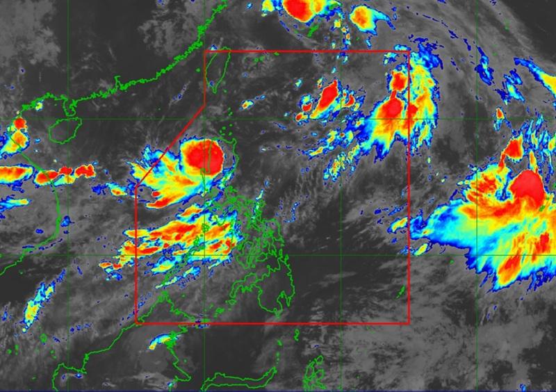
Typhoon Emong accelerates and is about to make a second landfall, this time in Ilocos Sur or the northern portion of La Union, according to the latest Tropical Cyclone Bulletin posted by PAGASA.
The center of Typhoon Emong was estimated to be over the coastal waters of Bangar, La Union packing maximum sustained winds of 120 kilometers per hour near the center, gustiness of up to 165 km/h, and central pressure of 975 hPa.
Emong is moving northeastward at the speed of 20 km/h with strong to typhoon-force winds extend outwards up to 260 km from the center.
Tropical Cyclone Wind Signal (TCWS) No. 4 in which typhoon-force winds are expected and wind speed between 118 to 184 km/h is raised over the following areas:
- the southwestern portion of Ilocos Sur (Santa Lucia, Santa Cruz, Tagudin, Alilem, Sugpon, Suyo)
- the northern and central portions of La Union (Bangar, Luna, Balaoan, Bacnotan, San Juan, City of San Fernando, Bauang, Sudipen, Santol, Caba, Aringay, San Gabriel, Bagulin, Naguilian, Burgos)
TCWS No. 3, with storm-force winds and wind speeds between 89 to 117 km/h is raised over the following areas:
- the southern portion of Ilocos Norte (Laoag City, San Nicolas, Sarrat, Dingras, Solsona, Nueva Era, City of Batac, Marcos, Paoay, Currimao, Banna, Pinili, Badoc)
- the rest of Ilocos Sur, the rest of La Union, the western portion of Apayao (Conner, Kabugao, Calanasan)
- Abra
- the western portion of Kalinga (Balbalan, Pasil, Tinglayan, Lubuagan)
- the western portion of Mountain Province (Besao, Tadian, Sagada, Bauko, Sabangan, Bontoc, Sadanga)
- the western portion of Benguet (Sablan, Mankayan, Tuba, Bakun, Kibungan, Kapangan, La Trinidad, Tublay, Baguio City, Atok)
- the northern portion of Pangasinan (Lingayen, Bugallon, Infanta, Dagupan City, San Fabian, Binmaley, Labrador, Sison, Pozorrubio, San Jacinto, Mangaldan, Calasiao, Santa Barbara, Mapandan, San Carlos City, Aguilar, Bolinao, Bani, City of Alaminos, Sual, Mabini, Dasol, Burgos, Agno, Anda)
TCWS No. 2, with gale-force winds and wind speed between 62 to 88 km/h is hoisted over the following areas:
- the rest of Ilocos Norte
- the rest of Pangasinan
- the northern portion of Zambales (Masinloc, Candelaria, Palauig, Iba, Santa Cruz)
- the rest of Apayao
- the rest of Kalinga
- the rest of Mountain Province
- the rest of Benguet
- Ifugao
- Batanes
- Cagayan including Babuyan Islands
- the northern and western portions of Isabela (Cordon, City of Santiago, Ramon, San Isidro, Alicia, San Mateo, Cabatuan, San Manuel, Luna, Aurora, Burgos, Roxas, Quirino, Mallig, Delfin Albano, Quezon, Cabagan, Santa Maria, San Pablo, Maconacon, Santo Tomas, Tumauini, Gamu, Ilagan City, City of Cauayan, Reina Mercedes, Naguilian)
- the northwestern portion of Quirino (Diffun)
- the western and central portions of Nueva Vizcaya (Kayapa, Santa Fe, Ambaguio, Aritao, Bambang, Bayombong, Villaverde, Solano, Bagabag, Dupax del Sur, Dupax del Norte, Kasibu, Quezon, Diadi)
- the northwestern portion of Nueva Ecija (Nampicuan, Cuyapo, Talugtug, Lupao, Carranglan, Guimba)
- the northern portion of Tarlac (Mayantoc, Santa Ignacia, Gerona, Pura, Ramos, Anao, San Manuel, Moncada, Paniqui, Camiling, San Clemente)
TCWS No.1 with strong winds and wind speed between 39 to 61 km/h is hoisted over the following areas:
- the rest of Isabela
- the rest of Quirino
- the rest of Nueva Vizcaya
- the northern and central portions of Aurora (Dilasag, Casiguran, Dinalungan, Dipaculao, Maria Aurora, Baler, San Luis)
- the rest of Nueva Ecija
- the rest of Tarlac
- the western and central portions of Pampanga (Porac, Floridablanca, Angeles City, Mabalacat City, Magalang, Mexico, Bacolor, City of San Fernando, Santa Rita, Guagua, Arayat, Lubao, Santa Ana)
- the rest of Zambales
- the northern portion of Bataan (Dinalupihan, Hermosa, Morong)
Heavy rainfall outlook
The enhanced Southwest Monsoon will bring strong to gale-force gusts over the following areas (especially in coastal and upland areas exposed to winds): Central Luzon (areas not under Wind Signal), Metro Manila, CALABARZON, Bicol Region, MIMAROPA, Visayas, Zamboanga del Norte, Misamis Occidental, Lanao del Norte, Camiguin, Dinagat Islands, and Davao Oriental.
Tracking and Intensity outlook
"On the forecast track, the center of EMONG will make another landfall in Ilocos Sur or La Union this morning. Afterwards, it will cross the mountainous terrain of Northern Luzon and emerge over the Babuyan Channel before noon," said PAGASA.
"Emong will then move northeastward and pass close or over Babuyan Islands between this noon and afternoon. It may also pass near Batanes between this afternoon or evening. Emong may maintain its strength as it makes its second landfall." — BAP, GMA Integrated News
