

Southwest Monsoon to continue bringing rains over parts of PH

The Southwest Monsoon (Habagat) will continue to bring rains over parts of the country on Sunday, state weather bureau PAGASA said.
Ilocos Sur, La Union, Pangasinan, Zambales, Bataan, and Occidental Mindoro may have occasional rains due to the monsoon. Moderate to at times heavy rains may possibly result in floods or landslides.
Metro Manila, Cordillera Administrative Region, Cagayan Valley, CALABARZON, the rest of Ilocos Region, the rest of Central Luzon, and the rest of MIMAROPA may expect cloudy skies with scattered rains and thunderstorms also due to the Southwest Monsoon. Flash floods or landslides may possibly occur due to moderate to at times heavy rains.
The rest of the country will experience generally fair weather, with partly cloudy to cloudy skies with isolated rains or thunderstorms. During severe thunderstorms, flash floods or landslides may result.
Coastal waters will be rough in Extreme Northern Luzon, and moderate to rough in the western section of Luzon.
As for the rest of the country, these will have slight to moderate coastal waters.
Sunrise was at 5:38 a.m. while sunset will be at 6:27 p.m.
Weather disturbances outside PAR
Meanwhile, PAGASA is monitoring three weather disturbances outside the Philippine Area of Responsibility (PAR).
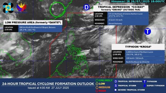
A low pressure area, formerly known as Dante when it was inside PAR, was estimated to be located at 2 a.m. at 690 km north northwest of Itbayat, Batanes.
"Maliit ang tsansa nito na lumakas at inaasahang malulusaw na ito sa mga susunod na oras," DOST-PAGASA weather specialist Obet Badrina said in the bureau's 5 a.m. public weather forecast.
(It has a small chance of intensifying and is expected to dissipate in the next few hours.)
Tropical Depression Co-May, formerly known as Emong when it was inside PAR, was located at 3 a.m. at 875 km northeast of Extreme Northern Luzon. It was packing maximum sustained winds of 45 km/h near the center and with gustiness of up to 55 km/h. Co-May is almost stationary.
"Inaasahang malulusaw na ito sa mga susunod na araw (This is expected to dissipate in the next few days)," Badrina said.
Typhoon Krosa, meanwhile, is also being monitored by PAGASA even if it is outside PAR.
At 3 a.m., Krosa was estimated to be located at 2,480 km east of Extreme Northern Luzon, having maximum sustained winds of 120 km/h near the center, with gustiness of up to 150 km/h. Krosa was moving north northeastward at 20 km/h.
"Hindi natin inaasahang papasok ito ng PAR. Tuluyan itong lalayo sa ating bansa," Badrina said.
(We are not expecting Krosa to enter PAR. It will continue to move farther away from our country.)
Badrina said no LPA is inside PAR today. "Medyo maliit ang tsansa na magkaroon tayo ng bagyo sa mga susunod na araw," he added.
(The chance of having a tropical depression in the country in the next few days is small.) —KG, GMA Integrated News
