Gorio slows down, might become typhoon before Taiwan landfall; no immediate impact on PH

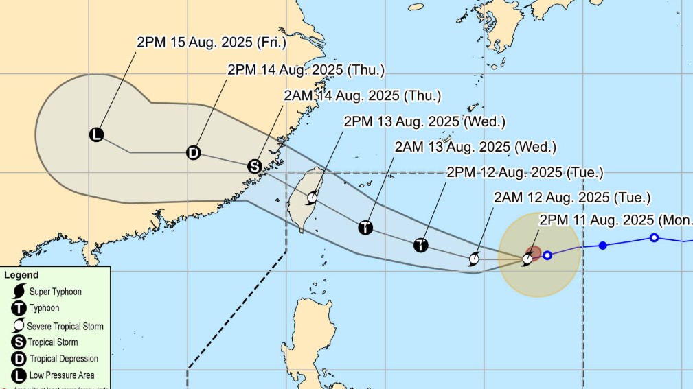
Severe Tropical Storm Gorio has slightly decelerated as it moves west-southwestward over the Philippine Sea, according to the latest advisory from PAGASA on Monday afternoon.
Based on its 5 p.m. bulletin, the state weather bureau said the storm’s center was located approximately 1,045 kilometers east of Extreme Northern Luzon (at latitude 20.5°N, longitude 132.0°E), moving at a slower pace of 20 kilometers per hour.
It currently carries maximum sustained winds of 110 kilometers per hour near the center, with gusts reaching up to 135 kilometers per hour.
PAGASA forecasts that Gorio will generally continue moving westward over the next 12 hours, then gradually turn west-northwestward starting Tuesday afternoon through the end of the forecast period. The tropical cyclone may reach typhoon strength before making landfall over the eastern coast of Taiwan by Wednesday afternoon, August 13.
Gorio is expected to exit the Philippine Area of Responsibility (PAR) by Wednesday evening.
For the Philippines, PAGASA noted that Gorio is unlikely to directly affect the country within the next three days. However, the agency cautioned that a further southward shift in the storm’s track could lead to the hoisting of Tropical Cyclone Wind Signal No. 1 over Extreme Northern Luzon.
Meanwhile, moderate seas up to 2.0 meters are expected over the coastal waters of Extreme Northern Luzon due to the storm’s influence. PAGASA advised mariners of motor bancas and similarly sized vessels to take precautionary measures when venturing out to sea. It recommended avoiding navigation in these conditions, especially for inexperienced operators or vessels that are ill-equipped. — Sherylin Untalan/RF, GMA Integrated News


