

Gorio intensifies into typhoon; Habagat to bring cloudy skies, rains over most of PH
Severe Tropical Storm Gorio intensified into a typhoon as it moved westward over the Philippine Sea on Tuesday, PAGASA said. The Southwest Monsoon (Habagat) meanwhile will bring cloudy skies, rains over Southern Luzon, Visayas, and Mindanao.
As of 4 a.m., the center of Typhoon Gorio was estimated at 745 kilometers east of Itbayat, Batanes packing maximum sustained winds of 120 kilometers per hour near the center, and with gustiness of up to 150 km/h, central pressure of 980 hPa. Gorio is moving westward at a speed of 25 km/h.
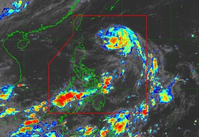
There will be strong to storm-force winds extending outwards up to 310 km from the center of the typhoon. But PAGASA also reported that there are no wind signals currently hoisted over the country.
Severe winds
"GORIO’s current track forecast shows a low chance of it directly affecting the country within the next three days. However, in the event of a further southward shift in the forecast track, hoisting of Tropical Cyclone Wind Signal over Extreme Northern Luzon is not ruled out," the state weather bureau also reported.
Hazards affecting coastal areas
"Gorio will bring up to moderate seas (up to 2.5 m) over the coastal waters of Extreme Northern Luzon. Mariners of motor bancas and similarly sized vessels are advised to take precautionary measures while venturing out to sea and, if possible, avoid navigating in these conditions, especially if inexperienced or operating ill-equipped vessels," the agency added.
Track and intensity outlook
Typhoon Gorio is forecast to move in the west northwest direction and may make landfall over the eastern coast of Taiwan on August 13, Wednesday afternoon and exit the Philippine Area of Responsibility (PAR) by evening.
Gorio will have no effect on any part of the country but the Southwest Monsoon will bring cloudy skies with rain showers over the western sections of Southern Luzon, Visayas, and Mindanao.
Forecast weather conditions
MIMAROPA, Western Visayas, Negros Island Region, and Zamboanga Peninsula will have cloudy skies with scattered rain showers and thunderstorms due to the monsoon and flash floods or landslides may occur during severe thunderstorms.
Metro Manila and the rest of the country will have partly cloudy to cloudy skies with isolated rain showers or thunderstorms due to localized thunderstorms. Flash floods or landslides may result during severe thunderstorms.
The forecast wind speed for extreme Northern Luzon is moderate to strong and moving in the northwest to west. Coastal waters will be moderate to rough.
The rest of Northern Luzon and the eastern sections of Central and Southern Luzon will experience light to moderate winds moving in the west to northwest direction, and slight to moderate coastal waters.
The rest of the country will have light to moderate winds moving in the southwest to northwest direction, while coastal waters will be slight to moderate.
Sunrise will be at 5:42 a.m., sunset 6:21 p.m. — BAP/KG, GMA Integrated News
