

Signal No. 1 up over Batanes as Gorio moves westward over Philippine Sea
Tropical Cyclone Wind Signal (TCWS) No. 1 was raised over Batanes on Tuesday morning as Typhoon Gorio (Podul) maintained its strength as it moved westward over the Philippine Sea, PAGASA said.
Under TCWS No. 1, Batanes will experience strong winds with speeds of 39 to 61 km/h in 36 hours, posing minimal to minor threat to life and property, the weather bureau said in its 11 a.m. bulletin.
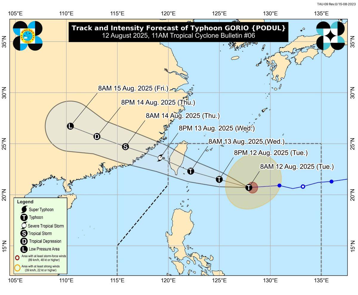
Gorio is forecast to slightly intensify before making landfall over Taiwan, PAGASA said.
The typhoon was last spotted at 10 a.m. at 560 kilometers east of Itbayat, Batanes, packing maximum sustained winds of 120 kilometers per hour (kph) near the center and with gustiness of up to 150 kph. It was moving west at 25 kph.
While the typhoon is not expected to make landfall in the Philippines, PAGASA said strong to gale-force winds are expected in some parts of Extreme Northern Luzon due to the enhanced Southwest Monsoon. The highest possible wind signal that may be raised is TCWS No. 2 in Batanes, while areas under TCWS No. 1 may experience minimal to minor wind impacts.
Wind and monsoon effects
Today, the Babuyan Islands and the northern portion of mainland Cagayan will experience strong to gale-force gusts, especially in coastal and upland areas exposed to winds. By Wednesday, these conditions may also affect the northern portion of Ilocos Norte.
PAGASA warned that winds could be stronger in coastal and mountainous areas exposed to the prevailing wind direction, and less intense in sheltered areas.
Rough seas in northern waters
The typhoon will also cause dangerous sea conditions, with waves reaching up to 5.5 meters along the seaboards of Batanes. Sea travel is risky for all vessels in these waters, and mariners are advised to remain in port or seek safe harbor until conditions improve.
Rough seas of up to 3.5 meters are expected over the northern and eastern seaboards of the Babuyan Islands, while moderate seas of 2.0 to 2.5 meters will persist in parts of mainland Cagayan, Isabela, and Aurora. PAGASA advised small fishing boats and motorbancas to avoid venturing out to sea, especially if ill-equipped or operated by inexperienced crew.
Track and forecast
Gorio is forecast to move west-northwestward for the rest of its track, making landfall over the eastern coast of Taiwan by Wednesday afternoon before exiting the Philippine Area of Responsibility (PAR) in the evening. It may slightly intensify before landfall and then weaken as it crosses Taiwan.
PAGASA will issue the next weather bulletin at 5 p.m. -KG, GMA Integrated News
