

Signal No. 1 up in 14 areas as Mirasol moves to N. Luzon

Tropical Cyclone Wind Signal (TCWS) No. 1 has been raised in over 14 areas as Tropical Depression Mirasol was traversing Northern Luzon on Wednesday morning, state weather bureau Pagasa said.
In its 8 a.m. bulletin, Pagasa said TCWS No. 1 is in effect in the following areas:
- Batanes
- Cagayan including Babuyan Islands
- Isabela
- Quirino
- The northern and central portions of Aurora (Dilasag, Casiguran, Dinalungan, Dipaculao, Baler, Maria Aurora, San Luis)
- Apayao
- Abra
- Kalinga
- Mountain Province
- Ifugao
- The northern and eastern portion of Benguet (Bakun, Mankayan, Kabayan, Buguias, Kibungan, Atok, Bokod)
- Nueva Vizcaya
- Ilocos Norte
- Ilocos Sur
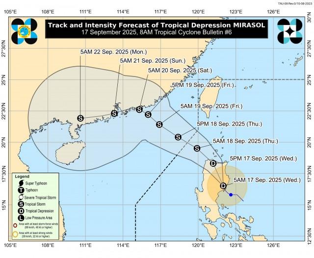
Mirasol was last spotted in the vicinity of San Agustin, Isabela, packing maximum sustained winds of 55 kilometers per hour near the center and gustiness of up to 90 kph.
The tropical depression was moving west northwestward at 25 kph.
“Mirasol is forecast to move north northwestward within the next 12 hours while traversing Northern Luzon,” Pagasa said.
“This tropical depression will re-emerge over the Luzon Strait by this afternoon or evening and will continue moving northwestward to west northwestward until it exits the Philippine Area of Responsibility tomorrow (18 September) morning or afternoon,” it added.
Once Mirasol is over the Luzon Strait, Pagasa said it is expected to intensify and may reach tropical storm category by Thursday morning.
“On the forecast track, MIRASOL will remain as a tropical storm throughout the forecast period. However, further intensification to severe tropical storm is not ruled out,” it added. —VAL, GMA Integrated News
