

Heavy rains seen as Mirasol moves over Ilocos Norte
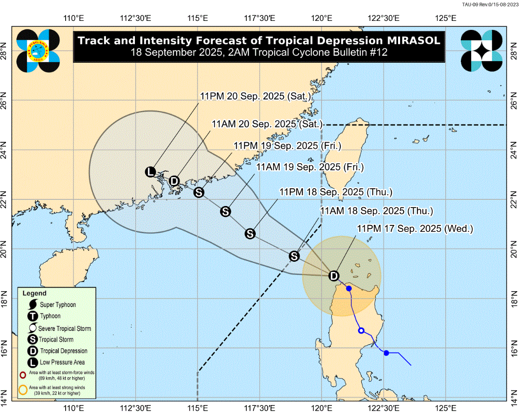
Tropical Depression Mirasol maintained its strength and is seen to bring rains as it moved over the coastal waters of Ilocos Norte, PAGASA said in its 2 a.m. tropical cyclone bulletin Thursday.
Based on the intensity forecast, Mirasol will likely intensify into a tropical storm within the next 12 hours. With this intensification, hoisting of Wind Signal No. 2 is possible over some portions of Northern Luzon, the weather bureau added.
Signal No. 1 is hoisted in the following areas in Luzon:
- Batanes
- Cagayan including Babuyan Islands
- the northern portion of Isabela (Santo Tomas, Santa Maria, Quezon, Roxas, Delfin Albano, San Pablo, Tumauini, Cabagan, Quirino, Mallig, Maconacon, San Mateo, Aurora, Cabatuan, San Manuel, Burgos, Gamu, Reina Mercedes, Luna, Ilagan City, Divilacan)
- Apayao
- Abra
- Kalinga
- Mountain Province
- the eastern and northern portions of Ifugao (Mayoyao, Hungduan, Aguinaldo, Banaue, Alfonso Lista, Hingyon)
- Ilocos Norte
- the northern and central portions of Ilocos Sur (Sinait, Cabugao, San Juan, Magsingal, Santo Domingo, Bantay, San Vicente, San Ildefonso, Santa Catalina, City of Vigan, Caoayan, Santa, Cervantes, Quirino, San Emilio, Gregorio del Pilar, San Esteban, Banayoyo, Burgos, City of Candon, Santa Lucia, Santiago, Lidlidda, Nagbukel, Suyo, Sigay, Galimuyod, Santa Cruz, Santa Maria, Narvacan, Salcedo)
The center of the tropical depression was estimated over the coastal waters of Pagudpud, Ilocos Norte 60 kilometers north northeast of Laoag City, Ilocos Norte.
It is moving north northwestward at 10 km/h with maximum sustained winds of 55 km/h near the center and gustiness of up to 75 km/h.
Nando
PAGASA said the other tropical depression inside the Philippine Area of Responsibility, Nando, is "less likely to directly affect the weather in the next 48 hours."
It added the onset of heavy rains due to the Southwest Monsoon and Nando is possible by Sunday, September 21 or Monday, September 22.
"Nando may potentially enhance the Southwest Monsoon as it approaches the landmass. Wind Signal No. 1 will be hoisted over Northern Luzon as early as Saturday, September 20, and the highest Wind Signal that may be hoisted throughout its passage is Wind Signal No. 5 considering that this tropical cyclone may reach super typhoon category," PAGASA said.
The center of Nando was estimated 1,140 km East of Southeastern Luzon and moving west northwestward at 15 kilometers per hour.
It has maximum sustained winds of 55 km/h near the center and gustiness of up to 70 km/h.
Nando entered PAR on Wednesday and is forecast to move generally northwestward over the Philippine Sea. Afterwards, it will turn west northwestward by Sunday towards extreme Northern Luzon.—LDF, GMA Integrated News
