

PAGASA warns public as Nando seen to become super typhoon by Monday
State weather bureau PAGASA on Friday warned the public of possible hazards and reminded them to prepare for the expected impact of Tropical Storm Nando, which may reach the super typhoon category by Monday.
“As early as now ay kumilos na. Make sure na ligtas ang kanilang mga tahanan at sundin ang maaaring aksyon na ipapairal ng kanilang mga lokal na leaders para maibsan, ma-minimize ang impacts nitong Nando,” PAGASA administrator Dr. Nathaniel Servando said at a press conference.
(As early as now, it has moved. Make sure all are safe and follow instructions from our local leaders to minimize the impact of Nando.)
“Ito'y may dala (na) panganib muli dahil sa malakas na hangin at malakas na pag-ulan na magdulot ng mga pagbaha, landslides, at storm surge sa mga dalampasigan,” he added.
(This brings danger due to its strong wind and heavy rainfall which could cause floods, landslides and storm surge in seashores.)
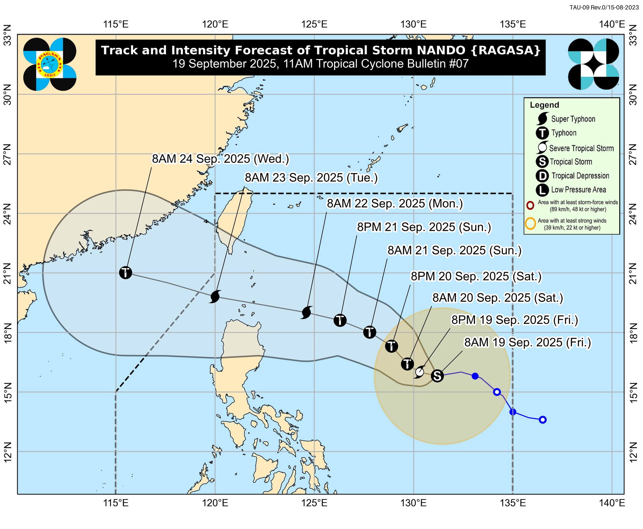
PAGASA weather specialist Benison Estareja said that as of 1 p.m., Nando was located 1,005 kilometers east of Central Luzon, packing maximum winds of 75 km per hour and gustiness of 90 kph.
The tropical storm was moving westward at 20 kph.
Winds
According to Estareja, Tropical Cyclone Wind Signal (TCWS) No. 4 and 5 may be raised over Batanes and Babuyan Islands
“Kung pagbabasehan po natin yung latest track, ito yung mga areas na posibleng magkaroon po ng Signals No. 4 and No. 5, yung southern portion of Batanes at yung Babuyan Islands,” he said.
(If we based it on the latest track, these are the areas which could possibly have Signals No. 4 and 5 — the southern portion of Batanes and Babuyan Islands.)
“Hindi rin natin iro-rule out na itong mga nasa northern part ng mainland Cagayan, kabilang na yung Santa Ana, Gonzaga, Aparri, Ballesteros. Yun yung mga lugar na maraming magkakaroon din ng malalakas na hangin at ulan na dala ng bagyong posibleng maging super typhoon by then,” he added.
(But we will not rule out those in the northern part of mainland Cagayan, including Sta. Ana, Gonzaga, Aparri, Ballesteros. These are the areas which could experience strong wind and heavy rainfall due to the possibility of [Nando] becoming a super typhoon by then.)
Meanwhile, TCWS No. 1 to 3 are expected over northern portion of Apayao, Ilocos Norte, Cagayan Valley, Cordillera Region, Ilocos Region, and Aurora.
Rains
For rainfall, over 200 millimeters of rainfall may be experienced over Cagayan, Batanes, Apayao, and Ilocos Norte, according to Estareja.
“Ine-expect din natin na magkakaroon ng significant na ulan dito po sa mga lugar, again na malayo po doon sa bagyo kabilang na yung Zambales, Bataan, Occidental Mindoro, Antique, Aklan, and Palawan. Maaaring humigit po sa 100 mm ang dami ng ulan kada araw,” he said.
(We also expect that these areas will have significant rainfall, including Zambales, Bataan, Occidental Mindoro, Antique, Aklan and Palawan. It's possible that rainfall will be more than 100 mm everyday.)
“Yung Metro Manila, posible rin po. Yung mga nearby areas pa dito sa may Central Luzon, Calabarzon, other parts of Northern Luzon pa, minimum of 50 mm per day po,” he added.
(It's also possible in Metro Manila. Nearby areas in Central Luzon, Calabarzon and other parts of Northern Luzon, about 50 mm per day.)
Storm surge
Estareja also warned of possible storm surge in Batanes, the northern coast of Cagayan, the northern coast of Ilocos Norte, and the eastern side of the Ilocos Region
“Ini-expect natin na magkakaroon talaga sa initial issuance pa lamang ng babala ng daluyong dito po sa may Batanes at sa may northern coast po ng Cagayan,” he said.
(We expect that there would be [a storm surge] in Batanes and the norther coast of Cagayan.) — RSJ, GMA Integrated News
