

Nando rapidly intensifies, 6 areas now under Signal No.2
Six areas are now under Signal No.2 as Typhoon Nando continues to strengthen as it approaches the northern part of Luzon, according to the state weather bureau on Sunday morning.
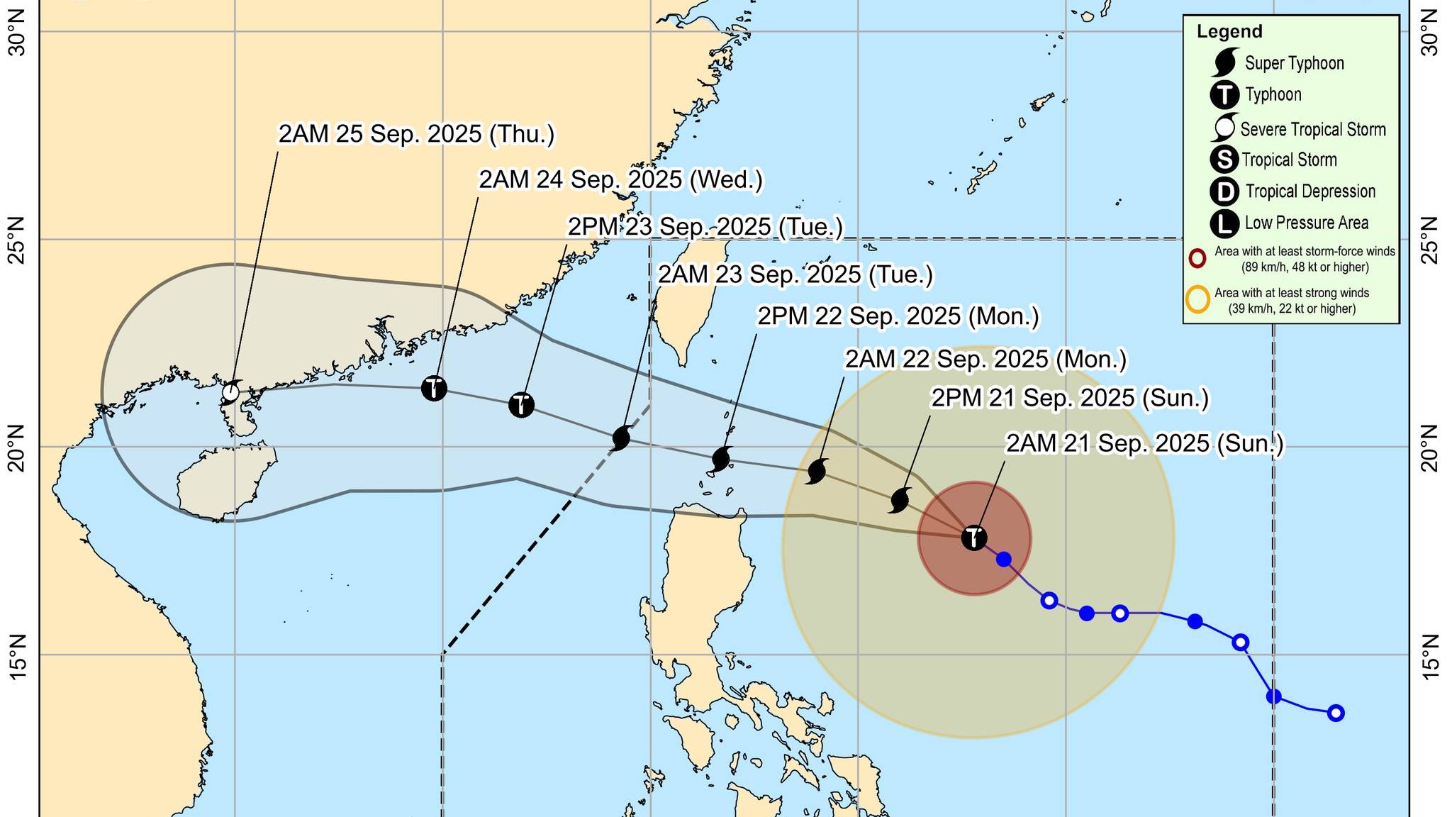
According to PAGASA's 5:00 a.m. tropical cyclone bulletin, the center of the eye of Typhoon Nando (International name Ragasa), was estimated based on all available data at 610 km east of Tuguegarao City, Cagayan.
Nando currently has maximum sustained winds of 175 km/h near the center, gustiness of up to 215 km/h, and central pressure of 935 hPa.
The typhoon is moving Northwestward at 15 km/h with "strong to typhoon-force winds extend outwards up to 530 km from the center" as per PAGASA.
The following areas are under Tropical Cyclone Wind Signal No.2 (TCWS No. 2) will experience wind speeds of 62 to 88 km/h in the next 24 hours:- Batanes
- Cagayan
- Babuyan Islands
- The northeastern portion of Isabela (San Mariano, Ilagan City, Tumauini, Cabagan, Palanan, Divilacan, Maconacon, San Pablo, Santa Maria, Santo Tomas, Delfin Albano)
- The eastern portion of Apayao (Luna, Santa Marcela, Pudtol, Flora)
- The eastern portion of Kalinga (Rizal)
Meanwhile, TCWS No.1 with wind speeds: 39 to 61 km/h are over the following locations:
- The rest of Isabela
- Quirino
- Nueva Vizcaya
- The rest of Kalinga
- The rest of Apayao
- Abra
- Mountain Province
- Ifugao
- Benguet
- Ilocos Norte
- Ilocos Sur
- La Union
- Pangasinan
- the northern portion of Zambales (Santa Cruz, Candelaria, Masinloc, Palauig)
- the northern and central portions of Nueva Ecija (Carranglan, Lupao, San Jose City, Pantabangan, Bongabon, Laur, Gabaldon, General Mamerto Natividad, Rizal, Llanera, Talavera, Science City of Muñoz, Santo Domingo, Talugtug, Palayan City, Cuyapo, Nampicuan, Guimba, Licab, Quezon, Aliaga, Cabanatuan City, Santa Rosa, Zaragoza, Jaen, San Leonardo, General Tinio, Peñaranda)
- the northern and central portions of Tarlac (San Jose, City of Tarlac, La Paz, Victoria, Gerona, Paniqui, Moncada, San Manuel, Anao, Ramos, Pura, Camiling, San Clemente, Mayantoc, Santa Ignacia)
- Aurora, and the northern and central portions of Catanduanes (Pandan, Caramoran, Bagamanoc, Panganiban, Viga, Gigmoto, San Miguel, Baras)
A heavy rainfall outlook is also up for Nando and the the Southwest Monsoon which could reach to as high as Wind Signal No. 5.
"Nando will begin to turn west northwestward today, moving towards Extreme Northern Luzon. On the forecast track, the center of NANDO may pass close or may make landfall over Batanes or Babuyan Islands between tomorrow (22 September) afternoon and evening. It may exit the Philippine Area of Responsibility by Tuesday (23 September) early morning," PAGASA said.
PAGASA said Nando may become a super typhoon today and "will continue to intensify before it approaches Extreme Northern Luzon."
"Considering these developments, the public and disaster risk reduction and management offices concerned are advised to take all necessary measures to protect life and property. Persons living in areas identified to be highly or very highly susceptible to these hazards are advised to follow evacuation and other instructions from local officials. For heavy rainfall warnings, thunderstorm/rainfall advisories, and other severe weather information specific to your area, please monitor products issued by your local PAGASA Regional Services Division," the agency said.
Meteorologists said "the Southwest Monsoon and the trough of NANDO will bring strong to gale-force gusts over the following areas (especially in coastal and upland areas exposed to winds" to the following areas:
• 21 Sept.: Metro Manila, Central Luzon (areas not under wind signal), CALABARZON, Bicol Region, MIMAROPA, Visayas, Northern Mindanao, Zamboanga Peninsula, Caraga, Davao Occidental, and Davao Oriental.
• Sept. 22 Sept.: Metro Manila, Central Luzon (areas not under wind signal), CALABARZON, Bicol Region, MIMAROPA, Visayas, Northern Mindanao, Caraga, Zamboanga Peninsula, BARMM, SOCCSKSARGEN, Davao Occidental, and Davao Oriental.
• Sept. 23: Metro Manila, Central Luzon (areas not under wind signal), CALABARZON, Bicol Region, MIMAROPA, Visayas, Northern Mindanao, Zamboanga Peninsula, and Dinagat Islands.
Coastal waters
PAGASA has issued a Gale Warning that is in effect over the northern and eastern seaboards of Northern Luzon.
For the next 24 hours, the agency said "Up to very rough, high, or very high seas over the following coastal waters" for the following coastal areas:
• Up to 11 m: The seaboards of Batanes and Babuyan Islands; the northeastern seaboard of mainland Cagayan
• Up to 8.0 m: The remaining seaboards of mainland Cagayan.
• Up to 5.5 m: The seaboard of Isabela
• Up to 4.5 m: The northeastern seaboard of Aurora; the northern seaboard of Ilocos Norte.
"Sea travel is risky for all types or tonnage of vessels. All mariners must remain in port or, if underway, seek shelter or safe harbor as soon as possible until winds and waves subside," PAGASA advised.
Up to rough seas over the following coastal waters were also in the forecast:
• Up to 3.5 m: The remaining seaboards of Aurora; the northern and eastern seaboards of Polillo Islands
• Up to 3.0 m: The remaining seaboard of Ilocos Norte; the northern and eastern seaboards of Catanduanes
"Mariners of small seacrafts, including all types of motorbancas, are advised not to venture out to sea under these conditions, especially if inexperienced of operating ill-equipped vessels", PAGASA said.
Up to moderate seas over the following coastal waters of up to to 2.5 m. are expected at the eastern seaboards of Albay and Sorsogon; the northern and eastern seaboards of Camarines Sur, Camarines Norte, and Northern Samar.
"Mariners of motorbancas and similarly-sized vessels are advised to take precautionary measures while venturing out to sea and, if possible, avoid navigation under these conditions," authorities warned.
The next tropical cyclone bulletin will be issued at 11:00 AM today. —RF, GMA Integrated News
