

Nando nears Babuyan Islands, life-threatening conditions imminent over N. Luzon
State weather bureau PAGASA said Monday morning that life-threatening conditions are imminent over the northern portion of Northern Luzon as Super Typhoon Nando approaches Babuyan Islands.
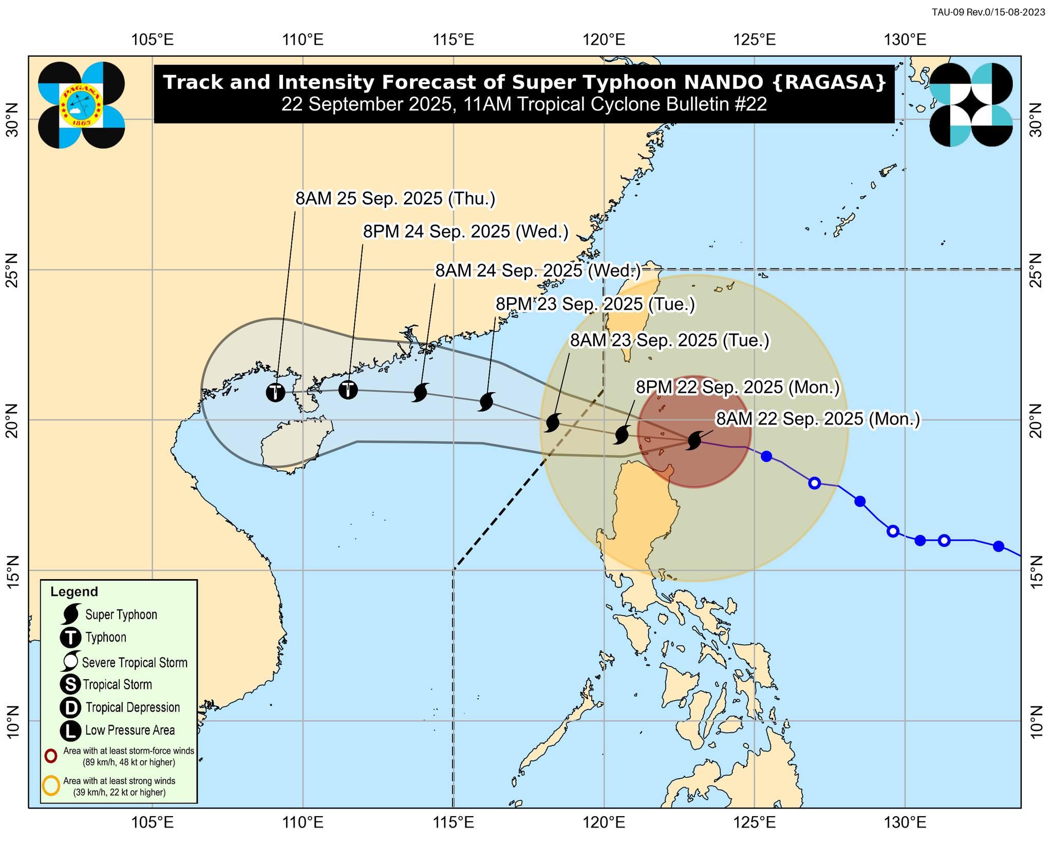
In its 11 a.m. tropical cyclone bulletin, PAGASA said the center of the eye of Nando was estimated at 110 km east of Calayan, Cagayan. It said strong to typhoon-force winds extend outwards up to 600 km from the center.
Nando is packing maximum sustained winds of 215 km/h near the center, gustiness of up to 265 km/h, and central pressure of 910 hPa. It is moving westward at 20 km/h.
PAGASA said the following tropical cyclone wind signals have been assigned:
Signal No. 5
- Babuyan Islands
Signal No. 4
- The southern portion of Batanes (Basco, Mahatao, Ivana, Uyugan, Sabtang),
- the northern of mainland Cagayan (Santa Ana, Santa Praxedes, Claveria, Sanchez-Mira, Pamplona, Abulug, Ballesteros, Aparri, Buguey, Santa Teresita, Gonzaga, Camalaniugan),
- the northern portion of Ilocos Norte (Pagudpud, Burgos, Bangui, Dumalneg, Adams)
Signal No. 3
- The rest of Batanes,
- the central portion of mainland Cagayan (Lal-Lo, Gattaran, Baggao, Alcala, Santo Niño, Lasam, Allacapan, Rizal, Amulung, Piat),
- the northern and central portions of Apayao (Flora, Santa Marcela, Pudtol, Luna, Calanasan, Kabugao), and
- the rest of Ilocos Norte
Signal No. 2
- The rest of mainland Cagayan,
- Isabela,
- the rest of Apayao,
- Abra,
- Kalinga,
- Mountain Province,
- Ifugao,
- the northern portion of Benguet (Mankayan, Buguias, Bakun, Kibungan),
- the northeastern portion of Nueva Vizcaya (Diadi),
- Ilocos Sur, and
- the northern portion of La Union (Sudipen, Bangar, Luna, Balaoan, Santol)
Signal No. 1
- Quirino,
- the rest of Nueva Vizcaya,
- the rest of Benguet,
- the rest of La Union,
- Pangasinan,
- Aurora,
- Nueva Ecija,
- Bulacan,
- Tarlac,
- Pampanga,
- Zambales, and
- the northern portion of Quezon (General Nakar) including Polillo Islands
Storm surge
PAGASA reiterated that there is a high risk of life-threatening storm surge with peak heights exceeding three meters within the next 24 hours over the low-lying or exposed coastal localities of Batanes, Cagayan including Babuyan Islands, Ilocos Norte, and Ilocos Sur.
Nando track and intensity
The state weather bureau said Nando will continue moving westward towards the Babuyan Islands. The center of Nando may pass close or may make landfall over Babuyan Islands between noon and early afternoon Monday.
It added Nando may maintain its strength or further intensify before its close approach to Babuyan Islands.
Nando may exit the Philippine Area of Responsibility by Tuesday morning.—AOL, GMA Integrated News
