

Super Typhoon Nando has 3 Luzon areas under Signal No. 4
Signal No. 4 is hoisted in three Luzon areas as Super Typhoon Nando continued to move away from the Babuyan Islands, PAGASA said late Monday evening.
Based on PAGASA's 11 p.m. bulletin, the following areas are:- Western portion of Babuyan Islands (Panuitan Isl., Calayan Isl., Dalupiri Isl.,Irao Isl.,Mabag Isl., Barit Isl., Fuga Isl.)
- Northwestern portion of Cagayan (Santa Praxedes, Claveria)
- Northern portion of Ilocos Norte (Pagudpud, Burgos, Bangui, Dumalneg, Adams)
Signal No. 3 is up in the following areas:
- Batanes
- The rest of Babuyan Islands
- Northern and central portions of Cagayan (Lal-Lo, Gattaran, Lasam, Allacapan, Ballesteros, Abulug, Aparri, Santa Teresita, Buguey, Camalaniugan, Alcala, Rizal, Santo Niño, Gonzaga, Pamplona, Sanchez-Mira, Santa Ana)
- Northern and central portions of Apayao (Flora, Santa Marcela, Pudtol, Luna, Calanasan, Kabugao)
- The rest of Ilocos Norte
Signal No. 2 is hoisted in the following areas:
- The rest of mainland Cagayan
- Northern portion of Isabela (Santo Tomas, San Mateo, Aurora, Santa Maria, Quezon, Roxas, Luna, Delfin Albano, San Pablo, Ilagan City, Tumauini, Cabagan, Reina Mercedes, San Manuel, Cabatuan, Quirino, Divilacan, Gamu, Mallig, Maconacon, Burgos)
- The rest of Apayao
- Abra
- Kalinga
- Mountain Province
- Ifugao
- Northern portion of Benguet (Mankayan, Buguias, Bakun, Kibungan)
- Ilocos Sur
- Northern portion of La Union (Sudipen, Bangar, Luna, Balaoan, Santol)
Signal No. 1 is up in the following areas:
The rest of Isabela
- Quirino
- Nueva Vizcaya
- The rest of Benguet
- The rest of La Union
- Pangasinan
- Aurora
- Nueva Ecija
- Bulacan
- Tarlac
- Pampanga
- Zambales
- Northern portion of Quezon (General Nakar), including Polillo Islands
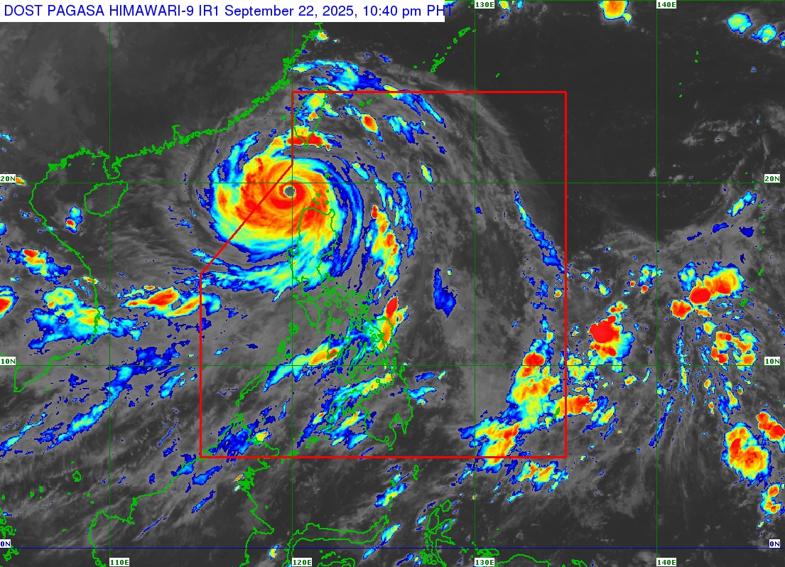
Nando was located 145 km west northwest of Calayan, Cagayan, carrying maximum sustained winds of 205 km/h near the center and gustiness of up to 285 km/h. It was traveling westward at 20 km/h.
PAGASA said a slight intensification is still not ruled out.
“Nevertheless, the super typhoon is forecast to begin weakening within the next 24 hours due to a marginally favorable environment that it will encounter over the West Philippine Sea,” PAGASA said.
It added that Nando would continue moving away from the Babuyan Islands on Monday night and is expected to exit the Philippine Area of Responsibility on Tuesday morning.
The state weather bureau also said there is a high risk of life-threatening storm surge with peak heights exceeding 3.0 m within the next 24 hours over the low-lying or exposed coastal localities of Batanes, Cagayan, including Babuyan Islands, Ilocos Norte, and Ilocos Sur.
Meanwhile, the Southwest Monsoon and the trough of NANDO will bring strong to gale-force gusts to Metro Manila, Central Luzon (areas not under wind signal), CALABARZON, Bicol Region, MIMAROPA, Visayas, Zamboanga Peninsula, and Dinagat Islands on Tuesday. –NB, GMA Integrated News
