

Opong maintains strength as it moves towards Eastern Visayas, Southern Luzon
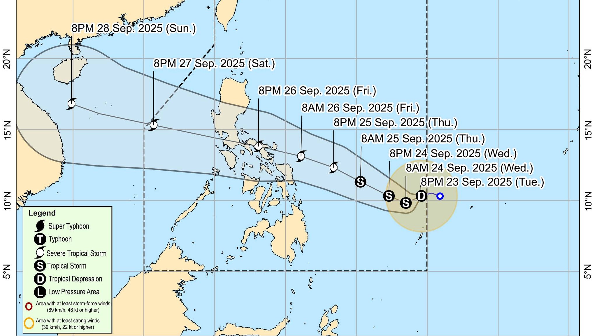
Tropical Depression Opong maintained its strength as it continued to move west southwest over the Philippine Sea towards Eastern Visayas and Southern Luzon on Tuesday evening, according to PAGASA.
In its tropical cyclone bulletin Issued at 11:00 p.m., the state weather bureau said the center of Opong was estimated at 980 km east of Northeastern Mindanao at 10 p.m.
“Opong is forecast to move generally west southwestward within the next 12 hours before turning west northwestward while approaching Eastern Visayas – Southern Luzon area. On the forecast track, Opong may make landfall over Bicol Region by Friday, September 26 and is expected to cross Southern Luzon area from Friday afternoon until Saturday morning.
PAGASA said Opong may exit the Philippine Area of Responsibility by Saturday evening or Sunday morning.
Opong has maximum sustained winds of 55 km/h near the center, gustiness of up to 70 km/h, and central pressure of 1004 hPa.
Its present movement is west southwestward at 15 km/h with strong winds extending outwards up to 280 km from the center.
No Tropical Cyclone Wind Signals (TCWS) are in effect but Wind Signal No. 1 will be hoisted over Eastern Visayas and Bicol Region as early as Wednesday, PAGASA said.
"The highest Wind Signal that may be hoisted throughout Opong’s passage is Wind Signal No. 3, considering that it may reach severe tropical storm category," it said.
For rainfall outlook, PAGASA said Opong “is less likely to directly affect the weather condition of the country in the next 24 hours” but the onset of heavy rains due to the storm is possible by Thursday onwards.
The Southwest Monsoon and possible Easterlies, both enhanced by Super Typhoon Nando and Opong will bring strong to gale-force gusts over the following areas (especially in coastal and upland areas exposed to winds):
- Tomorrow (24 September): Most of Luzon, Western Visayas, Surigao del Norte, and Dinagat Islands.
- Thursday (25 September): Batanes, Babuyan Islands, Cagayan, Ilocos Norte, Palawan, Siquijor, Camiguin, Surigao del Norte, Dinagat Islands, Davao Oriental, Davao del Sur, and Davao Occidental.
- Friday (26 September): Batanes, Babuyan Islands, Cagayan, Ilocos Norte, Siquijor, Northern Mindanao, Caraga, and Davao Region.
Coastal Waters
PAGASA said Opong “may bring moderate to rough seas over the coastal waters of Eastern Visayas and northeastern Mindanao starting Thursday afternoon. Gale Warning may be raised over Eastern Visayas and Bicol Region as early as Thursday afternoon in anticipation of rough to very rough sea conditions.”
Storm Surge
Due to the storm’s passage, meteorologists said “there is a potential risk of coastal flooding due to storm surge in low-lying coastal areas of Southern Luzon and Eastern Visayas.”
“Considering these developments, the public and disaster risk reduction and management offices concerned are advised to take all necessary measures to protect life and property,” PAGASA said.“Persons living in areas identified to be highly or very highly susceptible to these hazards are advised to follow evacuation and other instructions from local officials,” the agency added. —RF, GMA Integrated News
