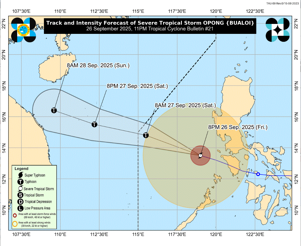
PAGASA lowers wind signals; Opong monitored over West PH Sea

State weather bureau PAGASA has lowered the tropical cyclone wind signals as severe tropical storm Opong continues its track over West Philippine Sea.
In its 11 p.m. cyclone bulletin, PAGASA said Signal No. 2 was hoisted over the northwestern portion of Occidental Mindoro (Paluan, Abra de Ilog, Mamburao) including Lubang Islands.
Signal No. 1 remains over the following Luzon areas:
- the central and western portions of Pangasinan (Basista, Lingayen, Villasis, City of Alaminos, Anda, Malasiqui, Urbiztondo, Bautista, Mangaldan, Mapandan, Burgos, Dagupan City, Bolinao, Aguilar, Alcala, Sual, Labrador, Bani, Santo Tomas, City of Urdaneta, Mangatarem, Mabini, San Carlos City, Manaoag, Binmaley, San Jacinto, Bugallon, Bayambang, Infanta, Agno, Calasiao, Santa Barbara, Dasol, San Fabian, Pozorrubio, Laoac, Binalonan, Asingan, Santa Maria, Balungao, Rosales)
- the southern portion of Aurora (Dingalan
- the western and southern portion of Nueva Ecija (Cuyapo, City of Gapan, San Leonardo, Santo Domingo, San Isidro, Zaragoza, Guimba, Aliaga, Science City of Muñoz, Cabanatuan City, Quezon, San Antonio, General Tinio, Santa Rosa, Nampicuan, Talugtug, Peñaranda, Jaen, Licab, Cabiao, Palayan City, General Mamerto Natividad, Talavera)
- Tarlac
- Zambales
- Bulacan
- Pampanga
- Bataan
- Metro Manila
- the northern and central portions of Quezon (Lucena City, Pagbilao, Infanta, Tiaong, San Antonio, Candelaria, Lucban, Sampaloc, Sariaya, City of Tayabas, Mauban, Dolores, General Nakar, Real)
- Rizal
- Laguna
- Cavite
- Batangas
- Oriental Mindoro,
- the rest of Occidental Mindoro
- and Palawan (El Nido, Taytay, Dumaran, Araceli) including Calamian Islands
The center of Opong was estimated at 260 kilometers West of Calapan City, Oriental Mindoro, moving west northwestward at 35 km/h with maximum sustained winds of 110 km/h near the center and gustiness of up to 135 km/h.
PAGASA said heavy rainfall, severe winds, and storm surge may still be experienced in localities "outside the landfall point and the forecast confidence cone" even as Opong continues to move away.
"On the track forecast, Opong will exit the Philippine Area of Responsibility (PAR) tomorrow (27 September) morning or noon. Outside the PAR region, Opong will move generally west northwestward towards northern Vietnam," it said.
"Opong may re-intensify into a typhoon within the next 12 hours as it moves over the West Philippine Sea," PAGASA added. —LDF, GMA Integrated News


