

Paolo slightly intensifies as 7 areas under Signal No. 2
Tropical Storm Paolo has slightly intensified while moving west northwestward over the Philippine Sea, the state weather bureau PAGASA said on Thursday.
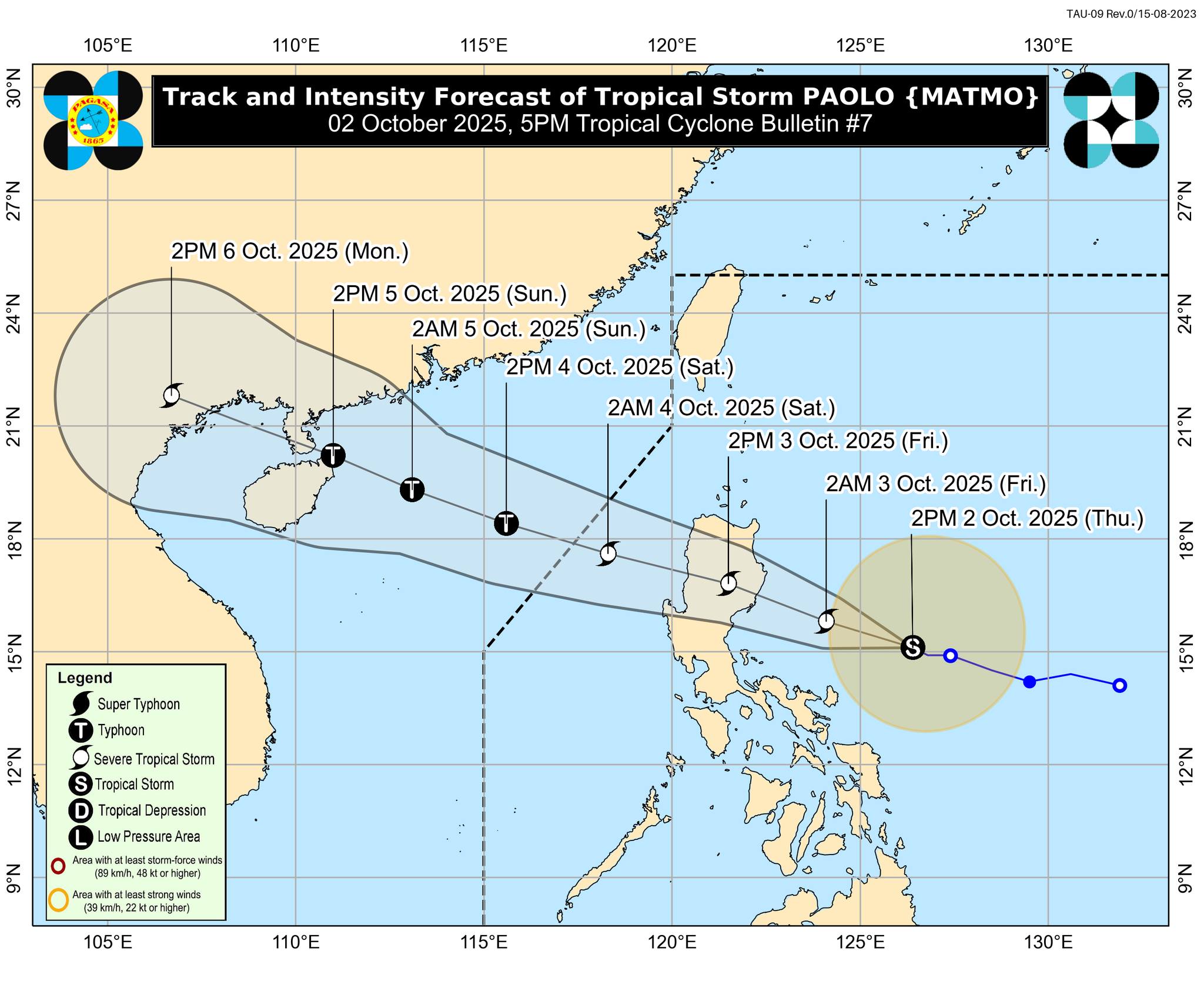
According to the 5 p.m. weather bulletin, the center of the storm was monitored 480 kilometers east of Infanta, Quezon or 480 kilometers east of Baler, Aurora.
It has maximum sustained winds of 85 km/h near the center and gustiness of up to 105 km/h. Paolo was moving west northwestward at 15 km/h, said PAGASA.
Tropical Cyclone Wind Signal No. 2 was hoisted over the following areas:
- Isabela
- the northern portion of Quirino (Maddela, Aglipay, Cabarroguis, Saguday, Diffun)
- the northern portion of Nueva Vizcaya (Diadi, Bagabag, Quezon, Solano, Villaverde, Ambaguio, Bayombong, Kasibu)
- Kalinga
- Mountain Province
- Ifugao
- the northern portion of Aurora (Dilasag, Casiguran, Dinalungan)
Meanwhile, the following areas are under Signal No. 1:
- Cagayan
- the rest of Quirino
- the rest of Nueva Vizcaya
- Apayao
- Abra
- Benguet
- Ilocos Norte
- Ilocos Sur
- La Union
- Pangasinan
- the northern portion of Zambales (Palauig, Masinloc, Candelaria, Santa Cruz)
- Tarlac
- Nueva Ecija
- the rest of Aurora
- the northern portion of Bulacan (Doña Remedios Trinidad, San Miguel, San Ildefonso, Norzagaray, San Rafael)
- the northern portion of Pampanga (Magalang, Arayat, Candaba, Mabalacat City)
- the northern portion of Quezon (General Nakar, Infanta) including Polillo Islands
- Camarines Norte
- the northern portion of Camarines Sur (Siruma, Tinambac, Lagonoy, Garchitorena, Caramoan, Goa, San Jose, Presentacion)
- Catanduanes
PAGASA said that the tropical storm may make landfall over southern Isabela or northern Aurora on Friday morning, October 3. Paolo is expected to further intensify while over the Philippine Sea and may reach severe tropical storm category on Thursday evening or early Friday.
PAGASA is also not ruling out the possibility of Paolo becoming a typhoon before landfall. But based on the intensity forecast, intensification into a typhoon is highly likely once Paolo emerges over the West Philippine Sea, the state meteorologists said.
Paolo may exit the Philippine Area of Responsibility by Saturday morning, October 4.
Based on the 24-hour weather forecast issued at 4 p.m., Paolo may bring stormy weather over Cagayan Valley, the Cordillera Administrative Region, Aurora, and Nueva Ecija.
Paolo will also bring rains with gusty winds over the Ilocos Region, the rest of Central Luzon, Quezon, Camarines Norte, Camarines Sur, and Catanduanes.
Further, the trough of the tropical storm may bring cloudy skies with scattered rains and thunderstorms over Metro Manila, the rest of Luzon, Eastern Visayas, and Western Visayas. —Vince Angelo Ferreras/VBL, GMA Integrated News
