

Signal No. 2 up over 4 areas as Ramil moves over the sea east of Sorsogon
Tropical Cyclone Wind Signal No. 2 was raised over four areas as Tropical Storm Ramil (international name: Fengshen) moves over the sea east of Sorsogon, PAGASA said in its 8 a.m. bulletin.
The areas under TCWS No. 2 are:
- Camarines Norte;
- Catanduanes;
- the northern portion of Camarines Sur (Tinambac, Siruma, Goa, San Jose, Lagonoy, Garchitorena, Caramoan, Presentacion); and
- Polillo Islands.
Areas under TCWS No. 2 will experience gale-force winds with speeds of 62 to 88 km/h in 24 hours, which may pose minor to moderate threat to life and property.
TCWS No. 1 meanwhile was raised over the following:
Luzon:
- Cagayan including Babuyan Islands;
- Isabela;
- Quirino;
- Nueva Vizcaya;
- Apayao;
- Abra;
- Kalinga;
- Mountain Province;
- Ifugao;
- Benguet;
- Ilocos Norte;
- Ilocos Sur;
- La Union;
- Pangasinan;
- Aurora;
- Nueva Ecija;
- the eastern portion of Bulacan (Doña Remedios Trinidad, Norzagaray, San Miguel, San Ildefonso, San Rafael, Angat);
- the eastern portion of Tarlac (Camiling, San Clemente, Santa Ignacia, Paniqui, Moncada, San Manuel, Anao, Ramos, Pura, Victoria, City of Tarlac, La Paz, Concepcion, Gerona);
- the eastern portion of Pampanga (Magalang, Arayat, Candaba);
- the northern and eastern portions of Quezon (Tagkawayan, Perez, Alabat, Quezon, Atimonan, Padre Burgos, Unisan, Gumaca, Plaridel, Agdangan, Pagbilao, Mauban, Calauag, Guinayangan, Lopez, Pitogo, Macalelon, General Luna, Catanauan, San Narciso, Buenavista, San Francisco, San Andres, Mulanay, General Nakar, Infanta, Real, Sampaloc) including Polillo Islands;
- the rest of Camarines Sur;
- Albay;
- Sorsogon;
- Burias Island; and
- Ticao Island.
Visayas:
- Northern Samar;
- the northern portion of Eastern Samar (San Policarpo, Arteche, Oras, Dolores, Maslog, Jipapad, Taft, Can-Avid); and
- the northern portion of Samar (Matuguinao, San Jose de Buan, Calbayog City, Gandara, Santa Margarita, Pagsanghan, San Jorge).
Areas under TCWS No. 1 may experience strong winds with speeds of 39 to 61 km/h in 36 hours, which may pose minimal to minor threat to life and property.
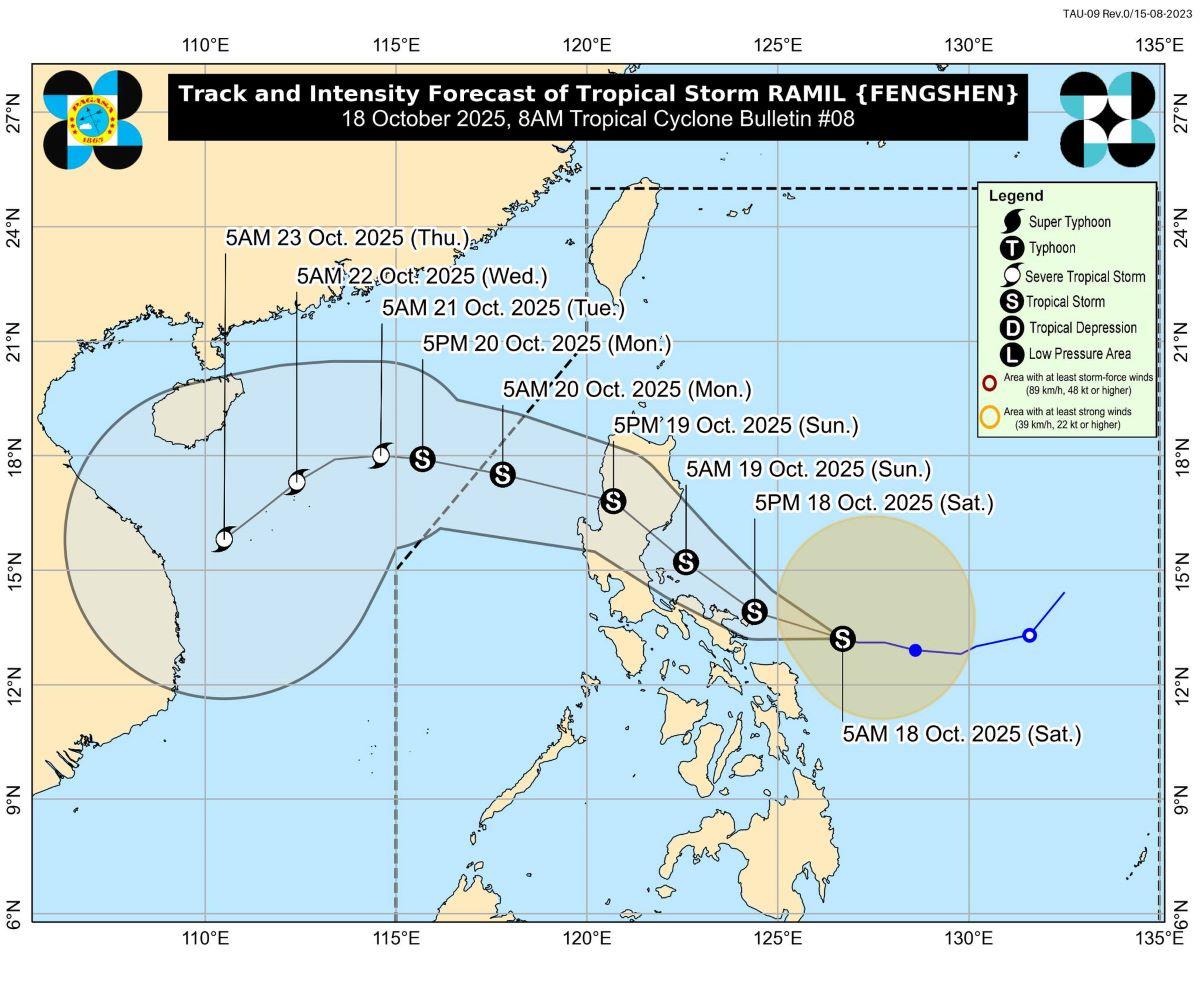
"On the forecast track, the center of RAMIL may make landfall or pass close to Catanduanes this afternoon or evening," PAGASA said.
"The possibility of reaching severe tropical storm category before landfall is not ruled out, the worst case scenario is Wind Signal No. 3," it added.
Location
At 7 a.m., Ramil's center was estimated to be located at 260 km east of Juban, Sorsogon.
Ramil has maximum sustained winds of 65 km/h near the center, with gustiness of up to 80 km/h, and central pressure of 1000 hPa.
The storm is moving west northwestward at 15 km/h.
From the center of the storm, strong to gale-force winds are extending outwards up to 400 km.
Rains
In its rainfall outlook, PAGASA said 100 to 200 mm of rains may be expected in Catanduanes, Sorsogon, Northern Samar, and Eastern Samar on Saturday.
Meanwhile, 50-100 mm of rainfall may fall over Quezon, Camarines Norte, Camarines Sur, Albay, Masbate, Samar, and Biliran.
Winds
Ramil's trough or extension and outer rainbands as well as the easterlies will bring strong to gale-force gusts on Saturday over the following areas not placed under TCWS, especiall in coastal and upland areas exposed to winds:
- Cagayan Valley;
- CALABARZON;
- Metro Manila;
- Ilocos Norte;
- Ilocos Sur; Marinduque;
- Mindoro Provinces; and
- Masbate.
Storm surge
PAGASA said there is minimal to moderate risk of storm surge with peak heights reaching 1.0 to 2.0 meters within 48 hours over the low-lying or exposed coastal areas in:
- Isabela;
- Aurora;
- Quezon;
- Marinduque;
- Camarines Norte;
- Camarines Sur;
- Catanduanes;
- Albay;
- Sorsogon;
- Masbate;
- Romblon;
- Northern Samar;
- Eastern Samar;
- Samar (Western Samar);
- Ilocos Norte;
- Ilocos Sur;
- La Union;
- Pangasinan; and
- Zambales.
Gale warning
Meanwhile, a gale warning was raised over the eastern seaboard of Southern Luzon.
Catanduanes, Camarines Sur (Caramoan, Garchitorena, Lagonoy, Tinambac, Siruma), and Camarines Norte (Mercedes, Basud, Daet, Vinzons, Talisay, Paracale, Capalonga, Jose Panganiban) will have up to very rough seas with waves possibly reaching up to 4.5 meters.
The same sea conditions may be expected in the eastern seaboards of mainland Cagayan and Isabela, and the eastern seaboards of Polillo Islands.
"Sea travel is risky for all types or tonnage of vessels. All mariners must remain in port or, if underway, seek shelter or safe harbor as soon as possible until winds and waves subside," PAGASA said.
Up to rough seas meanwhile will prevail over the coastal waters of:
- The northeastern seaboard of Aurora; the eastern seaboard of Babuyan Islands - up to 4.0 m
- The seaboards of Batanes; the rest of Aurora; the remaining seaboards of Cagayan including Babuyan Islands and Polillo Islands; the northern seaboard of Northern Samar - up to 3.0 m
"Mariners of small seacrafts, including all types of motorbancas, are advised not to venture out to sea under these conditions, especially if inexperienced of operating ill-equipped vessels" PAGASA said.
Up to moderate seas on the other hand may be expected over the following coastal waters:
- The seaboards of Ilocos Norte and Ilocos Sur; the eastern seaboards of Albay, Sorsogon, and Eastern Samar; the remaining seaboards of Northern Samar - up to 2.5 m
- The seaboard of La Union; the western seaboards of Pangasinan and Northern Samar; the eastern seaboards of the Dinagat Islands, Siargao and Bucas Grande Islands, Surigao del Sur, and the rest of mainland Quezon - up to 2.0 m
"Mariners of motorbancas and similarly sized vessels are advised to take precautionary measures while venturing out to sea and, if possible, avoid navigation under these conditions," PAGASA said.
Track, intensity outlook
"It must be emphasized that heavy rainfall, severe winds, and storm surge may still be experienced in localities outside the landfall point and the forecast confidence cone," PAGASA said.
Ramil's track may also still shift within the limit of the forecast confidence cone, it added.
Generally, the storm is forecast to move generally west northwestward toward Central and Southern Luzon.
After Ramil's landfall or passage near Catanduanes, it is expected to continue moving west northwestward "passing close to Vinzons, Camarines Norte and Polillo Islands tomorrow (19 October) morning," PAGASA said.
Ramil may make another landfall over Aurora or Isabela, it said.
Thereafter, it may traverse Northern and Central Luzon then emerge over the West Philippine Sea by Sunday afternoon or evening.
Ramil is expected to exit the Philippine Area of Responsibility on Monday morning.
Classes, preparations
Several local government units have declared a suspension of classes on Saturday, October 18, 2025 due to Ramil.
Catanduanes has made preparations ahead of Ramil's expected landfall on Saturday. Heavy equipment were brought to the Provincial Capitol for ready deployment in clearing operations. Sea travel has been suspended since Friday. Meanwhile, those in areas likely to be most affected by Ramil were advised to evacuate.
Residents in the coastal municipalities of Aurora meanwhile are preparing to evacuate in preparation for the possible landfall of Ramil on Sunday. —KG, GMA Integrated News
