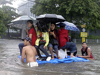
Tropical storm "Ondoy (Ketsana)" was over the South China Sea as it moved away from Philippine territory Sunday morning, but not before pummeling Metro Manila and other parts of the country.
Drop-off areas for 'Ondoy' victims
The government designated three drop-off points for relief goods intended for typhoon Ondoy's victims. These drop-off points were designated to make donations more "systematic," Teodoro said, adding that bottled water, clothes, blanket, and food will be accepted at these facilities.
See drop-off points here Four areas - Pangasinan, Zambales, Bataan, and Lubang Island- remained under Storm Signal No. 1, the Philippine Atmospheric Geophysical and Astronomical Services Administration said in its 5 a.m. advisory. "This disturbance is expected to enhance the Southwest Monsoon and bring occasional rains over the Western Sections of Central and Southern Luzon," it added. It added the rest of the Western section of Central Luzon and the Western sections of Southern Luzon and Visayas will have cloudy skies with scattered rainshowers and thunderstorms. Pagasa said the rest of the country will be mostly cloudy with scattered rainshowers and thunderstorms. As of 4 a.m., Pagasa said "Ondoy" was 290 km west of Iba, Zambales, with maximum winds of 95 kph near the center and gustiness of up to 120 kph. It was moving west-northwest at 24 kph and is expected to be 790 kms west-northwest of Iba, Zambales Monday. Meanwhile, Pagasa said moderate to strong winds blowing from the Southwest to Southeast will prevail over Northern Luzon and the rest of Central Luzon and coming from the Southwest over the rest of the country. Coastal waters throughout the archipelago will be moderate to rough. Pagasa also said the surge of the southwest monsoon is expected to affect the seaboards of Southern Luzon, Visayas and Mindanao. "Fishing boats and other small seacraft are advised not to venture out into the sea while larger sea vessels are alerted against big waves," it said.
- GMANews.TV 

