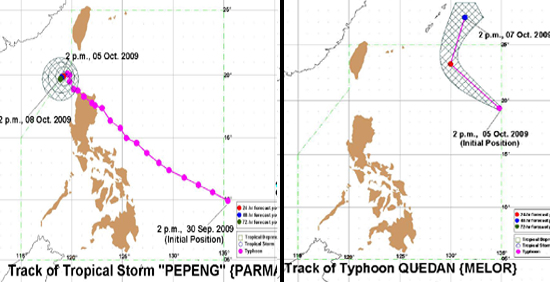
Tropical storm "Pepeng" (Parma) remained stationary over North Luzon and continues to threaten Ilocos Norte province, even as typhoon 'Quedan' (Melor) started heading for Okinawa, Japan. On Tuesday, Philippine Atmospheric Geophysical and Astronomical Services Administration (Pagasa) forecasters said Pepeng will likely stay a "few more days" in Philippine territory. "Mga ilang araw na lang (Just a few more days)," Pagasa forecaster Manny Mendoza said in an interview on dzBB radio, when asked how much longer Pepeng will stay in the country. Mendoza also stressed that Quedan is still too far to directly affect any part of the country even as it is already within the Philippine area of responsibility. Quedan is stronger than Pepeng.
 Pagasa's 8 a.m. update on Tuesday shows a satellite image of "Pepeng" (center-left) and "Quedan" (center-right), taken 11:30 p.m. Monday
 In its 5 a.m. advisory, Pagasa said Pepeng was 170 kilometers north northwest of Laoag City in Ilocos Norte as of 4 a.m. Tuesday. It was packing maximum sustained winds of 105 kph near the center and gustiness of up to 135 kph. "Extreme northern Luzon will experience stormy weather. The rest of northern Luzon will have rains and gusty winds with moderate to rough seas. Central Luzon will be mostly cloudy with scattered rainshowers and thunderstorms. The rest of the country will experience partly cloudy to cloudy skies with isolated rainshowers or thunderstorms," it said. Moderate to strong winds blowing from the southwest will prevail over the rest of the country with moderate to rough seas, it added. Pagasa said Pepeng is expected to remain almost stationary and be 170 km north northwest of Laoag City Wednesday morning, and 180 km north of Laoag City Thursday morning. By Friday morning, it is expected to be 190 km north northwest of Laoag City.
 Pagasa tracks the courses of "Pepeng" and "Quedan" Storm signals
 Ilocos Norte remains under storm signal No. 3, while Ilocos Sur, Abra, Apayao, Northern Cagayan, Calayan Group of Islands, Babuyan Group of Islands and Batanes Group of Islands were under storm signal No. 2. Under storm signal No. 1 are La Union, Benguet, Mountain Province, Ifugao, Kalinga, and the rest of Cagayan. Pagasa reminded residents in low-lying areas and near mountain slopes under storm signals to take precautions against flash floods and landslides. It added that those living along the coast in areas under signals No. 3 and 2 should be on alert against big waves generated by the tropical storm.
Quedan is strongerr Meanwhile, Pagasa said Quedan was located at 930 km east northeast of Basco, Batanes. Pagasa's 5 a.m. bulletin said Quedan had maximum sustained winds of 205 kph near the center and gustiness of up to 240 kph, and is forecast to move north northwest at 26 kilometers per hour. It forecast Quedan to be 860 km northeast of Basco, Batanes or 240 km east southeast of Okinawa, Southern Japan by Tuesday evening.
[See track map above] Meanwhile, Pagasa said strong to gale-force winds are expected to affect the seaboards of Central and Southern Luzon. "Fishing boats and other small seacraft are advised not to venture out into the sea while larger sea vessels are alerted against big waves," it said.
- with Sophia Dedace, GMANews.TV 

