We use cookies to ensure you get the best browsing experience. By continued use, you agree to our privacy policy and accept our use of such cookies. For further information, click FIND OUT MORE.
Make this your preferred source to get more updates from this publisher on Google.
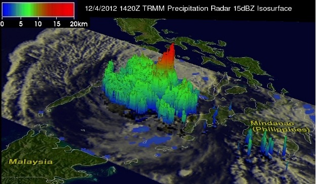
Pounding around 50 millimeters of rain down on Mindanao every hour until it eased off as it crossed the country on its way to the West Philippine Sea, Typhoon Pablo has a similar recorded precipitation level to two of the worst tropical cyclones to hit the country in recent years, Sendong and Ondoy. Tropical Storm Sendong dumped rain at over 50 mm/hr in Mindanao almost exactly one year ago. Tropical Storm Ondoy, which battered Metro Manila and neighboring provinces in September 2009, had a recorded rainfall rate of 56.83 mm/hr. According to NASA's Tropical Rainfall Measuring Mission (TRMM), Pablo also carried rain amounting to 85 mm/hr in and around its eye on Dec. 4, right before it made landfall in Mindanao. "This TRMM pass [see image below] showed that Bopha still had good organization but Mindanao's rugged terrain had taken its toll," TRMM reported.
NASA's Tropical Rainfall Measuring Mission's image of Typhoon Pablo (Bopha). Image from NASA TRMM
When NASA's satellite took images on Typhoon Pablo again, it reported, "[t]he heaviest rainfall was falling from northeast to southeast of the center, occurring at a rate of 50 millimeters per hour." "The storm's center was still well-defined, and there were still bands of thunderstorms feeding into the center, but the banding decreased on the eastern side of the storm," NASA said in a separate report. Earlier Wednesday morning, Typhoon Pablo made landfall for the third time in the country, this time in northeastern Palawan, notably weaker but still bringing with it strong winds and heavy rains. Record holder Of the hundreds of tropical cyclones to hit the Philippines in the last 15 years, only six made landfall in Mindanao, making the back-to-back onslaughts of Tropical Storm Sendong and Typhoon Pablo a rarity—even more so, according to data from the US Navy and Air Force Joint Typhoon Warning Center, as on average only one tropical cyclone every 10 years hits Mindanao in December. PAGASA also said that with maximum sustained winds of 185 kph, Pablo is the strongest typhoon to hit Mindanao in two decades. Accumulated rainfall comparisons In a Manila Observatory study, Cagayan de Oro, one of the cities struck by Sendong in 2011, had a total one-day rainfall amount of 180 mm, higher than the area's average monthly amount of rainfall for December of 117 mm. The 24-hour accumulated rainfall on Sept. 26, 2009 when Ondoy hit Metro Manila and adjacent provinces was 455 mm, according to PAGASA Science Garden's records. On the other hand, the "nameless deluge" that hit Metro Manila in August of this year had an even greater amount of rainfall, dumping 687 mm on the National Capital Region over a 48-hour period from Aug. 6 to 7, the peak of the southwest monsoon's devastation. The US' National Oceanic and Atmospheric Administration (NOAA) has estimated Typhoon Pablo's total accumulated rainfall between 200 and 250 mm. Pablo's current location In its 5 p.m. update, PAGASA said that as of 4 p.m., Pablo is 110 km northwest of Roxas, Northern Palawan, moving west-northwest at 15 kph with maximum sustained winds of 120 kph near the center and gustiness of up to 150 kph. It is forecast to be 510 km West of San Jose, Occidental Mindoro by Thursday afternoon and 700 km West of Subic, Zambales and outside the Philippine Area of Responsibility (PAR) by Friday afternoon. Northern Palawan and the Calamian Group of Islands are currently under Storm Signal No. 3, with the rest of Palawan under Signal No. 2. Occidental Mindoro is at Signal No. 1. — BM, GMA News