

ADVERTISEMENT
Filtered By: Topstories
News
PAGASA: 'Pablo' weakens into tropical storm, moving out of PHL
+
Make this your preferred source to get more updates from this publisher on Google.
After causing more than 300 deaths, cyclone Pablo (Bopha) weakened into a tropical storm early Thursday and has started moving away from the Philippines, state weather forecasters said.
PAGASA forecaster Chris Perez also said Tropical Storm Pablo has accelerated and may be out of the Philippine Area of Responsibility (PAR) by Friday.
"Sa ngayon bahagyang bumilis ang kilos ni Pablo. Kung magpapatuloy sa pace ng pagkilos inaasahan natin bukas na umaga ito tuloy lalabas sa PAR (On Thursday morning, Pablo has accelerated. At its present speed, we expect it to exit the Philippine Area of Responsibility by Friday morning)," he said in an interview on dzBB radio.
He said there is very little chance the tropical storm may recurve and head back toward Luzon. "Based on projections, Pablo will be out of the PAR by Saturday. For today, stormy weather will continue in Palawan but expect improving weather as Pablo moves farther away while Mindoro provinces will have rains with gusty winds. The rest of the country including provinces devastated by Pablo will have partly cloudy skies with rainshowers and thunderstorms," said GMA resident meteorologist Nathaniel "Mang Tani" Cruz. "Up north, Cagayan Valley and the Cordillera region will experience cloudy skies and light rains due to the prevailing northeast monsoon," he added.
Perez added areas affected by the cyclone can expect "gradually" improving weather this weekend.
"May (There will be) gradual improvement of weather conditions this weekend," he said.
PAGASA's 5 a.m. advisory said that as of 4 a.m., Tropical Storm Pablo was estimated at 350 km west of Coron, Palawan, with maximum sustained winds of 115 kph near the center and gustiness of up to 145 kph.
It was moving west-northwest at 13 kph and is expected to be 650 km west of Metro Manila or outside the Philippine Area of Responsibility by Friday morning.
Only the Calamian Group of Islands remained under Storm Signal No. 1. 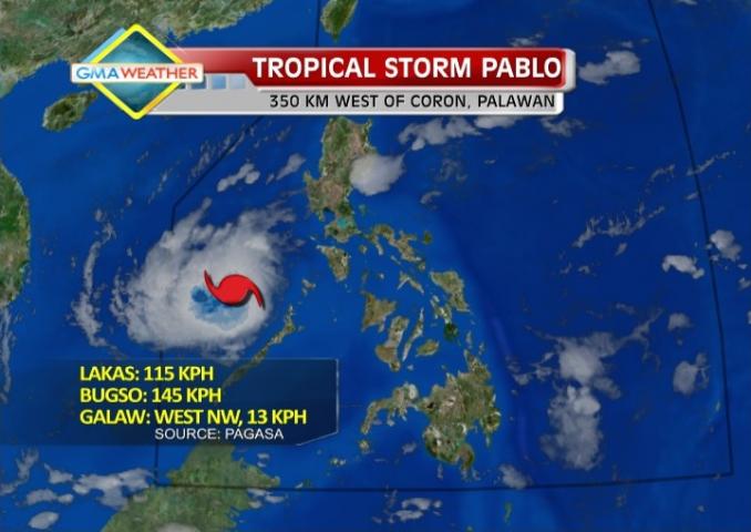
Satellite image at 7 a.m., Dec. 6
However, PAGASA noted Pablo may still bring some 10 to 18 mm per hour (heavy to intense) of rain from within its 350-km diameter.
It also advised fishing boats and other sea vessels not to venture out into the seaboards of Northern and Central Luzon and the eastern seaboard of Southern Luzon.
This is due to strong to gale force winds associated with the surge of the northeast monsoon enhanced by Tropical Storm Pablo.
Outlook as Pablo exits
PAGASA said Calamian Group of Islands will have rain with gusty winds with moderate to rough seas.
Caraga and Davao Regions will be cloudy with light to moderate rainshowers or thunderstorms while Metro Manila and the rest of Luzon will have cloudy skies with occasional light rain.
The rest of the country will be partly cloudy with brief rain showers or thunderstorms.
Moderate to strong winds blowing from the northeast to east will prevail over Northern and Central Luzon and coming from the east to southeast over the rest of the country.
The coastal waters along these areas will be with moderate to rough seas. — ELR, GMA News
