
How 1734 Murillo Velarde map serves as living document of Philippine territory
The Alliance Française de Manille on Friday launched an exhibition featuring rare maps from the 17th to 19th centuries and the Murillo Velarde 1734 Map, known as the "Mother of all Philippine Maps."
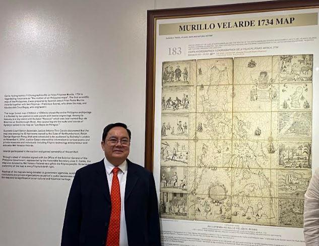
Titled "Scarborough Shoal and the Spratlys in Ancient Maps: An Exhibition," it featured the map collection of retired Supreme Court Associate Justice Antonio Carpio, and the Murillo Velarde 1734 Map, acquired by Filipino businessman Mel Velasco Velarde at a Sotheby's auction in London in 2012.
Velarde said that the "Mother of all Philippine Maps" was used at the arbitration tribunal to back up the Philippines' right and ownership over the Scarborough Shoal in the West Philippine Sea.
This is the first map that gave a name to Scarborough Shoal, or "panacot" in Tagalog, which means danger.
"I'm not just lending the map to the institution, I'm donating it to the government permanently as long as you will give it a permanent place," Velarde said, adding that he is very honored to participate in the exhibit, donating the official replica.
Velarde said Carpio encouraged him to bid for the map for it to be displayed in a public museum in the Philippines.
Carpio, also a guest of honor at the exhibit, discussed the importance of the ancient maps in Philippine history and in proving our territory.
"This is the Mother of all Philippine Maps because this is a living document. It determines Philippine territory today. You cannot determine Philippine territory without reference to this map," Carpio said.
"We have to go back to that map to determine the islands belonging in the Philippine archipelago. There's no other map," he added.
"That's why we have to have a copy of this map in the national library so that students, will go there and see that Scarborough Shoal is part of part of the Philippines," Carpio said.
The exhibit will run from April 21 to May 20, 2023, at the Alliance Française de Manille in Makati City.
It was organized by Alliance Française de Manille, the Asian Institute of Journalism and Communication (AIJC), and the Institute for Maritime and Ocean Affairs.
Carta Hydrographica Y Chorographica De La Yslas Filipinas, first published in Manila in 1734, is regarded by historians as the "Mother of all Philippine Maps" made by the Spanish Jesuit Friar Pedro Murillo Velarde with two Filipinos, Francisco Suarez, who drew the map, and Nicolas de la Cruz Bagay, who engraved it.
Velarde believes that ownership of the map is every Filipino's birthright, as he donated the map to the government as a gift to the Filipinos.
Meanwhile, several replicas are continuously being donated by Velarde to various government agencies, academic institutions, and private organizations as part of a national public awareness campaign on the map and its significance to Philippine cultural heritage.—LDF, GMA Integrated News
