

Why is Sierra Madre called the backbone of Luzon?
The Sierra Madre mountain range, the reputed "backbone of Luzon" for its ability to decrease the strength of tropical cyclones crossing the major island, again hit the headlines and the social media after its impact on Super Typhoon Uwan.
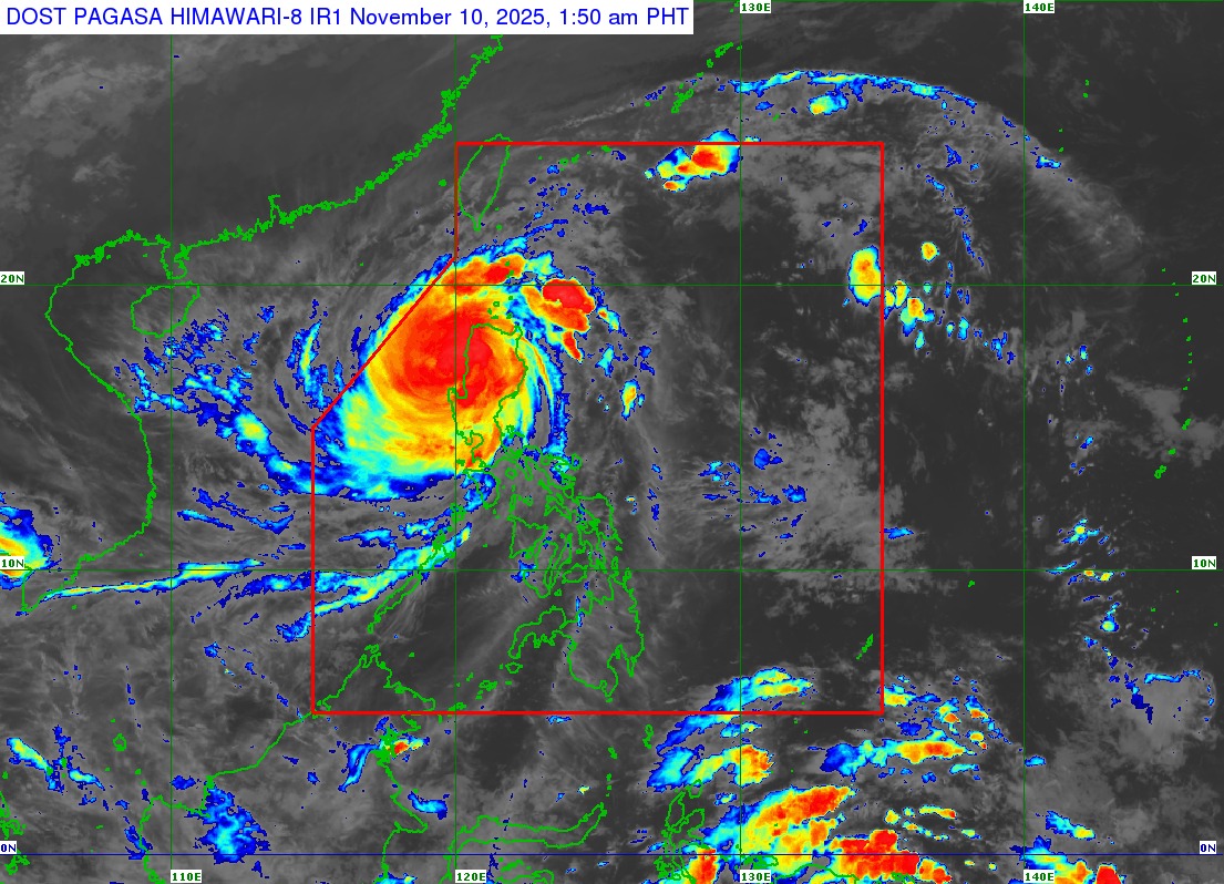
As Uwan (Fung-wong) made landfall in Luzon on Sunday night, satellite imagery showed how the Sierra Madre apparently disrupted the eye of the storm, making people recognize anew the mountain range’s presence as the country’s natural barrier.
As of Monday, November 10, at least two people were reported dead, and 1.4 million people or 426,000 families were preemptively evacuated due to Uwan. The super typhoon also caused infrastructure damage and power outages, and affected agriculture and livestock in certain areas.
According to PAGASA, the center of the eye of Uwan made landfall over Dinalungan, Aurora at 9:10 p.m. on Sunday.
After Uwan’s landfall, the state weather bureau said that it would cross the mountainous terrain of Northern Luzon and emerge over Lingayen Gulf or over the coastal waters of La Union or Ilocos Sur, emphasizing that Uwan's interaction with the terrain would cause it to “weaken significantly.”
Uwan weakened into a typhoon category as of early Monday morning, with Filipinos thanking the Sierra Madre—the Philippines’ longest mountain range.
But why is the Sierra Madre called the “backbone” of Luzon?
The Sierra Madre mountain range is approximately 540 kilometers long, stretching along the eastern portion of Luzon island from Cagayan province to Quezon province. In the northern part of the range lies the Northern Sierra Madre Natural Park which is also considered the largest protected area in the Philippines.
When viewed on a map, the Sierra Madre resembles a huge spine or a human backbone. Beyond that, it is often identified as Luzon’s backbone as it naturally acts as a barrier against typhoons hitting the country's northeast portion.
According to the Department of Environment and Natural Resources (DENR), the Sierra Madre stands as the country’s “shield” as it “tempers the force of typhoons, secures water for communities, and shelters rich biodiversity.”
The Department of Science and Technology (DOST) also recognized Sierra Madre’s ability to weaken or slow down winds carried by typhoons, particularly in the northeastern part of the country.
However, the agency stressed that the mountain range does not provide complete protection against the severe effects of typhoons, especially the strong ones.
The DOST, in its social media pages, shared a 2023 study by Dr. Gerry Bagtasa at Dr. Bernard Alan Racoma, which explains the mitigating effects of Sierra Madre and the ways to conserve the mountain range.
Results of the study showed that the Sierra Madre is an “effective barrier for the Cagayan Valley, as it reduces both wind exposure and basin-wide rainfall.” Regardless, the region remains vulnerable to extreme tropical cyclones.
Meanwhile, in other areas such as Metro Manila, the study noted that the increase of 25% to 55% in rainfall threat due to the slopes of Sierra Madre “will most likely compensate” for the reduced 3% to 8% wind exposure.
But aside from Sierra Madre, it is important to note that community efforts and preemptive evacuation also greatly helped in saving lives during the onslaught of typhoons in the country.
President Ferdinand "Bongbong" Marcos Jr. even lauded as "a difference-maker" the preemptive evacuation done by the local government units in the areas on the path of Super Typhoon Uwan.
Uwan is expected to exit the Philippine Area of Responsibility (PAR) by late Monday night or early Tuesday morning, but could re-enter by Wednesday evening as it moves toward Taiwan and the Ryukyu Islands, eventually weakening into a remnant low by Friday. –NB, GMA Integrated News
