ADVERTISEMENT
LIVE
Filtered By: Topstories
News

LIVE UPDATES: Habagat and its effects on Sunday, August 9, 2026


+
Add GMA on Google
Make this your preferred source to get more updates from this publisher on Google.
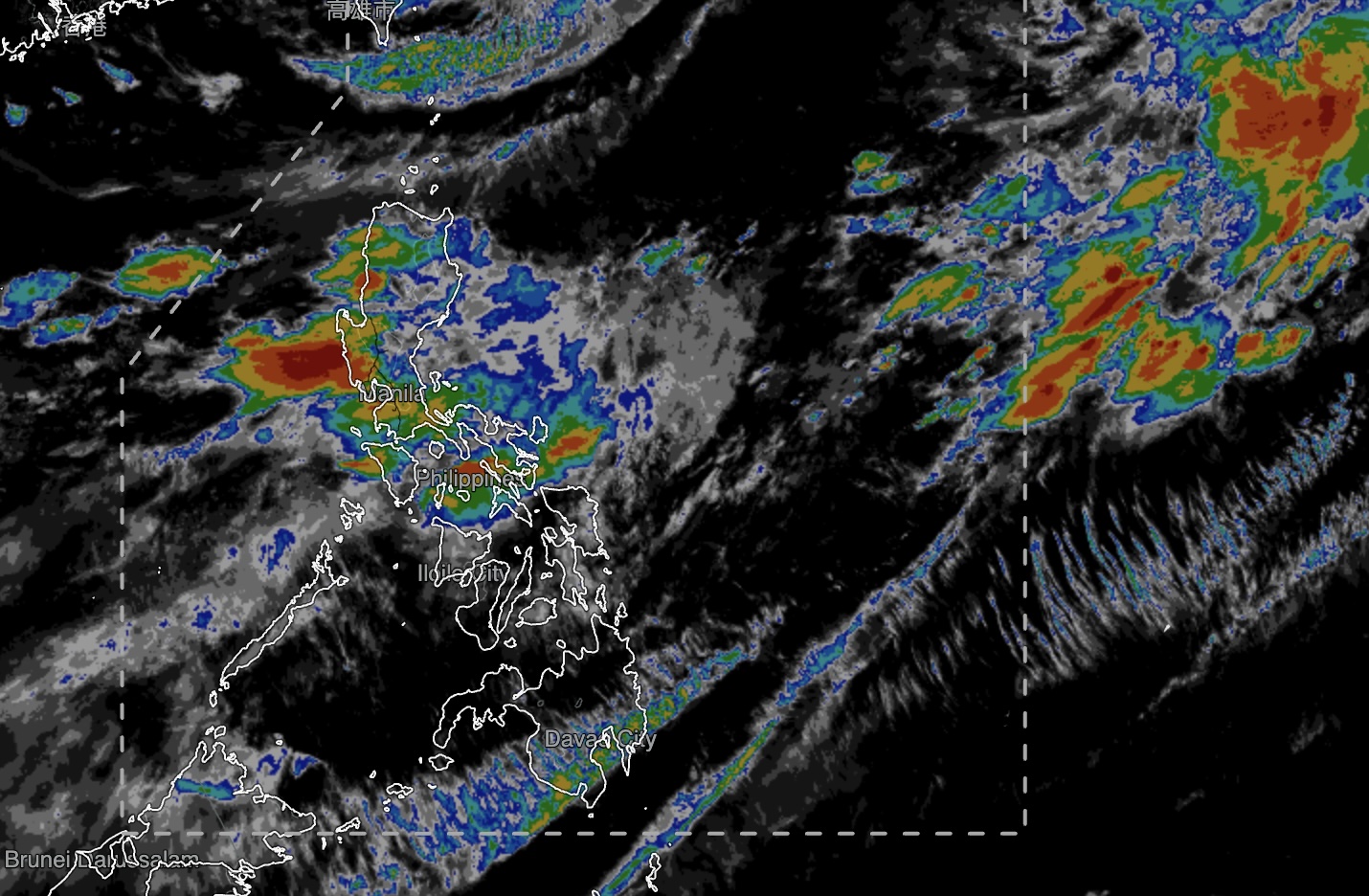
Habagat to bring rains over Metro Manila, parts of Luzon, Visayas
Auto-refresh

La Mesa Dam breaches critical level amid Habagat rains

The water level at La Mesa Dam in Quezon City breached the critical level on Sunday amid heavy rains caused by the Southwest Monsoon (Habagat).

Data from PAGASA showed that the water level was at 79.77 meters as of 10:20 a.m. on Sunday, August 9, 2026.

The dam's critical level is 79.50 meters while its spilling level is at 80.15 meters.

Should water be released or spill from the dam, low-lying areas and barangays along the Tullahan River, from Quezon City, Valenzuela City, Caloocan City, Malabon City, and Navotas.

The public were advised to stay alert and prepared for the continued rise of water in the Tullahan River. —KG, GMA News

Marikina River at 2nd alarm as water rises due to heavy rains from Habagat

Local authorities raised the second alarm as the water level at Marikina River reached 16.0 meters on Sunday morning.

The second alarm was raised at 10:56 a.m., according to the Marikina City Public Information Office.

Under the city's alert system, first alarm means residents should “prepare” as the water reached 15 meters above sea level.

Third alarm means “force evacuation” is implemented as the water reaches 18 meters.

Local authorities earlier raised the first alarm at 9 p.m. on Saturday as the water level reached 15.3 meters amid heavy rains.

The Southwest Monsoon will continue to bring occasional rains over Metro Manila on Sunday, PAGASA said.

The state weather bureau warned of possible flash floods or landslides due to moderate to heavy rains. —KG, GMA News

Habagat, high tide cause water levels to rise in Bulacan coastal areas

The heavy rains brought by the Southwest Monsoon (Habagat) and the high tide this weekend have caused water levels to rise and cause flooding in the coastal areas of Bulacan.

Retired Colonel Manuel Lukban, head of Bulacan Disaster Risk Reduction and Management Office, on Sunday said that high tide is common in the coastal areas even without rains.

As of 6 a.m., the water level in Bulacan's coastal areas is at past four feet due to the high tide.

"Isa sa mga factor na mino-monitor natin nang lubos ay ang pagkakaroon namin ng high tide mga bandang 6 (a.m.) kanina. Ang lebel po ay nasa 4.8 feet po. So ibig sabihin, with or without ulan, mataas ang lebel ng tubig sa ating mga coastal areas," he told Super Radyo dzBB in an interview.

(One of the factors we are closely monitoring is the high tide we had around 6 o'clock earlier. The level was at 4.8 feet. So that means, with or without rain, the water level in our coastal areas is high.)

The coastal areas are in Hagonoy, Bulakan, Paombong, parts of Marilao, Obando, and Meycauayan.

"Ito pong sinasabi nating coastal areas, ito po ang Hagonoy, Bulakan, Paombong, area ng Marilao at Obando at Meycauayan. May kataasan ang tubig nila doon sa mga parteng coastal areas na minomonitor natin, na masasabi nating halo na ng Habagat at high tide," Lukban added.

(These coastal areas we're referring to—Hagonoy, Bulakan, Paombong, areas of Marilao, Obando, and Meycauayan—have high water levels in those monitored coastal parts, which we can say is a combination of Habagat and high tide.)

For instance, in some barangays in Hagonoy like Santa Ana and San Miguel, the high tide is at around two to three feet. But the water level is expected to subside by noon.

"Sa oras na ito ay may kataasan ang tubig, nasa bandang 4 feet, ang high tide po kasi...Sa ibang barangay naglalaro ng two to three feet. Pero inaasahan natin na magsa-subside ito ng bandang patanghali," said Lukban.

(At this hour, the water is quite high, around 4 feet, because of the high tide... In other barangays, it ranges between two to three feet. But we expect this to subside towards noon.)

Several areas in the country were flooded due to the rains brought by Habagat.

According to PAGASA's 4 a.m. weather forecast, Habagat will continue to bring rains over Metro Manila and several parts of Luzon and the Visayas on Sunday. —Vince Angelo Ferreras/KG, GMA News

What should you do when there is a rockslide or landslide?

During the rainy season,rockslides and landslides are real dangers to some communities. Here are some safety tips in case they occur in in your area. 

WALANG PASOK: Class suspensions for Monday, August 10, 2026

Classes for Monday, August 10, 2026, have been suspended in some areas and schools due to the bad weather caused by the Southwest Monsoon (Habagat).

Below are the class suspensions for Monday, August 10, 2026:

Abra - no classes in all levels, public and private, including work in all government offices

University of Santo Tomas - no face-to-face classes, all levels; Enriched Virtual Mode of Instruction to be implemented

Refresh this page for updates. —KG, GMA Integrated News

LIST: Flooded areas in Metro Manila due to Habagat-caused rains

Some areas in Metro Manila were flooded due to the continuous rainfall from the Southwest Monsoon (Habagat) on Sunday, August 9, 2026.

Here is the list of flooded areas as of 8:20 a.m., according to the Metropolitan Manila Development Authority (MMDA):

QUEZON CITY
- Edsa P. Tuazon tunnel NB - Gutter deep, Passable to all types of vehicles

LAS PIÑAS CITY
- Alabang Zapote Junction, Las Piñas City - Knee deep, Not passable to light vehicles
- Marcos Alvarez Road, Las Piñas City Wonderland to Savemore - Knee deep, Not passable to light vehicles

PARAÑAQUE CITY
- Ninoy Aquino Oyster Plaza, Parañaque- Half tire deep, Not passable to light vehicles
- Dr. A. Santos Ave. in front of SM Sucat NB Brgy, San Dionisio- above gutter deep, Passable to all types of vehicles
- Dr. A. Santos Ave. in front of SM Sucat SB Brgy, San Dionisio, Not Passable to all types of vehicles

PASAY CITY
- Roxas Heritage intersection - Gutter Deep, Passable to all types of vehicles
- Roxas Edsa intersection - Gutter Deep, Passable to all types of vehicles

MANDALUYONG CITY
- F. Ortigas cor Boni Ave. - Gutter Deep, Passable to all types of vehicles

MALABON CITY
- M.H. Del Pilar St. Maysilo - Half Gutter, Passable to all types of vehicles
- M.H. Del Pilar St. (Tatawid) Santulan- Half Gutter, Passable to all types of vehicles
- Don Basilio Bautista Hulong Duhat - Gutter Deep, Passable to all types of vehicles

CITY OF MANILA
- Roxas Pedro Gil service road - Gutter Deep, Passable to all types of vehicles
- UN Ave. Taft - Gutter Deep, Passable to all types of vehicles

The following local government units also released separate flood advisories:

QUEZON CITY
(as of 6:30 a.m.)
- 29, 42, 48 Kapiligan (looban, tabing-ilog), Barangay Doña Imelda - waist deep (37 inches)
- Araneta - Baloy, Barangay Doña Imelda - half-knee deep (10 inches)
- Zamboanga St. Kanan Dulo near Bai Compound, Brgy. Vasra - gutter deep (8 inches)
- Araneta - E. Rodriguez, Brgy. Doña Imelda - gutter deep (8 inches)
- Sto. Domingo corner Calamba, Barangay Sto. Domingo (Matalahib) - gutter deep (8 inches)
- Samat corner Don Jose - gutter deep (8 inches)
- NS Amoranto corner Don Jose - gutter deep (8 inches)

CITY OF MANILA
(as of 7:13 a.m.)
- Taft Avenue corner Quirino Avenue - Gutter Deep
- Bocobo Robinsons - Remedios Circle- Gutter Deep

VALENZUELA CITY
(as of 5:55 a.m.)
- MacArthur Highway in front of Toyota Dalandanan - 3-4 inches (Surface Water) - passable to all types of vehicles
- MacArthur Highway in front of Our Lady of Fatima Hospital -3-4 inches (Surface Water) - passable to all types of vehicles

- Dalandanan Market - 8 inches, gutter deep
- G. Lazaro Dalandanan cor. MacArthur Highway - 8 inches, gutter deep
- Along G. Lazaro Dalandanan - 8 inches, gutter deep
- G. Lazaro Dalandanan cor. VCEH - 1-2 inches, surface water
- Bartolome Malanday - 3-4 inches, surface water
- I. Fernando Malanday - 1-2 inches, surface water
- MacArthur Highway Cor. T. Santiago Veinte reales - 8 Inches, gutter deep
- Boundary Canumay East to Lawang Bato- 4-6 inches, surface water

PASIG CITY
(as of 6:20 a.m.)

Brgy. Dela Paz
1. Kabutihan Rd
Water Level: 60.96cm (24 inches)
Not passable to motorcycles and cars (sedan)

2. Katiparan Road
Water Level: 45.72cm (18 inches)
Not passable to motorcycles and cars (sedan)

3. K115 St.
Water Level: 36.58cm (14 inches)
Not passable to motorcycles and cars

4. K83 St. cor. Kalusugan
Water Level: 36.58cm (14 inches)
Not passable to motorcycles and cars

5. Katipiran St., cor. K118 Karangalan Phase 2A
Water Level: 30.48cm (12 inches)

Not passable to motorcycles and cars (sedan)

6. Kayamanan cor. Kalikasan St.
Water Level: 30.48cm (12 inches)
Not passable to motorcycles and cars (sedan)

7. Kayamanan Multipurpose Hall
Water Level: 30.48cm (12 inches)
Not passable to motorcycles and cars (sedan)

8. Kalakasan St.
Water Level: 30.48cm (12 inches)
Not passable to motorcycles and cars (sedan)

9. Kalusugan cor. Kalikasan
Water Level: 36.58cm (14 inches)
Not passable to motorcycles and cars (sedan)

10. Kalusugan cor. K93
Water Level: 36.58cm (14 inches)

Not passable to motorcycles and cars (sedan)

Brgy. Pinagbuhatan
1. Acacia St. cor. Urbano Velasco Ave
Water Level: 2.54cm (1 inch)
Passable to motorcycles and cars

2. Jupiter St. Sikat Araw Nagpayong
Water Level: 5.08 cm (2 inches)
Passable to motorcycles and cars (sedan)

3. Villa Maria St. Nagpayong
Water Level: 5.08 cm (2 inches)
Passable to motorcycles and cars (sedan)

Brgy. San Miguel

1. M. Eusebio (near MSI)
Water Level: 25.4 cm (10 inches)

Not passable to motorcycles and cars

State weather bureau PAGASA said the Southwest Monsoon (Habagat) will continue to bring rains over Metro Manila and several areas in Luzon and the Visayas on Sunday.

Refresh this page for updates. —Mariel Celine Serquiña/KG, GMA News

182 areas in Luzon flooded due to heavy rains from Habagat —OCD

More than 180 areas in the northern portion of Luzon got flooded due to the heavy rains brought by the Southwest Monsoon or Habagat, the Office of Civil Defense (OCD) said on Sunday.

"In fact, as of this morning, 6 o' clock, mayroon pa tayong 182 areas na reported na flooded dito sa northern Luzon, kasama na diyan ang CALABARZON at MIMAROPA. So mayroong mga landslides na nai-report sa atin," said OCD Deputy Administrator for Administration Bernardo Rafaelito Alejandro IV in an interview with Super Radyo dzBB.

(In fact, as of 6 o'clock this morning, we still have 182 areas reported as flooded here in northern Luzon, including CALABARZON and MIMAROPA. So there are also landslides that have been reported to us.)

The OCD said that 110,000 families were affected by the floods. In 86 evacuation centers, there are 2,200 families or 7,300 individuals as of Saturday, August 8.

"Marami tayong namonitor kahapon, sa gabi, sa Metro Manila, sa CALABARZON, sa MIMAROPA, na matindi ang pagbabaha sa kanilang lugar," said Alejandro said.

(We monitored many areas yesterday evening in Metro Manila, CALABARZON, and MIMAROPA that experienced severe flooding.)

"Yung mga reported landslides natin, karamihan Region 1 and CAR (Cordillera Administrative Region). Dito sa Benguet, sa Baguio, mayroon pong mga rockslides na nangyari doon at kino-collate natin 'yun," he added.

(Most of our reported landslides occurred in Region 1 and CAR. Here in Benguet, in Baguio, there were rockslides that occurred, and we are currently collating that data.)

The OCD added that of the reported casualties, six individuals died and seven others were injured due to the weather disturbance.

"Mayroon lang po tayo na seven na reported injured sa CAR, sa Benguet. Wala tayong reported missing as of now," said Alejandro.

(We currently have seven reported injured in CAR, specifically in Benguet. We have no reported missing individuals as of now.)

Further, the OCD said that 569 local government units announced class suspensions.

According to PAGASA's 4 a.m. weather forecast, Habagat will continue to bring rains over Metro Manila and several parts of Luzon and the Visayas on Sunday.

PAGASA said monsoon rains are expected over Ilocos Sur, La Union, Abra, Benguet, Zambales, Bataan, and Occidental Mindoro.

Meanwhile, Metro Manila, the rest of the Ilocos Region and Cordillera Administrative Region, Nueva Vizcaya, Tarlac, Nueva Ecija, Pampanga, Bulacan, Rizal, Cavite, Batangas, Oriental Mindoro, and Antique will experience occasional rains due to the Habagat. —Vince Angelo Ferreras/KG, GMA News

Habagat causes floods in Metro Manila, provinces

The heavy downpour brought by the Southwest Monsoon or Habagat overnight has caused flooding in various parts of the country including Metro Manila.

As of 6:06 a.m. Sunday, gutter-deep flooding on both sides of Taft Avenue, stretching from UN Avenue to Pedro Gil in Manila was recorded.

Portions of Roxas Boulevard in Pasay City experienced calf-deep flooding. But the area is passable for big vehicles.

In Quezon City, a car was reportedly abandoned in a portion of N.S. Amoranto corner Bingo Street in La Loma due to the floods.

The continuous heavy rains have also caused floodings outside of Metro Manila. For instance, local responders rescued residents of San Antonio, Quezon Province who are living near the river.

The flood on Emilio Aguinaldo Highway in Bacoor, Cavite has yet to subside as of early Sunday.

According to PAGASA's 4 a.m. weather forecast, Habagat will continue to bring rains over Metro Manila and several parts of Luzon and the Visayas on Sunday.

PAGASA said monsoon rains are expected over Ilocos Sur, La Union, Abra, Benguet, Zambales, Bataan, and Occidental Mindoro.

Meanwhile, Metro Manila, the rest of the Ilocos Region and Cordillera Administrative Region, Nueva Vizcaya, Tarlac, Nueva Ecija, Pampanga, Bulacan, Rizal, Cavite, Batangas, Oriental Mindoro, and Antique will experience occasional rains due to the Habagat. —Vince Angelo Ferreras/KG, GMA News

Water levels in dams rise due to Habagat rains

The continuous rains brought by the Southwest Monsoon (Habagat) caused water levels in dams to rise, PAGASA said on Sunday.

PAGASA hydrologist Richard Orendain said the water level at the La Mesa Dam in Quezon City was at 79.70 meters as of 5 a.m., nearing its spilling level of 80.15 meters.

"Kung tuloy-tuloy ang pag-ulan sa watershed ng La Mesa Dam, posible itong umabot sa spilling level na 80.15 (meters) tonight or bukas ng madaling araw," he told Super Radyo dzBB in an interview.

(If heavy rains continue over the La Mesa Dam watershed, it could reach its spilling level of 80.15 [meters] tonight or early tomorrow morning.)

PAGASA added that the water level in the nearby Tullahan River almost reached critical level on Saturday per monitoring.

"Sa ngayon, medyo nag-recede na nang kaunti. Ayun ang nakakatakot, halimbawa, tuloy-tuloy na pag-ulan at umapaw itong La Mesa Dam, may possibility na magkaroon ng mga pagbaha along Tullahan River. Posibleng umapaw 'yung Tullahan River," said Orendain.

(As of now, it has receded a bit. What's concerning is if, for example, the continuous rains persist and La Mesa Dam overflows, there is a possibility of flooding along the Tullahan River. The Tullahan River could potentially overflow.)

Meanwhile, the Angat Dam is still at a safe level at 161.12 meters as of 5 a.m. Although it rose by 2.23 meters, PAGASA said that it's still far from the spilling level of 210 meters.

"Based sa assessment namin, by end of August, nasa 170 to 175 meters lang ang magiging water level nitong Angat Dam," said Orendain.

(Based on our assessment, by the end of August, the water level at Angat Dam will only be around 170 to 175 meters.)

The Ambuklao Dam in Benguet, on the other hand, has opened eight gates as of reporting. The Binga Dam, also in Benguet, has also opened six gates.

Further, the San Roque Dam in Pangasinan is in need of more water per PAGASA.

"Kailangan talagang mapunuan itong San Roque Dam dahil napakababa sa ngayon, 239.72 [meters] 'yung lebel niya. Tumaas na siya ng six meters at malayo pa rin sa normal high water level," said Orendain.

(San Roque Dam really needs to be replenished because it is currently very low, sitting at a level of 239.72 [meters]. Even though [the water level] has risen by six meters, it is still far from its normal high water level.)

According to PAGASA's 4 a.m. weather forecast, Habagat will continue to bring rains over Metro Manila and several parts of Luzon and the Visayas on Sunday.

PAGASA said monsoon rains are expected over Ilocos Sur, La Union, Abra, Benguet, Zambales, Bataan, and Occidental Mindoro.

Meanwhile, Metro Manila, the rest of the Ilocos Region and Cordillera Administrative Region, Nueva Vizcaya, Tarlac, Nueva Ecija, Pampanga, Bulacan, Rizal, Cavite, Batangas, Oriental Mindoro, and Antique will experience occasional rains due to the Habagat. —Vince Angelo Ferreras/KG, GMA News

Marikina River still on first alarm amid Habagat rains

The first alarm remains in effect in Marikina River on Sunday morning amid heavy rains from the Southwest Monsoon (Habagat), according to the Marikina City Public Information Office.

At 5:40 a.m., the water level at the river was 15.7 meters.

Under the city's alert system, first alarm means residents should “prepare” as the water reached 15 meters above sea level.

Second alarm means residents should “evacuate” as the water is at 16 meters.

Third alarm means “force evacuation” is implemented as the water reaches 18 meters.

Local authorities earlier raised the first alarm at 9 p.m. on Saturday as the water level reached 15.3 meters amid heavy rains.

The Southwest Monsoon will continue to bring occasional rains over Metro Manila on Sunday, PAGASA said.

The state weather bureau warned of possible flash floods or landslides due to moderate to heavy rains. —KG, GMA News