

 GMA Brandtalk
 Tracking
 Archives


Champi slightly intensifies, to enter PAR on Tuesday
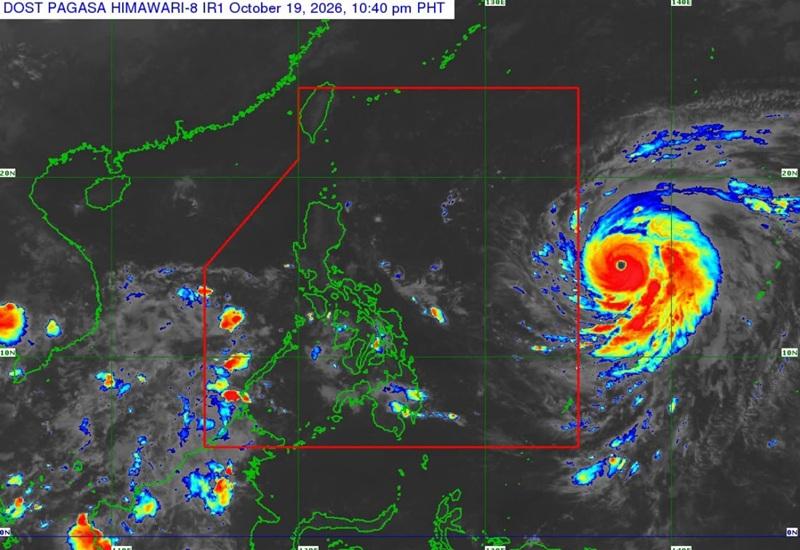
Super Typhoon Champi, which remains outside the Philippine Area of Responsibility (PAR), slightly intensifies and continues to move in the west northwest direction, according to the 11 p.m. Tropical Cyclone Bulletin posted by PAGASA.
As of 10 p.m., the center of the eye of Super Typhoon Champi was estimated at 1,680 kilometers east of Southeastern Luzon, packing maximum sustained winds of 195 kilometers near the center, gustiness of up to 240 km/h, and central pressure of 935 hPa.
Champi is moving west northwestward at the speed of 15 km/h with strong to typhoon-force winds extend outwards up to 720 km from the center.
General outlook
Super Typhoon Champi will continue moving west northwestward until it enters the PAR on Tuesday morning or early afternoon.
Inside the PAR, Champi will be given the domestic name Rosal, and will continue to move west northwestward until Wednesday October 21 before turning northward for the remaining forecast period.
Champi will exit the PAR region by Saturday, the 24th of October.
Meanwhile, Champi is forecast to maintain its strength as it enters the PAR and may further intensify while it moves over the Philippine Sea. A weakening trend is likely to begin by Thursday October 22, after it reaches peak intensity.
For land hazards
Wind Signals may be hoisted over the northern and eastern portions of Northern Luzon and portions of Bicol Region on Tuesday morning in anticipation of strong winds.
PAGASA said gusty conditions over most parts of Luzon and Visayas and portions of Mindanao are likely to begin by Wednesday and may bring heavy rains over extreme Northern Luzon.
For marine hazards
Moderate to rough seas may begin over the northern and eastern seaboards of Luzon and the eastern seaboards of Visayas and Mindanao by Tuesday.
Hazardous sea conditions (reaching very rough, high, or very high seas) may affect the northern and eastern seaboards of Luzon starting on Wednesday. — BAP, GMA News

