

 GMA Brandtalk
 Tracking
 Archives


PAGASA: 5 Luzon areas under Signal No. 1 as Super Typhoon Rosal intensifies
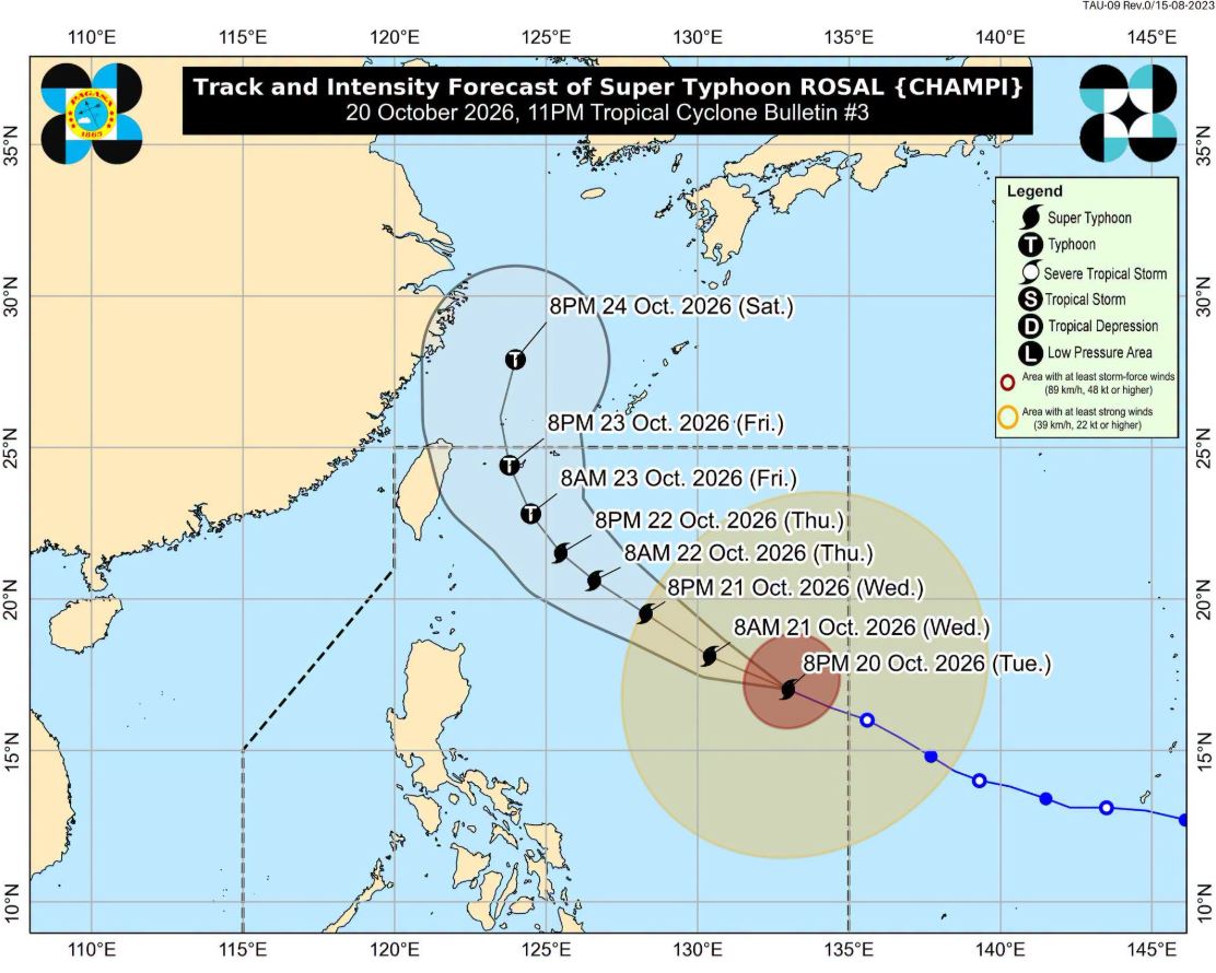
More areas in Luzon are now under Signal No. 1 as Super Typhoon Rosal intensifies further while moving west northwestward over the Philippine Sea, PAGASA said.
In its 11 p.m. tropical cyclone bulletin, Signal No. 1 is hoisted in the following areas:
- Batanes
- The eastern portion of Babuyan Islands (Babuyan Is., Camiguin Is., Didicas Is.)
- The eastern portion of mainland Cagayan (Santa Ana, Gonzaga, Lal-Lo, Santa Teresita, Camalaniugan, Aparri, Buguey, Gattaran, Baggao, Peñablanca)
- The northeastern portion of Isabela (Maconacon, Divilacan, Palanan, San Pablo, Cabagan, Santa Maria, Tumauini, Ilagan City)
- The northeastern portion of Catanduanes (Pandan, Bagamanoc, Panganiban, Viga, Gigmoto)
Under the tropical wind cyclone signal, winds of 39-61 kilometers per hour (km/h) may be expected in at least 36 hours, or intermittent rains may be expected within 36 hours, PAGASA said.
The center of the eye of Super Typhoon Rosal was estimated at 1,110 km east of Central Luzon or 1,150 km east of Northern Luzon.
It is moving west northwestward at 25 km/h with maximum sustained winds of 215 km/h near the center and gustiness of up to 265 km/h.
The highest wind signal that may be raised during the passage of Rosal is Wind Signal No. 2 or 3.
The Northeasterly Windflow and the periphery of Rosal will bring strong to gale-force gusts over the following areas (especially in coastal and upland areas exposed to winds):
October 20: Batanes, Ilocos Norte, Cagayan, Isabela, Polillo Islands, Camarines Norte, Camarines Sur, Catanduanes, Northern Samar, Eastern Samar, and Siargao-Bucas Grande Islands.
21 October: Ilocos Region, Cordillera Administrative Region, Cagayan Valley, Polillo Islands, Bicol Region, Romblon, Eastern Visayas, Iloilo, Guimaras, Negros Occidental, Siquijor, Bohol, Northern Mindanao, Caraga, Davao Region, Sarangani, and Zamboanga del Norte.
22 October: Most of Luzon and Visayas, Zamboanga del Norte, Northern Mindanao, Surigao del Norte, Dinagat Islands, Sarangani, Davao Occidental, and Davao Oriental.
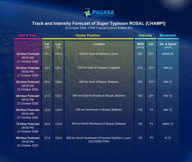
The super typhoon is forecast to move west northwestward until Wednesday (21 October) before moving generally northwestward until Friday (23 October) morning. On the forecast track, Rosal will be closest to extreme Northern Luzon between Thursday (22 October) and Friday.
Afterwards, this tropical cyclone will begin turning generally northward until it exits the Philippine Area of Responsibility by Friday evening or Saturday (24 October) early morning.
"Further intensification remains possible within the next 12 hours as Rosal moves over the Philippine Sea. This tropical cyclone will enter a weakening trend by Thursday and is forecast to weaken into a Typhoon by Friday morning," PAGASA said. —Lyjah Tiffany Bonzo/LDF, GMA News

