

 GMA Brandtalk
 Tracking
 Archives


Batanes, parts of Babuyan Is under Signal No. 2 as Rosal moves west northwestward
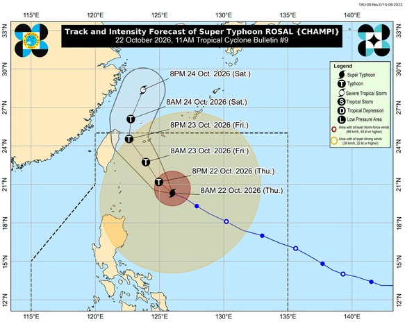
Batanes and the northeastern portion of Babuyan Islands remain under Tropical Cyclone Wind Signal No. 2 even as Super Typhoon Rosal further weakens and moves west northwestward at 20 kilometers per hour over the Philippine sea.
In its 11 a.m. bulletin, Thursday, state weather bureau PAGASA said under TCWS No. 1 are:
- the rest of Babuyan Islands,
- mainland Cagayan,
- the eastern portion of Isabela, including Maconacon, Divilacan, Palanan, Santa Maria, Cabagan, Delfin Albano, Santo Tomas, Tumauini, San Pablo, Ilagan City, San Mariano, Dinapigue,
- Ilocos Norte, and
- Apayao.
As of 10 a.m., the center of the eye of Super Typhoon Rosa was located 400 kilometers east of Basco, Batanes. it is packing maximum sustained winds of 185 km/h near the center, gustiness of up to 230 km/h, and central pressure of 925 hPa.
PAGASA said Rosal will continue moving generally northwestward until Thursday night.
It will begin to turn north northwestward by Friday morning before recurving north northeastward by Saturday, October 24.
On the forecast track, the tropical cyclone will be closest to extreme Northern Luzon between Thursday afternoon and Friday morning.
Rosal will exit the Philippine Area of Responsibility (PAR) by Friday evening or Saturday early morning.
PAGASA added that Rosal will continue to gradually weaken and may be downgraded into a typhoon within the day. By Saturday, the tropical cyclone will begin to rapidly weaken and may be downgraded into a severe tropical storm.
The public and disaster risk reduction and management offices concerned are advised to take all necessary measures to protect life and property.
Persons living in areas identified to be highly or very highly susceptible to these hazards are advised to follow evacuation and other instructions from local officials. —AOL, GMA News

