

Siony maintains course, likely to pass near Batanes within next 6 hours
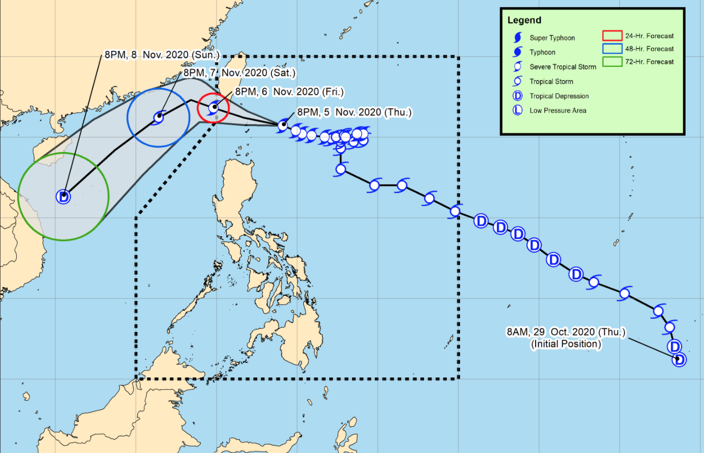
Severe Tropical Storm Siony (International name: Atsani) is likely to pass near or over Batanes within the next six hours as it continues to move in the west-northwest direction, according to the Severe Weather Bulletin issued by PAGASA late Thursday evening.
Siony may reach peak intensity and possibly intensify into a typhoon within the next 36 hours.
Meanwhile, Tropical Cyclone Wind Signal (TCWS) No. 2 remained raised over the following areas:
- Batanes
- Babuyan Island.
The following areas were, meanwhile placed under TCWS No. 1:
- the northern portion of mainland Cagayan (Santa Ana, Gonzaga, Lal-Lo, Allacapan, Santa Teresita, Buguey, Camalaniugan, Aparri, Ballesteros, Abulug, Pamplona, Sanchez-Mira, Claveria, Santa Praxedes)
- the northern portion of Apayao (Santa Marcela, Luna, Calanasan)
- the northern portion of Ilocos Norte (Adams, Pagudpud, Bangui, Dumalneg, Burgos, Vintar, Pasuquin, Bacarra)
According to PAGASA, damaging gale to storm-force winds are prevailing over areas under TCWS no. 2 while areas under TCWS no. 1 are experiencing strong breeze to near gale conditions.
The raising of TCWS no. 3 has not been ruled out, the weather agency said.
At 10 p.m. on Thursday, the center of Siony was estimated at 170 kilometers east of Basco, Batanes with maximum sustained winds of 100 kilometers per hour near the center and gustiness of up to 125 kph and moving west-northwestward at 20 kph.
PAGASA said Siony is forecast to exit the Philippine Area of Responsibility (PAR) on Friday afternoon or evening.
Hazards affecting land
Areas under TCWS No. 2 are currently experiencing damaging gale- to storm-force winds, while those under TCWS No. 1 are currently experiencing strong breeze to near gale conditions.
While it is more likely for Siony to remain a severe tropical storm during its passage over the Luzon Strait, the possibility of hoisting TCWS No. 3 remains as intensification into a typhoon is still not ruled out.
From Thursday night to Friday, the passage of Siony is expected to bring moderate to heavy rains over areas under TCWS No. 2 and light to moderate with, at times, heavy rains over areas under TCWS No. 1
“Flooding (including flash floods) and rain-induced landslides may occur during heavy or prolonged rainfall especially in areas identified in geohazard maps as highly or very highly susceptible to these hazards,” PAGASA said.
There is also a minimal to moderate risk of a storm surge of 1.0 to 2.0 meters over the coastal areas of Batanes and the Babuyan Islands within the next 24 hours.
Hazards affecting coastal waters
Meanwhile, rough to high seas are expected over the coastal waters of areas under TCWS no. 2 and TCWS no. 1 in the next 24 hours.
Due to rough to very rough seas, gale warnings have also been raised over locos Sur, La Union, Pangasinan, Western Coast Of Ilocos Norte, Isabela, Eastern Coast Of Cagayan, Aurora, and the Eastern Coast Of Quezon Including Polillo Island.
Sea travel is risky over these waters for all types of seacrafts in areas under TCWS and for small seacrafts in areas under gale warning.
Meanwhile, moderate to rough seas will prevail over the western seaboard of Central Luzon and the eastern seaboards of Southern Luzon, Visayas, and Mindanao.
“Mariners of small seacrafts are advised to take precautionary measures when venturing out to sea. Inexperienced mariners should avoid navigating in these conditions,” PAGASA said.
Other systems being monitored
The weather agency is also monitoring a low pressure area (LPA) outside the Philippine Area of Responsibility that was estimated at 1,600 km east of Visayas.
The LPA may enter PAR on Friday afternoon or evening and may reach Eastern Visayas by Saturday afternoon or evening and may intensity into a tropical depression within the next 48 to 72 hours. -- BAP, GMA News
