

Dante to bring light to heavy rain over Mindanao, Visayas, Bicol Region areas
Tropical Storm Dante (international name Choi-wan) would bring moderate to heavy rain over the Eastern Visayas, Dinagat Islands, Surigao del Norte, and Surigao del Sur, weather service PAGASA reported in a Monday evening bulletin.
Light to moderate with at times heavy rain could also be expected over Catanduanes, Albay, Sorsogon, Masbate, Cebu, Bohol, Camiguin, Misamis Oriental, Bukidnon, SOCCSKSARGEN, and the rest of the Caraga Region, and the Davao Region.
Given the inclement conditions, these areas may experience scattered flooding, including flash floods, and rain-induced landslides, especially in areas with high or very high susceptibility to these hazards.
Adjacent or nearby areas may also experience flooding due to surface runoffs or river channel swelling.
Meanwhile, Tropical Cyclone Wind Signal 1 was raised over:
- The eastern portion of Sorsogon (City of Sorsogon, Magallanes, Bulan, Juban, Irosin, Santa Magdalena, Matnog, Bulusan, Barcelona, Casiguran, Gubat, Prieto Diaz),
- the eastern portion of Albay (Rapu-Rapu),
- Northern Samar,
- Samar,
- Eastern Samar,
- Biliran,
- the eastern portion of Leyte (Leyte, Capoocan, Kananga, Jaro, Dagami, Burauen, Ormoc City, Javier, Mahaplag, Abuyog, Macarthur, Mayorga, La Paz, Dulag, Julita, Tolosa, Tabontabon, Tanauan, Palo, Tacloban City, Santa Fe, Pastrana, Alangalang, San Miguel, Barugo, Tunga, Carigara, Babatngon),
- the eastern portion of Southern Leyte (Sogod, Libagon, Saint Bernard, San Juan, Anahawan, Hinundayan, Silago, Hinunangan),
- the Dinagat Islands,
- Siargao Island, and
- the Bucas Grande Islands.
These areas would experience strong to near gale-force winds.
Also, PAGASA warned of rough to very rough sea conditions over the eastern seaboards of the Eastern Visayas and Caraga Regions. Sea travel over these areas was risky for small seacraft and mariners without the proper experience should immediately seek safe harbor.
Moderate to rough sea conditions could also be expected over the eastern seaboards of the Davao Region and the remaining seaboards of areas under Signal 1. Mariners of small seacraft are advised to take precautions when venturing out to sea. Inexperienced mariners should avoid navigating in these conditions.
At 10 p.m. Dante was 375 kilometers east of Surigao City, Surigao del Norte, with 75 kilometers per hour center winds that can gust up to 90 kph.
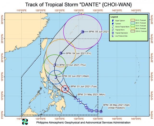
Dante was moving northwest at 20 kph and would continue moving generally northwestward until Wednesday.
The tropical storm would likely pass close to the eastern coast of the Bicol Region and Eastern Visayas between Tuesday evening and Wednesday evening.
However, given the westward shift in the forecast track, PAGASA warned that there was an increasing likelihood that Dante could make landfall over the Eastern Visayas or Bicol Region.
Dante was also projected to gradually intensify over the next 48 hours and reach severe tropical storm strength by Wednesday afternoon or evening.
It would then gradually weaken into a tropical storm by Thursday, and weaken further into a tropical depression by Friday. — DVM, GMA News
