

Jolina moves towards southern Samar, Signal No. 3 raised over 5 areas
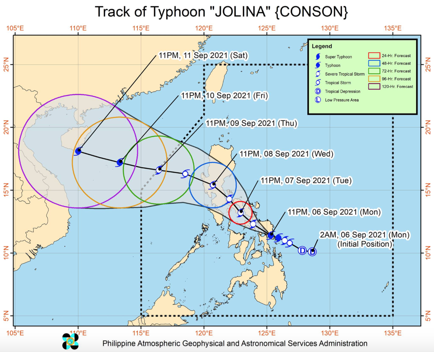
Typhoon Jolina continues to move in the west northwest direction over the southern portion of Samar province, according to the latest Sever Weather Bulletin posted by PAGASA.
As of 1 a.m., the center of the eye of Typhoon Jolina was estimated to be located in the vicinity of Santa Rita, Samar with maximum sustained winds of 120 kilometers per hour near the center, gustiness of up to 200 kph, and central pressure of 985 hPa.
Jolina is moving West Northwestward at 20 kph with strong winds or higher extend outwards up to 180 km from the center.
Tropical Cyclone Wind Signal (TCWS) No. 3 is hoisted over the following areas:
LUZON
- the southeastern portion of Masbate (Cataingan, Palanas, Pio V. Corpuz)
VISAYAS
- the extreme western portion of Northern Samar (San Isidro, San Antonio, Capul, San Vicente, Victoria, Allen)
- the eastern portion of Biliran (Kawayan, Culaba, Caibiran, Cabucgayan, Maripipi)
- the extreme northeastern portion of Leyte (Babatngon)
- the western and southern portions of Samar (Santa Rita, Basey, Marabut, Calbayog City, Santa Margarita, Gandara, Pagsanghan, Tarangnan, San Jorge, Jiabong, City of Catbalogan, Motiong, Hinabangan, Paranas, Calbiga, Pinabacdao, Villareal, Daram, Zumarraga, Talalora, San Sebastian, Almagro, Santo Niño, Tagapul-An)
- the southern portion of Eastern Samar (City of Borongan, Maydolong, Balangkayan, Llorente, Lawaan, Balangiga, General Macarthur, Hernani, Giporlos, Quinapondan, Salcedo, Mercedes, Guiuan)
TCWS No. 2 has been raised over the following areas:
LUZON
- Albay
- Sorsogon
- the rest of Masbate including Ticao and Burias Islands
- the western and southern portions of Camarines Sur (Del Gallego, Lupi, Ragay, Libmanan, Sipocot, Cabusao, Pasacao, Pamplona, Gainza, Camaligan, Canaman, Magarao, Bombon, Naga City, Pili, Ocampo, Iriga City, Sagñay, Buhi, Milaor, San Fernando, Minalabac, Bula, Nabua, Baao, Balatan, Bato)
- the southeastern portion of Quezon (Tagkawayan, Guinayangan, Buenavista, Mulanay, San Narciso, San Francisco, San Andres, Catanauan)
- the eastern portion of Romblon (San Fernando, Magdiwang, Cajidiocan, Romblon)
VISAYAS
- the rest of Biliran
- the rest of Northern Samar
- the rest of Samar
- the rest of Eastern Samar
- the northern portion of Leyte (Calubian, San Isidro, Tabango, Leyte, Villaba, Matag-Ob, Ormoc City, Kananga, Capoocan, Carigara, Jaro, Dagami, Julita, Tabontabon, Tolosa, Tanauan, Palo, Pastrana, Santa Fe, Tacloban City, Barugo, San Miguel, Alangalang, Dulag)
The areas under TCWS No. 1 are the following:
LUZON
- Catanduanes
- the rest of Camarines Sur, Camarines Norte, the central portion of Quezon (Sariaya, Lucban, Sampaloc, Mauban, Perez, Alabat, Quezon, Calauag, Lopez, Macalelon, General Luna, Gumaca, Pitogo, Plaridel, Atimonan, Unisan, Agdangan, Padre Burgos, Pagbilao, City of Tayabas, Lucena City)
- Marinduque
- the rest of Romblon
VISAYAS
- the rest of Leyte
- Southern Leyte
- the northern portion of Cebu (Carmen, Tuburan, Catmon, Sogod, Tabuelan, Borbon, Tabogon, San Remigio, City of Bogo, Medellin, Daanbantayan) including Camotes and Bantayan Islands
- the northeastern portion of Iloilo (Concepcion, Sara, San Dionisio, Batad, Estancia, Carles, Balasan)
- the extreme northern portion of Capiz (Pilar, Panay, Roxas City)
MINDANAO
- Dinagat Islands
The Tropical Cyclone Wind Signal No. 1 earlier hoisted over Siargao and Bucas Grande Islands has been lifted.
HAZARDS AFFECTING LAND AREAS
In the next 24 hours, the typhoon may bring heavy to intense with at times torrential rains over Samar, Eastern Samar, Northern Samar, Sorsogon, Leyte, Biliran, and Masbate.
Moderate to heavy with at times intense rains are also likely over the southern portion of Quezon, Romblon, Marinduque and the rest of Eastern Visayas and Bicol Region.
Destructive typhoon-force winds are likely to occur within any of the areas where TCWS No. 3 is in effect and will experience generally moderate to heavy damage to structures and vegetation.
Damaging gale-force to storm-force winds are likely to occur within any of the areas under TCWS No. 2 is in effect wherein there will generally light to moderate damage to structures and vegetation.
In areas under TCWS No. 1, residents are expected to experience strong winds with occasional gusts that may result to up to very light damage to structures and vegetation.
There is a moderate to high risk of life-threatening coastal inundation due to storm surge of up to 1.0 m over the coastal localities of Eastern Samar. In addition, coastal areas of localities under TCWS No. 2 and No. 3 may experience coastal flooding which may pose threat to life and property due to hazardous surf conditions.
HAZARDS AFFECTING COASTAL WATERS
Jolina will bring rough to very rough seas over the seaboards of areas under TCWS No. 2 and No. 3 where sea travel is risky for all types of seacrafts over these waters. Mariners without the proper experience should immediately seek safe harbor.
Areas under TCWS No. 1 and the and the eastern seaboards of Mindanao will experience moderate to rough seas . Mariners of small seacrafts are advised to take precautionary measures when venturing out to sea. Inexperienced mariners should avoid navigating in these conditions.
TRACK AND INTENSITY OUTLOOK
Jolina will move generally northwestward across the Eastern Visayas-Southern Luzon area in the next 36 hours and will cross Samar and Bicol Region on Tuesday or Wednesday morning before emerging over Lamon Bay by noontime also on Wednesday.
The typhoon is expected to make another landfall over northern Quezon as it traverses through up to the West Philippine Sea on Thursday morning.
Jolina is also forecast to weaken into a severe tropical storm within 12 hours but it is expected to re-intensify and may reach typhoon category by Friday as it moves over the West Philippine Sea. -- BAP, GMA News
