

Chedeng now a storm, spotted east of Luzon
Chedeng has intensified into a Tropical Storm and continues to move in the north northwest direction, according to the Tropical Cyclone Bulletin posted late Tuesday evening by PAGASA.
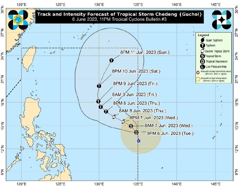
The center of Tropical Storm Chedeng was estimated at 1,145 kilometers east of Southeastern Luzon packing maximum sustained winds of 65 kilometers per hour near the center, gustiness of up to 80 km/h, and central pressure of 1000 hPa.
Chedeng is moving north northwestward at a speed of 10 km/h with strong to gale-force winds extend outwards up to 340 km from the center.
There are no Wind Signals hoisted at this time.
Hazards affecting land areas
Chedeng is unlikely to directly bring heavy rainfall over any portion of the country in the next 3 to 5 days.
PAGASA advises the public to continue monitoring for updates regarding the possible enhancement of the Southwest Monsoon.
Severe Winds
"The hoisting of Wind Signals in anticipation of tropical cyclone severe winds is unlikely at this time," PAGASA said.
"The Southwest Monsoon may be strengthened as a result of Chedeng, but under the current forecast scenario, the likelihood of intermittent wind gusts resulting from the monsoon winds may still change because the monsoon enhancement depends on the forecast movement and intensity of Chedeng and its interaction with the other weather systems around it.
Hazards affecting coastal waters
At this time, the weather bureau reported, Tropical Storm Chedeng remains unlikely to cause rough sea condition over the coastal waters of the country in the next 24 hours.
Track and Intensity outlook
"As Chedeng continues to consolidate while intensifying, it is forecast to move generally northwestward or west northwestward tonight through mid-Friday, before turning more northward or north northeastward for the rest of Friday through weekend," PAGASA said, adding that Chedeng will remain far from the Philippine landmass.
Chedeng is forecast to intensify in the next 3 to 4 days and may be upgraded to severe tropical storm category on Wednesday and into a typhoon on Thursday. However, rapid intensification is not ruled out.
PAGASA adds that peak intensity may be reached by Friday or Saturday. -- BAP, GMA Integrated News
