

LPA, Habagat to bring rains over parts of PH
Several parts of the country may experience rains brought by the low pressure area (LPA) and the Southwest Monsoon (Habagat) in the next three days, the state weather bureau PAGASA said Wednesday.
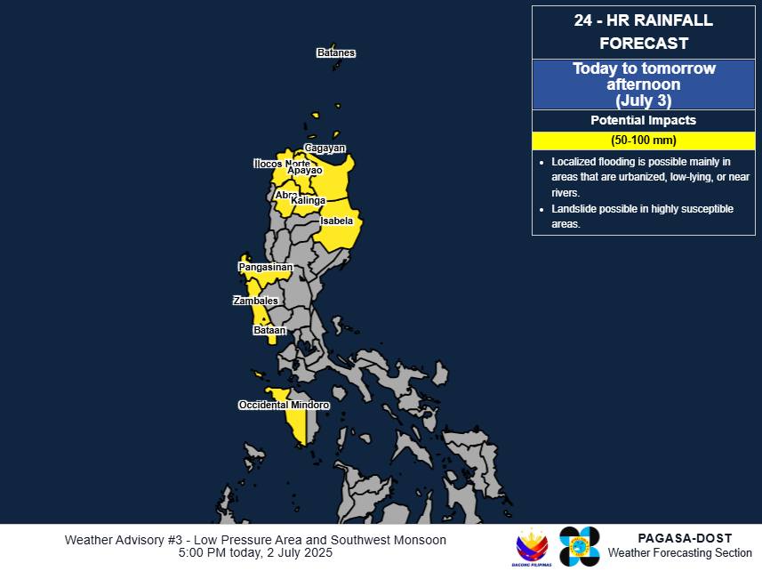
Here is PAGASA’s heavy rainfall outlook due to the LPA:
Wednesday to Thursday afternoon (July 3)
(50-100 mm):
Batanes, Cagayan, Isabela, Apayao, Kalinga, Abra, Ilocos Norte, Pangasinan, Zambales, Bataan, and Occidental Mindoro
Thursday afternoon to Friday afternoon (July 4)
(100-200 mm):
Batanes, Cagayan, Zambales, Bataan, and Occidental Mindoro
(50-100 mm):
Apayao, Kalinga, Ilocos Norte, Ilocos Sur, Abra, Ifugao, Mountain Province, Metro Manila, La Union, Pangasinan, Benguet, Tarlac, Pampanga, Bulacan, Rizal, Laguna, Cavite, and Batangas
Friday afternoon to Saturday afternoon (July 5)
(50-100 mm):
Batanes, Cagayan, Apayao, Ilocos Norte, Ilocos Sur, La Union, Pangasinan, Abra, Benguet, Zambales, Bataan, and Occidental Mindoro
Here’s the rainfall outlook due to Habagat:
Wednesday to Thursday afternoon (July 3)
(50-100 mm):
Pangasinan, Zambales, Bataan, and Occidental Mindoro
Thursday afternoon to Friday afternoon (July 5)
(50-100 mm):
Metro Manila, Ilocos Sur, La Union, Pangasinan, Benguet, Tarlac, Pampanga, Bulacan, Rizal, Laguna, Cavite, and Batangas
(100-200 mm):
Zambales, Bataan, and Occidental Mindoro
Friday afternoon to Saturday afternoon (July 5)
(50-100 mm):
Ilocos Sur, La Union, Pangasinan, Abra, Benguet, Zambales, Bataan, and Occidental Mindoro
“Forecast rainfall may be higher in mountainous and elevated areas. Moreover, impacts in some areas may be worsened by significant antecedent rainfall,” said PAGASA.
PAGASA is monitoring the LPA that was located 155 kilometers east of Tuguegarao City, Cagayan as of 3 p.m. Wednesday. The state weather bureau said that it has a “high” chance of developing into a tropical depression within 24 hours. — Vince Angelo Ferreras/VBL, GMA Integrated News
