

Signal No. 2 up over 8 areas as Crising threatens Cagayan, Babuyan Islands
Tropical Cyclone Wind Signal (TCWS) No. 2 is raised over eight areas in Luzon as Tropical Storm Crising is seen to make landfall over Cagayan or Babuyan Islands on Friday afternoon or evening, state weather bureau PAGASA said.
In its 8 a.m. bulletin, PAGASA said the following areas are under TCWS No. 2:
- Batanes
- Cagayan including Babuyan Islands
- The northern and eastern portions of Isabela (Palanan, Ilagan City, Divilacan, Delfin Albano, Quezon, Tumauini, Maconacon, Santa Maria, Cabagan, San Pablo, Santo Tomas, San Mariano, Dinapigue)
- Apayao
- The northern portion of Kalinga (City of Tabuk, Balbalan, Pinukpuk, Rizal)
- The northern portion of Abra (Malibcong, Lacub, Lagangilang, Licuan-Baay, Danglas, Lagayan, San Juan, Tineg, La Paz, Dolores)
- Ilocos Norte
- The northern portion of Ilocos Sur (Cabugao, Sinait)
TCWS No. 1 is hoisted in the following areas:
- The rest of Isabela
- Quirino
- Nueva Vizcaya
- The rest of Kalinga
- Mountain Province
- Ifugao
- The rest of Abra
- Benguet
- The rest of Ilocos Sur
- La Union
- The northern portion of Pangasinan (San Nicolas, Natividad, San Quintin, San Manuel, Tayug, Sison, San Fabian, Pozorrubio, Laoac, Binalonan, San Jacinto, Manaoag, Mangaldan, Dagupan City, Binmaley, Lingayen, Labrador, Sual, City of Alaminos, Bolinao, Anda, Bani, Agno, Burgos, Mabini, Dasol, Calasiao, Santa Barbara, Mapandan, Bugallon)
- The northern portion of Aurora (Dilasag, Casiguran, Dinalungan, Dipaculao, Baler, Maria Aurora)
- The northeastern portion of Nueva Ecija (Carranglan, Pantabangan)
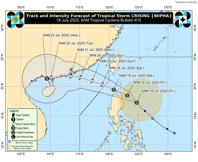
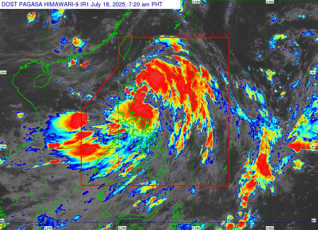
Crising was last located 250 kilometers east of Tuguegarao City, Cagayan.
The tropical storm was packing maximum sustained winds of 65 km per hour near the center, gustiness of up to 80 km/h, and central pressure of 996 hPa.
Its strong to gale-force winds extend outwards up to 500 km from the center.
Crising is moving northwestward at 15 km/h.
“Crising will move generally northwestward within the next 12 hours. On the forecast track, a landfall scenario over mainland Cagayan or Babuyan Islands this afternoon or evening is possible,” PAGASA said.
“Afterwards, it will move west northwestward traversing over Extreme Northern Luzon until it exits the Philippine Area of Responsibility by tomorrow afternoon," it added.
Cruising is expected to further intensify until it reaches the severe tropical storm category by Saturday morning or afternoon, according to PAGASA. —VAL, GMA Integrated News
