

Crising keeps strength, nears Sta. Ana, Cagayan
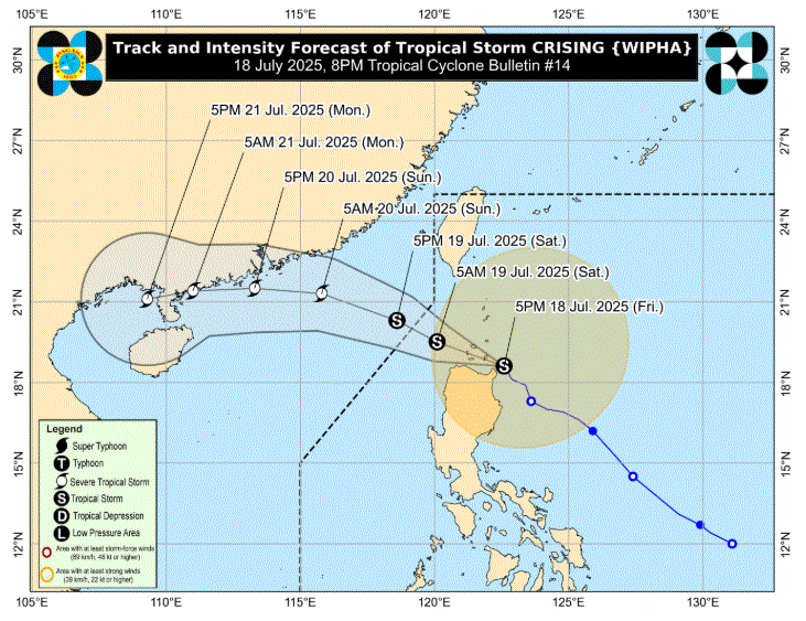
Tropical Storm Crising maintained its strength as it nears Sta. Ana, Cagayan, according to PAGASA's tropical cyclone bulletin issued at 8 p.m.
It will move west northwestward within the next 12 hours, and may make landfall or pass close to Babuyan Islands Friday evening. It will continue to move west northwestward until it exits the Philippine Area of Responsibility by July 19, Saturday.
The center of Bising was estimated at 100 kilometers Northeast of Aparri, Cagayan. It has a maximum sustained winds of 75 kilometers per hour near the center and gustiness of up to 90 kph.
Tropical Cyclone Wind Signal No. 2 is hoisted in the following Luzon provinces:
- Batanes
- Cagayan including Babuyan Islands
- Isabela
- Apayao
- Kalinga
- the northern and central portions of Abra (Manabo, Pidigan, San Juan, Tayum, Langiden, Boliney, Sallapadan, Bucloc, Lagangilang, Danglas, La Paz, Licuan-Baay, Tineg, Malibcong, Peñarrubia, San Isidro, Daguioman, San Quintin, Dolores, Lagayan, Bangued, Bucay, Lacub)
- the eastern portion of Mountain Province (Natonin, Paracelis)
- the eastern portion of Ifugao (Aguinaldo, Alfonso Lista)
- Ilocos Norte
- the northern portion of Ilocos Sur (Cabugao, Sinait, Magsingal, San Juan, San Ildefonso, Santo Domingo, Bantay, San Vicente, Santa Catalina, Caoayan, City of Vigan, Santa)
The following areas are under Signal No. 1:
- Quirino
- Nueva Vizcaya
- the rest of Mountain Province
- the rest of Ifugao
- the rest of Abra
- Benguet
- the rest of Ilocos Sur
- La Union
- the northern portion of Pangasinan (San Nicolas, Natividad, San Quintin, San Manuel, Tayug, Sison, San Fabian, Pozorrubio, Laoac, Binalonan, San Jacinto, Manaoag, Mangaldan, Dagupan City, Binmaley, Lingayen, Labrador, Sual, City of Alaminos, Bolinao, Anda, Bani, Agno, Burgos, Mabini, Dasol, Calasiao, Santa Barbara, Mapandan, Bugallon)
- the northern portion of Aurora (Dilasag, Casiguran, Dinalungan, Dipaculao, Baler, Maria Aurora)
- the northeastern portion of Nueva Ecija (Carranglan, Pantabangan)
"The wind signals warn the public of the general wind threat over an area due to the tropical cyclone. Local winds may be slightly stronger/enhanced in coastal and upland/mountainous areas exposed to winds. Winds are less strong in areas sheltered from the prevailing wind direction," PAGASA said.
It added that minor to moderate impacts from gale-force winds are possible within any of the localities where Wind Signal No. 2 is hoisted. Minimal to minor impacts from strong winds are possible within any of the areas under Wind Signal No. 1.
Meanwhile, the Southwest Monsoon will bring strong to gale-force gusts over the following areas:
Friday: Zambales, Bataan, Cavite, Batangas, Quezon, Bicol Region, MIMAROPA, Visayas, Zamboanga del Norte, Camiguin, Misamis Oriental, Misamis Occidental, Lanao del Norte, Surigao del Norte, Dinagat Islands, Davao Occidental, Davao Oriental, and Sarangani.
Saturday: Metro Manila, Pangasinan, Central Luzon, CALABARZON, MIMAROPA, Bicol Region, Visayas, Zamboanga Peninsula, Basilan, Sulu, Tawi-Tawi, Misamis Occidental, Lanao del Norte, Camiguin, Surigao del Norte, Dinagat Islands, Davao Occidental, and Davao Oriental. —LDF, GMA Integrated News
