

Habagat to bring strong to gale-force gusts as Emong exits PAR
The enhanced Southwest Monsoon (Habagat) is expected to bring strong to gale-force gusts over parts of the country as Tropical Depression Emong exited the Philippine Area of Responsibility (PAR) on Saturday morning, state weather bureau PAGASA said.
No Tropical Cyclone Wind Signal was issued in its 11 a.m. advisory.
However, strong to gale-force gusts may be expected over the following areas (especially in coastal and upland areas exposed to winds): Batanes, Babuyan Islands, Ilocos Region, Cordillera Administrative Region, Nueva Vizcaya, Quirino, Central Luzon, Metro Manila, CALABARZON, MIMAROPA, Bicol Region, Northern Samar, Western Visayas, Negros Occidental, and Davao Oriental.
Rough seas are also expected over the following coastal waters, where mariners of small seacrafts, including all types of motorbancas, are advised not to venture out to sea under these conditions, especially if inexperienced or operating ill-equipped vessels:
- Up to 4.0 m: The seaboards of Batanes and Babuyan Islands; the northern seaboard of Ilocos Norte
- Up to 3.0 m: The seaboards of mainland Cagayan and Isabela; the western seaboards of Ilocos Norte, Ilocos Sur, Pangasinan, and Zambales
Meanwhile, up to moderate seas will be over the following coastal waters, where mariners of motorbancas and similarly-sized vessels are advised to take precautionary measures while venturing out to sea and, if possible, avoid navigation under these conditions:
- Up to 2.5 m: The western seaboards of Bataan, Lubang Islands, Occidental Mindoro, Palawan including Calamian Islands, and Kalayaan Islands; the northeastern seaboard of Aurora
- Up to 2.0 m: The remaining seaboards of Bataan, Lubang Islands, Occidental Mindoro, Palawan, and Aurora; the northern and eastern seaboards of Polillo Islands, Camarines Norte, Catanduanes, and Northern Samar; the eastern seaboards of Sorsogon, Surigao del Sur, and Davao Oriental; the western seaboards of Batangas, Antique, and Guimaras; the southern seaboards of Oriental Mindoro, Marinduque and Quezon; the southwestern seaboard of Iloilo; the northern and western seaboards of Ticao Island and Romblon; the seaboards of Camarines Sur.
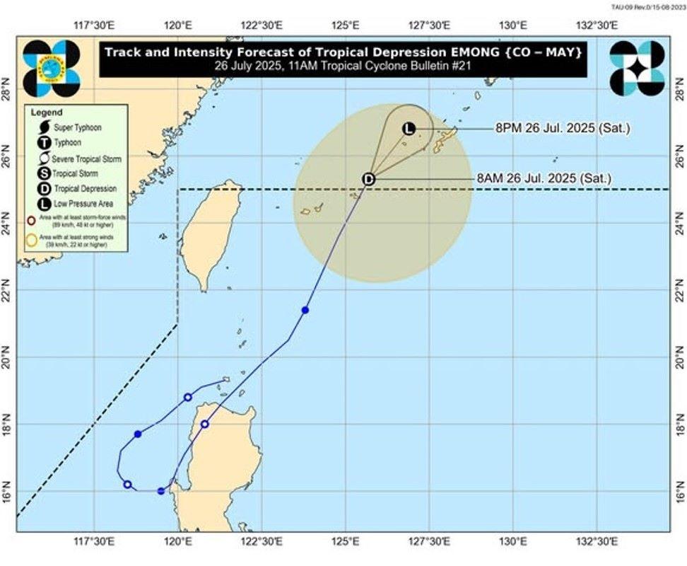
“EMONG is forecast to weaken into a remnant low today while over the East China Sea,” PAGASA said in its track and intensity outlook of the tropical cyclone.
The center of Emong was estimated based on all available data at 695 km northeast of Itbayat, Batanes (25.7 °N, 126.0 °E), which is outside PAR.
Moving north northeastward at 35 km/h, it has maximum sustained winds of 55 km/h near the center and gustiness of up to 70 km/h. —KG, GMA Integrated News
