

Isang crosses Quirino; 16 Luzon provinces remain under Signal No. 1
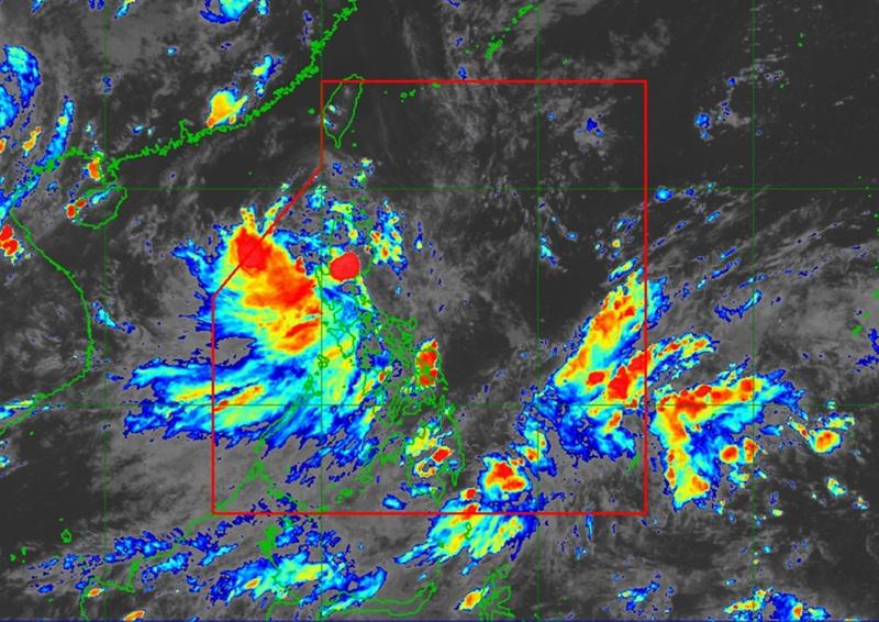
Sixteen provinces in Luzon remain under Tropical Cyclone Wind Signal (TCWS) No. 1 as Tropical Depression “Isang” slowed down slightly while crossing Quirino province on Friday afternoon, August 22, according to the PAGASA.
Areas under TCWS No. 1:
- Cagayan
- Isabela
- Quirino
- Nueva Vizcaya
- Apayao
- Kalinga
- Abra
- Mountain Province
- Ifugao
- Benguet
- Ilocos Norte
- Ilocos Sur
- La Union
- Pangasinan
- Aurora
- Northern Nueva Ecija (Lupao, Carranglan, Pantabangan, San Jose City)
The state weather bureau said these areas may experience minimal to minor wind impacts, with stronger gusts possible in coastal and upland communities.
As of 5:00 p.m., Isang was moving west-northwest at 15 km/h, packing maximum sustained winds of 55 km/h near the center and gusts of up to 70 km/h.
The system is forecast to emerge over the West Philippine Sea Friday night, where it may intensify into a tropical storm as early as Saturday.
PAGASA said Isang could further strengthen into a severe tropical storm as it approaches the waters south of Hainan, China.
The tropical depression is expected to exit the Philippine Area of Responsibility (PAR) by Saturday morning or afternoon, August 23.
Heavy rainfall outlook
PAGASA warned that heavy to intense rains (100–200 mm) may be experienced in Zambales and Bataan until Saturday, while moderate to heavy rains (50–100 mm) could affect La Union, Pangasinan, Benguet, Pampanga, Quirino, Nueva Vizcaya, Aurora, Ifugao, Cagayan, Isabela, Nueva Ecija, Tarlac, and Quezon.
The southwest monsoon, enhanced by Isang, will also bring heavy to intense rains over Occidental Mindoro and moderate to heavy rainfall across Metro Manila, Bulacan, Rizal, Laguna, Cavite, Batangas, Marinduque, Romblon, Oriental Mindoro, Palawan, Antique, and Aklan. From Saturday afternoon to Sunday, rains are expected to persist over Palawan and Occidental Mindoro.
PAGASA warned that rainfall amounts could be higher in mountainous and elevated areas, and flooding and landslides remain possible especially in areas already saturated by previous rains.
Winds and coastal hazards
Aside from rains, Isang will also bring strong to gale-force gusts over parts of Zambales, Bataan, Metro Manila, CALABARZON, MIMAROPA, Camarines Norte, Camarines Sur, Catanduanes, Burias Island, Western Visayas, Negros Island Region, Central Visayas, Dinagat Islands, Southern Leyte, Surigao del Norte, and Camiguin.
By Saturday, gusty conditions are expected in Batanes, Cagayan, Ilocos Region, Cordillera Administrative Region, Zambales, Bataan, Tarlac, Pampanga, Bulacan, Metro Manila, Cavite, Rizal, Palawan, Occidental Mindoro, Romblon, and Camarines Sur.
No gale warning has been raised so far, but rough seas of up to 3.0 meters may affect the seaboards of Batanes and Cagayan, while moderate seas of up to 2.5 meters are expected in the waters off Isabela, Ilocos Norte, and Ilocos Sur. PAGASA advised small vessels and motorbancas to avoid sailing in these areas.
DisasterPublic advisory management offices and local government units have been advised to take precautionary measures against possible flooding and landslides. PAGASA regional services divisions are also expected to issue localized rainfall and thunderstorm advisories as necessary.
The next severe weather bulletin will be issued at 8:00 p.m. Friday. — BAP, GMA Integrated News
