

Storm Signal 5 over parts of Babuyan Islands as Nando moves closer
Storm Signal No. 5 remained hoisted over the northern portion of Babuyan Islands Monday morning as Super Typhoon Nando maintained its strength and moves closer, state weather bureau PAGASA said.
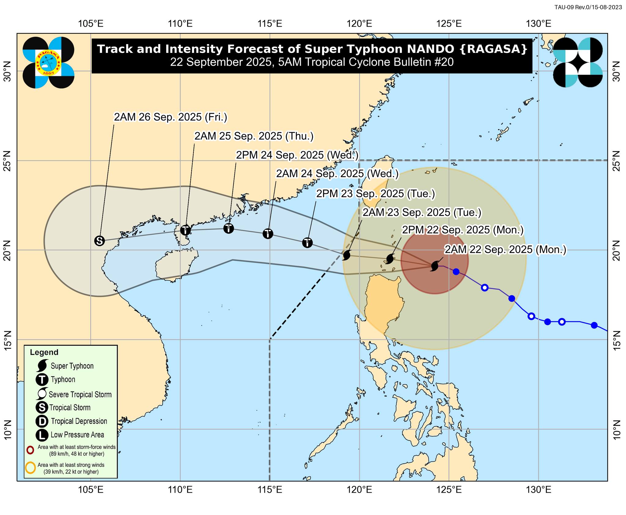
In its 5 a.m. tropical cyclone bulletin, PAGASA said the center of the eye of Nando (international name: Ragasa) was estimated at 245 km east of Calayan, Cagayan. It added that strong to typhoon-force winds extend outwards up to 600 km from the center.
Nando is packing a maximum sustained winds of 205 km/h near the center, gustiness of up to 250 km/h, and central pressure of 915 hPa. It is moving west northwestward at 20 km/h.
PAGASA said the following tropical cyclone wind signals have been assigned:
Signal No. 5
- The northern portion of Babuyan Islands (Babuyan Isl., Didicas Isl., Panuitan Isl., Calayan Isl.)
Signal No. 4
- The southeastern portion of Batanes (Basco, Mahatao, Ivana, Uyugan, Sabtang), the rest of Babuyan Islands, and the northeastern portion of mainland Cagayan (Santa Ana)
Signal No. 3
- The rest of Batanes,
- the northern and central portions of mainland Cagayan (Gonzaga, Lal-Lo, Gattaran, Baggao, Alcala, Santo Niño, Lasam, Allacapan, Camalaniugan, Buguey, Santa Teresita, Aparri, Ballesteros, Abulug, Pamplona, Sanchez-Mira, Claveria, Santa Praxedes, Rizal, Amulung, Piat),
- the northern and central portions of Apayao (Flora, Santa Marcela, Pudtol, Luna, Calanasan, Kabugao), and
- the northern and central portions of Ilocos Norte (Carasi, Piddig, Vintar, Bacarra, Pasuquin, Burgos, Bangui, Dumalneg, Pagudpud, Adams, Nueva Era, Solsona, Dingras, Sarrat, Laoag City, San Nicolas, Currimao, Paoay, City of Batac, Marcos, Banna)
Signal No. 2
- The rest of Cagayan, Isabela,
- the rest of Apayao,
- Abra,
- Kalinga,
- Mountain Province,
- Ifugao,
- the northern portion of Benguet (Mankayan, Buguias, Bakun, Kibungan),
- the northeastern portion of Nueva Vizcaya (Diadi),
- the rest of Ilocos Norte, Ilocos Sur, and
- the northern portion of La Union (Sudipen, Bangar, Luna, Balaoan, Santol)
Signal No. 1
- Quirino,
- the rest of Nueva Vizcaya,
- the rest of Benguet,
- the rest of La Union,
- Pangasinan,
- Aurora,
- Nueva Ecija,
- Bulacan,
- Tarlac,
- Pampanga,
- Zambales, and
- the northern portion of Quezon (General Nakar) including Polillo Islands
PAGASA said Nando will begin to turn westward on Monday towards Babuyan Islands.
It added the center of Nando may pass close or may make landfall over Babuyan Islands between noon and early afternoon Monday. It may exit the Philippine area of responsibility by September 23, Tuesday morning.
It further said Nando may maintain its strength or further intensify before it approaches the Babuyan Islands.
The state weather bureau said the southwest monsoon (Habagat) and the trough of Nando will bring strong to gale-force gusts over the following areas, especially in coastal and upland areas exposed to winds:
- Metro Manila,
- Central Luzon (areas not under wind signal),
- CALABARZON,
- Bicol Region,
- MIMAROPA,
- Visayas,
- Northern Mindanao,
- Caraga,
- Zamboanga Peninsula,
- BARMM,
- SOCCSKSARGEN, and
- Davao Region.
PAGASA warned of "up to very rough, high, or very high seas" over the following coastal waters. It said sea travel is risky for all types or tonnage of vessels, adding mariners must remain in port or, if underway, seek shelter or safe harbor as soon as possible until winds and waves subside.
- Up to 14.0 m: The seaboards of Batanes and Babuyan Islands.
- Up to 12.0 m: The northern seaboard of Ilocos Norte
- Up to 10.0 m: The northern seaboard of mainland Cagayan; the remaining seaboards of Ilocos Norte.
- Up to 8.0 m: The northwestern seaboard of Ilocos Sur; the remaining seaboard of mainland Cagayan
- Up to 5.5 m: The remaining seaboard of Ilocos Sur; the seaboard of Isabela, and the western seaboard of Pangasinan
- Up to 5.0 m: The northeastern seaboard of Aurora; the northwestern seaboard of La Union
Meanwhile, mariners of small seacrafts, including all types of motorbancas, are advised not to venture out to sea, especially if inexperienced of operating ill-equipped vessels due to "up to rough seas" over the following coastal waters:
- Up to 4.0 m: The seaboard of Zambales; the remaining seaboards of Aurora; the northern and eastern seaboard of Polillo Islands
- Up to 3.0 m: The remaining seaboards of La Union and Pangasinan; the seaboards of Bataan, Lubang Island, and Camarines Norte; the northern seaboard of Camarines Sur; the northern and eastern seaboards of Catanduanes; the northwestern seaboard of Occidental Mindoro; the western seaboard of Calamian Islands
On the other hand, up to moderate seas will be experienced over the following coastal waters:
- Up to 2.5 m: The eastern seaboards of Albay and Sorsogon; the remaining seaboard of Camarines Sur; the northern and eastern seaboards of Northern Samar and Eastern Samar; the seaboards of Kalayaan Islands and Palawan; the remaining seaboards of Calamian Islands and Occidental Mindoro; the southern seaboard of Quezon and Marinduque; the northern seaboard of Romblon; the northwestern seaboard of Burias Island.
Mariners of motorbancas and similarly-sized vessels are advised to take precautionary measures while venturing out to sea and, if possible, avoid navigation under these conditions.
PAGASA also warned that there is a high risk of life-threatening storm surge with peak heights exceeding 3 meters within the next 24 hours over the low-lying or exposed coastal localities of Batanes, Cagayan including Babuyan Islands, Ilocos Norte, and Ilocos Sur.—AOL, GMA Integrated News
