

More areas under Signal No. 1 as Paolo slows down
Signal No. 1 was hoisted in more areas as Tropical Depression Paolo slightly slowed down and moved westward over the Philippine Sea, PAGASA said late Wednesday evening.
Based on the state weather bureau’s 11 p.m. bulletin, Signal No. 1 was raised in the following areas:
- the eastern and central portions Isabela (Alicia, San Mateo, Aurora, San Mariano, Ramon, Naguilian, Dinapigue, Roxas, San Guillermo, Luna, City of Cauayan, Echague, Ilagan City, Angadanan, Benito Soliven, City of Santiago, Reina Mercedes, San Agustin, San Manuel, Palanan, Cabatuan, Quirino, Gamu, San Isidro, Cordon, Jones, Burgos, Maconacon, Divilacan, Tumauini)
- Quirino
- the northern and central portions of Aurora (Dilasag, Casiguran, Dinalungan, Dipaculao, Baler, Maria Aurora, San Luis)
- the northern portion of Catanduanes (Pandan, Bagamanoc, Panganiban, Viga)
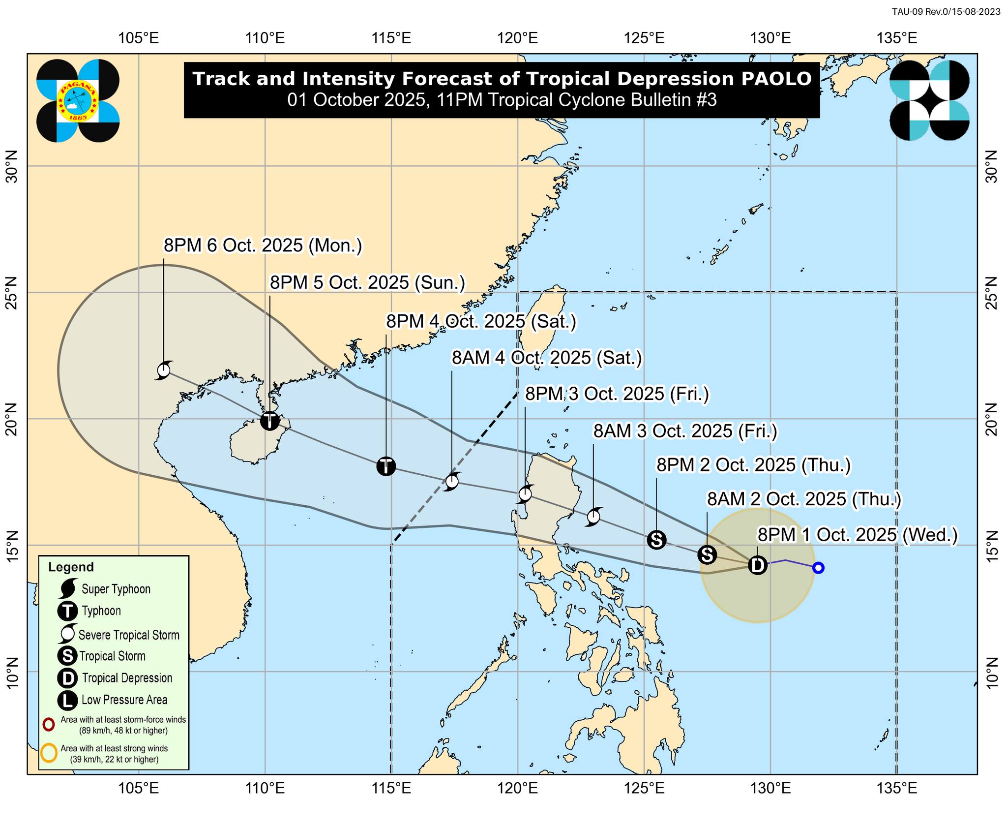
At 10 p.m., Paolo was located 565 km east of Virac, Catanduanes or 695 km east of Daet, Camarines Norte.
It was carrying maximum sustained winds of 55 km/h near the center and gusts of up to 70 km/h, and was moving westward at 20 km/h.
State meteorologists indicate that Signal No. 3 will likely be raised during Paolo’s passage, with the possibility of Signal No. 4 if the storm reaches typhoon category.
Within 48 hours, there is a moderate risk of life-threatening storm surge with peak heights reaching 1.0 to 2.0 m over the low-lying or exposed coastal localities of Cagayan, Isabela, Aurora, and Quezon, PAGASA said.
A gale warning may also be raised over the seaboards of Northern and Central Luzon as early as Thursday afternoon in anticipation of rough to very rough sea conditions caused by the passage of the storm.
The state weather bureau said Paolo could make landfall over Isabela or northern Aurora on Friday morning or afternoon.
“It must be emphasized that heavy rainfall, severe winds, and storm surge may still be experienced in localities outside the landfall point and the forecast confidence cone,” PAGASA said.
It added that a southward shift of track is possible depending on the strength of the high pressure area to the north of Paolo.
“The track may still shift within the limit of the forecast confidence cone,” PAGASA said.
Paolo is expected to exit the Philippine Area of Responsibility by Saturday morning.
It will then continue to intensify over the Philippine Sea and may reach severe tropical storm category by early Friday morning.
“Further intensification into a typhoon prior to landfall is not ruled out. Re-intensification is highly likely once PAOLO emerges over the West Philippine Sea,” PAGASA said. —Mariel Celine Serquiña/VBL, GMA Integrated News
