

12 areas under Signal No. 2 as Paolo moves west
More areas have been placed under Signal No. 2 as Tropical Storm Paolo continues to move west northwestward over the Philippine Sea, the state weather bureau PAGASA said on Thursday evening.
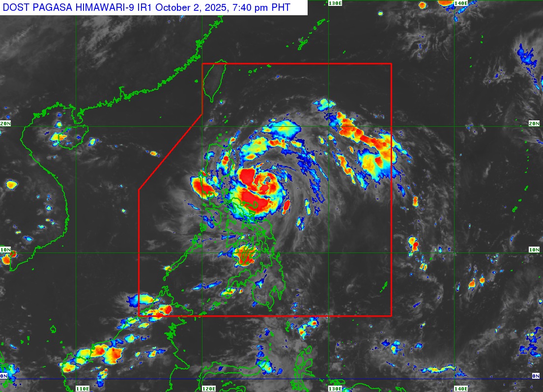
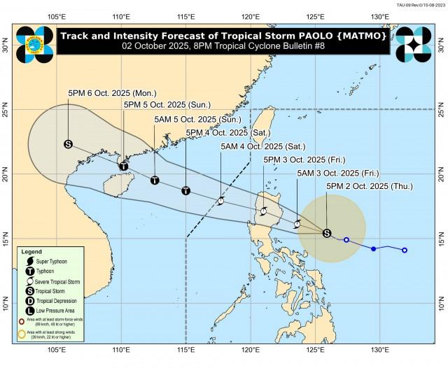
According to the 8 p.m. weather bulletin, the center of the tropical storm was monitored 370 kilometers east of Baler, Aurora as of 7 p.m. It has maximum sustained winds of 85 km/h near the center and gustiness of up to 105 km/h.
Paolo was also moving west northwestward at 20 kilometers per hour, said PAGASA.
The following areas are under Tropical Cyclone Wind Signal No. 2:
- the southern portion of mainland Cagayan (Peñablanca, Tuguegarao City, Enrile, Solana, Iguig, Tuao, Piat)
- Isabela
- the northern portion of Quirino (Maddela, Aglipay, Cabarroguis, Saguday, Diffun)
- the northern portion of Nueva Vizcaya (Diadi, Bagabag, Quezon, Solano, Villaverde, Ambaguio, Bayombong, Kasibu)
- the southern portion of Apayao (Conner)
- Abra
- Kalinga
- Mountain Province
- Ifugao
- the northern portion of Benguet (Mankayan, Bakun, Buguias)
- the central and southern portions of Ilocos Sur (Gregorio del Pilar, San Esteban, Banayoyo, Cervantes, Burgos, City of Candon, Santa Lucia, Santiago, Lidlidda, Nagbukel, Suyo, Sigay, Galimuyod, Quirino, San Emilio, Alilem, Sugpon, Tagudin, Santa Cruz, Santa Maria, Narvacan, Salcedo)
- the northern portion of Aurora (Dilasag, Casiguran, Dinalungan)
Meanwhile, Signal No. 1 was hoisted in these areas:
- the rest of mainland Cagayan including the Babuyan Islands
- the rest of Quirino
- the rest of Nueva Vizcaya
- the rest of Apayao
- the rest of Benguet
- Ilocos Norte
- the rest of Ilocos Sur
- La Union
- Pangasinan
- the northern portion of Zambales (Palauig, Masinloc, Candelaria, Santa Cruz)
- Tarlac
- Nueva Ecija
- the rest of Aurora
- the northern portion of Bulacan (Doña Remedios Trinidad, San Miguel, San Ildefonso, Norzagaray, San Rafael)
- the northern portion of Pampanga (Magalang, Arayat, Candaba, Mabalacat City)
- the northern portion of Quezon (General Nakar, Infanta) including Polillo Islands
- Camarines Norte
- the northern portion of Camarines Sur (Siruma, Tinambac, Lagonoy, Garchitorena, Caramoan, Goa, San Jose, Presentacion)
- Catanduanes
PAGASA said Paolo may make landfall over Isabela or northern Aurora on Friday morning, October 3. It will continue to intensify while over the Philippine Sea and may reach a severe tropical storm category on Thursday evening or early Friday morning.
Further intensification into a typhoon prior to landfall is not ruled out, the state meteorologists said.
PAGASA said that Paolo may exit the Philippine Area of Responsibility on Saturday morning, October 4. —Vince Angelo Ferreras/VBL, GMA Integrated News
