

Parts of Luzon, Visayas under Signal No. 1 as Ramil accelerates
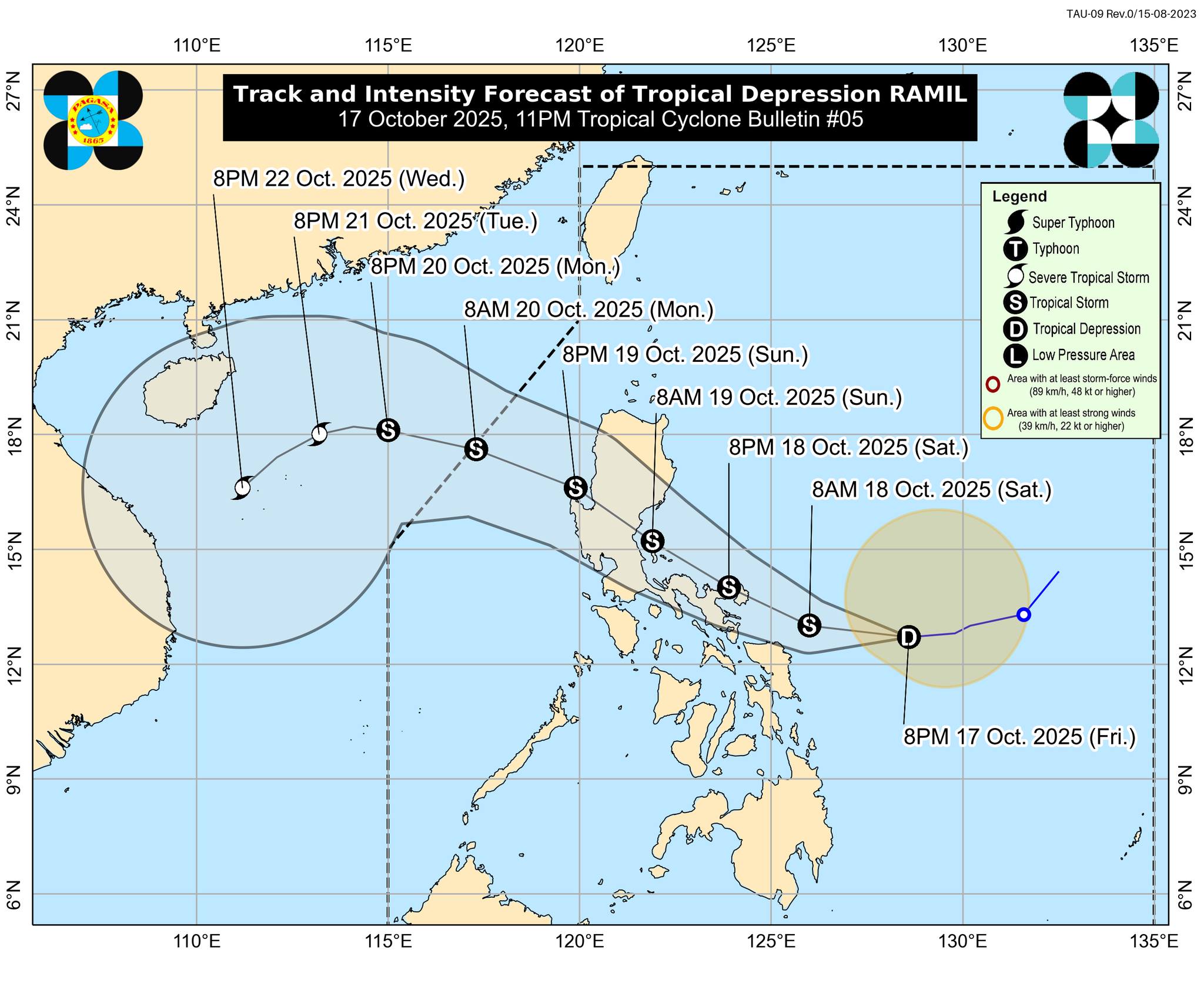
Tropical Depression Ramil has picked up pace while moving westward over the Philippine Sea, according to the state weather bureau PAGASA's 11 p.m. Friday bulletin.
At 10 p.m., Ramil was located 445 km east of Juban, Sorsogon, traveling westward at 30 km/h, up from 15 km/h recorded at 7 p.m.
It has maximum sustained winds of 55 km/h and gustiness of up to 70 km/h.
Under Tropical Cyclone Wind Signal No. 1 are the following areas:
LUZON
- Isabela
- Quirino
- Nueva Vizcaya
- the southern portion of Kalinga (Rizal, City of Tabuk, Tanudan, Lubuagan, Tinglayan)
- Mountain Province
- Ifugao
- Benguet
- the southern portion of Ilocos Sur (Cervantes, Alilem, Sugpon, Suyo, Tagudin)
- La Union
- Pangasinan
- Aurora
- Nueva Ecija
- the eastern portion of Bulacan (Doña Remedios Trinidad, Norzagaray, San Miguel, San Ildefonso, San Rafael, Angat)
- the eastern portion of Tarlac (Camiling, San Clemente, Santa Ignacia, Paniqui, Moncada, San Manuel, Anao, Ramos, Pura, Victoria, City of Tarlac, La Paz, Concepcion, Gerona)
- the eastern portion of Pampanga (Magalang, Arayat, Candaba)
- the northern and eastern portions of Quezon (Tagkawayan, Perez, Alabat, Quezon, Atimonan, Padre Burgos, Unisan, Gumaca, Plaridel, Agdangan, Pagbilao, Mauban, Calauag, Guinayangan, Lopez, Pitogo, Macalelon, General Luna, Catanauan, San Narciso, Buenavista, San Francisco, San Andres, Mulanay, General Nakar, Infanta, Real, Sampaloc) including Polillo Islands
- Camarines Norte
- Camarines Sur
- Catanduanes
- Albay
- Sorsogon
- Burias Island
- Ticao Island
VISAYAS
- Northern Samar
- the northern portion of Eastern Samar (San Policarpo, Arteche, Oras, Dolores, Maslog, Jipapad, Taft, Can-Avid)
- the northern portion of Samar (Matuguinao, San Jose de Buan, Calbayog City, Gandara, Santa Margarita, Pagsanghan, San Jorge)
"The highest Wind Signal that will likely be hoisted throughout its passage is Wind Signal No. 2. However, the possibility of reaching severe tropical storm category before landfall is not ruled out, the worst case scenario is Wind Signal No. 3," PAGASA said.
Ramil is expected to make landfall over Catanduanes on Saturday afternoon or evening. It may also hit Aurora or Quezon on Sunday morning before traversing the rugged terrain of Northern and Central Luzon.
The tropical cyclone will emerge over the West Philippine Sea by Sunday afternoon or evening and is projected to exit the Philippine Area of Responsibility by Monday morning.
"Ramil will continue to intensify while over the Philippine Sea and may reach tropical storm category within the next 12 hours. Further intensification into a severe tropical storm prior to landfall is not ruled out. As Ramil exits the Luzon landmass, further intensification is likely as it traverses the West Philippine Sea," PAGASA said. —VBL, GMA Integrated News
